
Fort Assiniboine facts for kids
Quick facts for kids
Fort Assiniboine
|
|
|---|---|

Skyline and the Athabasca River
|
|

Fort Assiniboine
Location in Woodlands County

Fort Assiniboine
Location in Alberta
|
|
| Country | Canada |
| Province | Alberta |
| Region | Northern Alberta |
| Planning region | Upper Athabasca |
| Municipal district | Woodlands |
| Government | |
| • Type | Unincorporated |
| Area
(2021)
|
|
| • Land | 0.75 km2 (0.29 sq mi) |
| Population
(2021)
|
|
| • Total | 158 |
| • Density | 212/km2 (550/sq mi) |
| Time zone | UTC−7 (MST) |
| • Summer (DST) | UTC−6 (MDT) |
| Fort Assiniboine | |
|---|---|
| Type | Fort |
| Location | Barrhead, Alberta, Canada |
| Nearest city | Edmonton |
| Elevation | 604 m (1,982 ft) |
| Governing body | Woodlands County Council |
Fort Assiniboine is a hamlet in northwest Alberta, Canada, within Woodlands County. It is located along the north shore of the Athabasca River at the junction of Highway 33 and Highway 661. It is approximately 39 kilometres (24 mi) northwest of Barrhead, 62 kilometres (39 mi) southeast of Swan Hills and 91 kilometres (57 mi) northeast of Whitecourt.
Fort Assiniboine was founded as a trading post by the Hudson's Bay Company and became a stopping point along the Klondike Trail. It gets its name from the Assiniboine people. The fort itself no longer exists, but the land on which it stood is designated as a National Historic Site for its archaeological value. The hamlet, built on and around the site of the fort, is a now a local hub for the surrounding agricultural region.
History
By the early 1820s, Hudson’s Bay Company (HBC) trade on Lesser Slave Lake was in decline. The council adopted a resolution in 1823 calling for a fort further up the Athabasca River to reduce transport times. This was part of a much larger effort by the HBC to reorganize its transportation routes, seeking out advantages and efficiencies in its operations after the merger with the North West Company. Under the new plan, Fort Assiniboine on the Athabasca River (the fort was originally named "Athabaska River House" ) became the northwest end of an overland 80 miles (129 km) horse track to Edmonton House/Fort Edmonton on the North Saskatchewan River, thus providing a straighter route from Athabasca Pass within the Rocky Mountains to York Factory on Hudson Bay. A party on horseback could make the trip in about two days. The new route was used by the York Factory Express. The old canoe route involved going far north-northeast up the Athabasca to Fort Chipewyan and then southeast through Methye Portage to Lake Winnipeg. Though the fort never grew as large as some other Alberta forts, its role as a transportation hub and provision centre ensured its survival between the 1820s and 1880s.
Demographics
In the 2021 Census of Population conducted by Statistics Canada, Fort Assiniboine recorded a population of 158 living in 64 of its 74 total private dwellings, a change of -10.2% from its 2016 population of 176. With a land area of 0.75 km2 (0.29 sq mi), it had a population density of 210.7/km2 (546/sq mi) in 2021.
As a designated place in the 2016 Census of Population conducted by Statistics Canada, Fort Assiniboine recorded a population of 176 living in 78 of its 83 total private dwellings, a change of 13.5% from its 2011 population of 155. With a land area of 0.73 km2 (0.28 sq mi), it had a population density of 241.1/km2 (624/sq mi) in 2016.
Attractions
Fort Assiniboine is home to a Hudson Bay style historical museum, known as the Fort Assiniboine Museum and Friendship Club Drop-In Centre, and the World's Largest Wagon Wheel and Pick Axe.
Services
The Fort Assiniboine School, which offers Kindergarten through Grade 12 classes, is located within the hamlet. It is administered by Pembina Hills Regional Division No. 7 (PHRD) and had a preliminary 2009/2010 enrollment of 139 students. Due to low enrollment, the PHRD is currently considering grade reconfiguration to make the school more viable.
Fort Assiniboine is also served by a post office and a public library and has numerous businesses including a general store, a motel, a gas station, a liquor store and a shop that repairs and sells all-terrain and other vehicles.
Climate
| Climate data for Fort Assiniboine | |||||||||||||
|---|---|---|---|---|---|---|---|---|---|---|---|---|---|
| Month | Jan | Feb | Mar | Apr | May | Jun | Jul | Aug | Sep | Oct | Nov | Dec | Year |
| Record high °C (°F) | 13.0 (55.4) |
17.0 (62.6) |
17.0 (62.6) |
29.5 (85.1) |
34.0 (93.2) |
33.3 (91.9) |
32.0 (89.6) |
33.0 (91.4) |
33.0 (91.4) |
29.0 (84.2) |
18.5 (65.3) |
13.3 (55.9) |
34.0 (93.2) |
| Average high °C (°F) | −8.2 (17.2) |
−3.3 (26.1) |
2.9 (37.2) |
11.3 (52.3) |
17.5 (63.5) |
20.7 (69.3) |
22.5 (72.5) |
21.4 (70.5) |
16.1 (61.0) |
10.4 (50.7) |
−1.1 (30.0) |
−7.7 (18.1) |
8.5 (47.3) |
| Daily mean °C (°F) | −14.8 (5.4) |
−10.8 (12.6) |
−4.2 (24.4) |
3.7 (38.7) |
9.7 (49.5) |
13.5 (56.3) |
15.6 (60.1) |
14.4 (57.9) |
9.1 (48.4) |
3.4 (38.1) |
−6.7 (19.9) |
−13.9 (7.0) |
1.6 (34.9) |
| Average low °C (°F) | −21.4 (−6.5) |
−18.2 (−0.8) |
−11.3 (11.7) |
−3.9 (25.0) |
1.9 (35.4) |
6.3 (43.3) |
8.6 (47.5) |
7.4 (45.3) |
2.1 (35.8) |
−3.5 (25.7) |
−12.3 (9.9) |
−20 (−4) |
−5.4 (22.3) |
| Record low °C (°F) | −48 (−54) |
−47 (−53) |
−38.9 (−38.0) |
−30 (−22) |
−8.5 (16.7) |
−2.8 (27.0) |
1.7 (35.1) |
−4 (25) |
−11 (12) |
−30 (−22) |
−38.3 (−36.9) |
−46 (−51) |
−48 (−54) |
| Average precipitation mm (inches) | 18.6 (0.73) |
15.5 (0.61) |
16.1 (0.63) |
24.0 (0.94) |
48.9 (1.93) |
105.3 (4.15) |
118.7 (4.67) |
83.2 (3.28) |
44.0 (1.73) |
16.9 (0.67) |
18.6 (0.73) |
23.4 (0.92) |
533.1 (20.99) |
| Source: Environment Canada | |||||||||||||
Images for kids
-
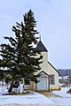
Fort Assiniboine United Church, built in 1948
-
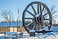
24' Wagon Wheel and Pick Axe at Fort Assiniboine


