
Fort Resolution facts for kids
Quick facts for kids
Fort Resolution
Denı́nu Kų́ę́
|
|
|---|---|
 |
|

Fort Resolution
Location in Northwest Territories

Fort Resolution
Location in Canada
|
|
| Country | Canada |
| Territory | Northwest Territories |
| Region | South Slave Region |
| Territorial electoral district | Tu Nedhé-Wiilideh |
| Census division | Region 5 |
| Hamlet | 5 January 2011 |
| Area | |
| • Land | 455.22 km2 (175.76 sq mi) |
| Elevation | 160 m (520 ft) |
| Population
(2016)
|
|
| • Total | 470 |
| • Density | 1.0/km2 (3/sq mi) |
| Time zone | UTC−07:00 (MST) |
| • Summer (DST) | UTC−06:00 (MDT) |
| Canadian Postal code |
X0E 0M0
|
| Area code(s) | 867 |
| Telephone exchange | 394 |
| - Living cost | 142.5 |
| - Food price index | 144.0 |
| Climate | Dsc |
| Sources: Department of Municipal and Community Affairs, Prince of Wales Northern Heritage Centre, Canada Flight Supplement 2013 figure based on Edmonton = 100 2015 figure based on Yellowknife = 100 |
|
Fort Resolution (Denı́nu Kų́ę́ (pronounced "deh-nih-noo-kwenh") "moose island place") is a hamlet in the South Slave Region of the Northwest Territories, Canada. The community is situated at the mouth of the Slave River, on the shores of Great Slave Lake, and at the end of the Fort Resolution Highway (Highway 6). It is the headquarters of the Deninu Kųę́ First Nation, whose Chief is Louis Balsillie.
It is the oldest documented European community in the Northwest Territories, built in 1819, and was a key link in the fur trade's water route north. Fort Resolution is designated as a National Historic Site of Canada as the oldest continuously occupied place in the Northwest Territories with origins in the fur trade and the principal fur trade post on Great Slave Lake.
Fort Resolution's Deninoo School offers K-12 schooling. The town also has a hockey arena, community hall, a nursing station, a youth centre, Royal Canadian Mounted Police, a bed and breakfast, a 'Northern' general store, a convenience store, one diner and two gas stations. Fort Resolution Airport services charter and medivac flights only. The oldest building in town is the historic Roman Catholic Church, built in the early 19th century; there is also a Protestant church in the hamlet. The beach along Great Slave Lake is a prime spot for summer swimming, bird watching, fishing or relaxing. Local people engage in fishing, hunting, and trapping year-round.
The nearby site of Pine Point was once a thriving lead mine. When the value of lead plummeted in the 1980s, the Pine Point Mine closed, and the township was evacuated. Pine Point houses were sold cheaply, and many of the buildings were then moved to Fort Resolution (including the hockey arena), Hay River and Northern Alberta.
Deninoo Days in late August celebrate the beginning of moose hunting season with parades, traditional races, games and talent competitions. Recreational opportunities include camping, canoeing and fishing (self-guided, or available through several outfitters). Little Buffalo River Crossing is a nearby territorial park, with historical and natural attractions, accessible by road and featuring a campground with 12 sites.
Contents
Demographics
The population in 2016 was 470 according to the Census, a decrease of -0.8% from 2011. Of these 430 were listed as Indigenous. The majority of townspeople are of Dene (320) and Métis (105) descent. The predominant languages are English, Chipewyan and Michif. In 2017 the Government of the Northwest Territories reported that the population was 507 with an average yearly growth rate of 0.0% from 2007.
| Historical population | |||||||||||||||||||||||||||||||||||||||||||||||||||||||||||||||||||||||||
|---|---|---|---|---|---|---|---|---|---|---|---|---|---|---|---|---|---|---|---|---|---|---|---|---|---|---|---|---|---|---|---|---|---|---|---|---|---|---|---|---|---|---|---|---|---|---|---|---|---|---|---|---|---|---|---|---|---|---|---|---|---|---|---|---|---|---|---|---|---|---|---|---|---|
|
|
||||||||||||||||||||||||||||||||||||||||||||||||||||||||||||||||||||||||
| Sources: NWT Bureau of Statistics (2001 - 2017) | |||||||||||||||||||||||||||||||||||||||||||||||||||||||||||||||||||||||||
First Nations
Fort Resolution is represented by the Deninu Kue First Nation and are part of the Akaitcho Territory Government.
Gallery
-
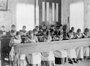
Study period at Roman Catholic Indian Residential School
-
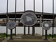
Treaty 8 site in Fort Resolution
-
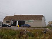
The Northern Store in Fort Resolution
-
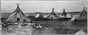
Tepees of the Dogrib Indians on the shores of Slave Lake at Fort Resolution, circa 1907
-
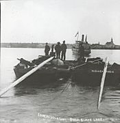
Boats on the Great Slave Lake at Fort Resolution, 1900s
_Resolution,_Northwest_Territories_-_Pensionnat_indien_catholique_de_(Fort)_Resolution_(Territoires_du_Nord-Ouest)_(14112742441).jpg)
.jpg)


.jpg)
Climate
Fort Resolution has a subarctic climate (Dfc) with short, mild summers and long, cold winters lasting from October through April.
| Climate data for Fort Resolution | |||||||||||||
|---|---|---|---|---|---|---|---|---|---|---|---|---|---|
| Month | Jan | Feb | Mar | Apr | May | Jun | Jul | Aug | Sep | Oct | Nov | Dec | Year |
| Average high °C (°F) | −25 (−13) |
−20 (−4) |
−14 (6) |
0 (32) |
10 (50) |
17 (62) |
21 (69) |
18 (64) |
11 (51) |
2 (35) |
−9 (15) |
−17 (2) |
0 (32) |
| Average low °C (°F) | −31 (−23) |
−27 (−16) |
−24 (−11) |
−11 (12) |
0 (32) |
5 (41) |
10 (50) |
9 (48) |
3 (37) |
−3 (26) |
−15 (5) |
−25 (−13) |
−9 (15) |
| Average precipitation mm (inches) | 15 (0.6) |
7.6 (0.3) |
13 (0.5) |
10 (0.4) |
25 (1.0) |
30 (1.2) |
28 (1.1) |
36 (1.4) |
36 (1.4) |
28 (1.1) |
33 (1.3) |
15 (0.6) |
280 (10.9) |
| Source: Weatherbase | |||||||||||||
