
Franklin County, Illinois facts for kids
Quick facts for kids
Franklin County
|
|
|---|---|

Franklin County Courthouse in Benton
|
|

Location within the U.S. state of Illinois
|
|
 Illinois's location within the U.S. |
|
| Country | |
| State | |
| Founded | January 2, 1818 |
| Named for | Benjamin Franklin |
| Seat | Benton |
| Largest city | West Frankfort |
| Area | |
| • Total | 431 sq mi (1,120 km2) |
| • Land | 409 sq mi (1,060 km2) |
| • Water | 23 sq mi (60 km2) 5.2% |
| Population
(2020)
|
|
| • Total | 37,804 |
| • Density | 87.71/sq mi (33.87/km2) |
| Time zone | UTC−6 (Central) |
| • Summer (DST) | UTC−5 (CDT) |
| Congressional district | 12th |
Franklin County is a county in Southern Illinois. At the 2020 census, it had a population of 37,804. The largest city is West Frankfort and the county seat is Benton. This area of Southern Illinois is known locally as "Little Egypt".
Contents
History
Franklin County was established on January 2, 1818 and formed from parts of Gallatin and White counties. It was named for Benjamin Franklin.
-
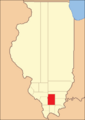
Franklin County at the time of its formation in 1818
-
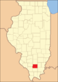
The creation of Williamson County in 1839 reduced Franklin to its current borders.


Geography
According to the U.S. Census Bureau, the county has a total area of 431 square miles (1,120 km2), of which 409 square miles (1,060 km2) is land and 23 square miles (60 km2) (5.2%) is water. Justin Kay State Recreation Area is located in this county.
Climate and weather
| Weather chart for Benton, Illinois | |||||||||||||||||||||||||||||||||||||||||||||||
|---|---|---|---|---|---|---|---|---|---|---|---|---|---|---|---|---|---|---|---|---|---|---|---|---|---|---|---|---|---|---|---|---|---|---|---|---|---|---|---|---|---|---|---|---|---|---|---|
| J | F | M | A | M | J | J | A | S | O | N | D | ||||||||||||||||||||||||||||||||||||
|
2.9
39
21
|
2.9
45
26
|
4.2
56
36
|
4.5
67
45
|
4.6
76
54
|
4.1
85
63
|
3.2
90
68
|
3
88
65
|
2.9
81
58
|
2.9
69
45
|
4.5
56
37
|
3.6
43
26
|
||||||||||||||||||||||||||||||||||||
| temperatures in °F precipitation totals in inches source: The Weather Channel |
|||||||||||||||||||||||||||||||||||||||||||||||
|
Metric conversion
|
|||||||||||||||||||||||||||||||||||||||||||||||
In recent years, average temperatures in the county seat of Benton have ranged from a low of 21 °F (−6 °C) in January to a high of 90 °F (32 °C) in July, although a record low of −22 °F (−30 °C) was recorded in January 1977 and a record high of 104 °F (40 °C) was recorded in August 2007. Average monthly precipitation ranged from 2.87 inches (73 mm) in February to 4.59 inches (117 mm) in May.
Adjacent counties
- Jefferson County (north)
- Hamilton County (east)
- Saline County (southeast)
- Williamson County (south)
- Jackson County (southwest)
- Perry County (west)
Major highways
 Interstate 57
 Illinois Route 14
 Illinois Route 34
 Illinois Route 37
 Illinois Route 148
 Illinois Route 149
 Illinois Route 154
 Illinois Route 184
Demographics
| Historical population | |||
|---|---|---|---|
| Census | Pop. | %± | |
| 1820 | 1,763 | — | |
| 1830 | 4,083 | 131.6% | |
| 1840 | 3,682 | −9.8% | |
| 1850 | 5,681 | 54.3% | |
| 1860 | 9,393 | 65.3% | |
| 1870 | 12,652 | 34.7% | |
| 1880 | 16,129 | 27.5% | |
| 1890 | 17,138 | 6.3% | |
| 1900 | 19,675 | 14.8% | |
| 1910 | 25,943 | 31.9% | |
| 1920 | 57,293 | 120.8% | |
| 1930 | 59,442 | 3.8% | |
| 1940 | 53,137 | −10.6% | |
| 1950 | 48,685 | −8.4% | |
| 1960 | 39,281 | −19.3% | |
| 1970 | 38,329 | −2.4% | |
| 1980 | 43,201 | 12.7% | |
| 1990 | 40,319 | −6.7% | |
| 2000 | 39,018 | −3.2% | |
| 2010 | 39,561 | 1.4% | |
| 2020 | 37,804 | −4.4% | |
| U.S. Decennial Census 1790-1960 1900-1990 1990-2000 2010-2013 |
|||

As of the 2010 United States Census, there were 39,561 people, 16,617 households, and 10,912 families residing in the county. The population density was 96.8 inhabitants per square mile (37.4/km2). There were 18,525 housing units at an average density of 45.3 per square mile (17.5/km2). The racial makeup of the county was 97.7% white, 0.3% Asian, 0.3% American Indian, 0.3% black or African American, 0.3% from other races, and 1.1% from two or more races. Those of Hispanic or Latino origin made up 1.2% of the population. In terms of ancestry, 21.8% were German, 18.7% were Irish, 15.9% were English, 9.4% were American, and 5.7% were Italian.
Of the 16,617 households, 30.0% had children under the age of 18 living with them, 48.8% were married couples living together, 11.6% had a female householder with no husband present, 34.3% were non-families, and 30.0% of all households were made up of individuals. The average household size was 2.35 and the average family size was 2.88. The median age was 41.8 years.
The median income for a household in the county was $34,381 and the median income for a family was $43,170. Males had a median income of $39,122 versus $28,950 for females. The per capita income for the county was $18,504. About 14.5% of families and 19.8% of the population were below the poverty line, including 30.5% of those under age 18 and 9.9% of those age 65 or over.
Communities
Cities
Villages

Census-designated place
Townships
Franklin County is divided into twelve townships:
- Barren
- Benton
- Browning
- Cave
- Denning
- Eastern
- Ewing
- Frankfort
- Goode
- Northern
- Six Mile
- Tyrone
Education
Regional
- Franklin, Johnson, Massac, and Williamson County Regional Office of Education #21
Primary and secondary
- Christopher Unit School District #99
- Sesser Unit School District
- Benton School District #47
- Frankfort Community Unit School District #168
- Zeigler-Royalton Community Unit School District #188
- Thompsonville Community Unit School District #174
- Ewing-Northern Community Unit School District #115
Higher education
- John A. Logan College Extension Center - West Frankfort
Specialized
- Franklin & Jefferson County Special Education Cooperative
See also
 In Spanish: Condado de Franklin (Illinois) para niños
