Franktown, Colorado facts for kids
Quick facts for kids
Franktown, Colorado
|
|
|---|---|

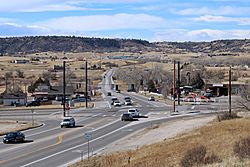
Franktown and the intersection of state highways 83 and 86.
|
|

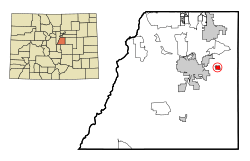
Location of the Franktown CDP in Douglas County, Colorado. Colorado
|
|
| Country | |
| State | |
| County | Douglas County |
| Government | |
| • Type | unincorporated community |
| Area | |
| • Total | 2.958 sq mi (7.661 km2) |
| • Land | 2.944 sq mi (7.625 km2) |
| • Water | 0.014 sq mi (0.036 km2) |
| Elevation | 6,197 ft (1,889 m) |
| Population
(2010)
|
|
| • Total | 395 |
| • Density | 134/sq mi (52/km2) |
| Time zone | UTC-7 (MST) |
| • Summer (DST) | UTC-6 (MDT) |
| ZIP Code |
80116
|
| Area codes | 303 & 720 |
| GNIS feature | Franktown CDP |
| Primary Highways | |
Franktown is an unincorporated town, a post office, and a census-designated place (CDP) located in and governed by Douglas County, Colorado, United States. The CDP is a part of the Denver–Aurora–Lakewood, CO Metropolitan Statistical Area. The Franktown post office has the ZIP Code 80116 . At the United States Census 2010, the population of the Franktown CDP was 395, while the population of the 80116 ZIP Code Tabulation Area was 3,942 including adjacent areas. Douglas County governs the unincorporated town.
Contents
History
Franktown is named for Hon. J. Frank Gardner, an early resident. Franktown was the first county seat of Douglas County, serving in this role from 1861 until 1863.
Pike's Peak Grange No. 163 in Franktown is listed on the National Register of Historic Places.
Geography
Franktown is located in eastern Douglas County at 39°23′25″N 104°45′14″W / 39.39028°N 104.75389°W (39.390378, -104.753961). Colorado State Highways 83 and 86 intersect in the center of town. SH 83 leads north 9 miles (14 km) to Parker and south 45 miles (72 km) to Colorado Springs, while SH 86 leads east 9 miles (14 km) to Elizabeth and west 7 miles (11 km) to Castle Rock, the Douglas County seat.
According to the United States Census Bureau, the Franktown CDP has a total area of 3.0 square miles (7.7 km2), of which 0.02 square miles (0.04 km2), or 0.47%, is water. Franktown is in the valley of Cherry Creek, which flows north to join the South Platte River in downtown Denver.
Demographics
The United States Census Bureau initially defined the Franktown CDP for the United States Census 2000.
| Franktown CDP, Colorado | ||
|---|---|---|
| Year | Pop. | ±% |
| 2000 | 99 | — |
| 2010 | 395 | +299.0% |
| 2020 | — | |
| Source: United States Census Bureau | ||
Education
The Douglas County School District serves Franktown.
See also
 In Spanish: Franktown (Colorado) para niños


