
Franz Josef Land facts for kids

Map of Franz Josef Land.
|
|

Location of Franz Josef Land.
|
|
| Geography | |
|---|---|
| Location | Arctic Ocean |
| Coordinates | 80°34′N 54°47′E / 80.567°N 54.783°E |
| Archipelago | Franz Josef Land |
| Area | 16,134 km2 (6,229 sq mi) |
| Administration | |
| Demographics | |
| Population | 0 |
Franz Josef Land is an archipelago, north of Novaya Zemlya in the Arctic Ocean. It is part of Russia. It is administered from Archangelsk. It is made of 191 islands. Cape Fligely is the northernmost point of Eurasia. Getting to the island group is only possible during a few weeks in summer, in most summers. The northernmost point of Franz-Josef Land is only about 900 km from the North Pole - this means that the only places which are closer are Greenland, and Ellesmere Island in Canada. In the south, about 370 km of ocean separates the group from Novaya Zemlya. The group consists of about 191 islands. Roughly 80% of the islands are covered with ice all the time. The group has a volcanic origin. In 2007, there were two manned stations: Nagurskoye, a weather station, with 5 people, and observatory with 4 people. Victoria Island is 160 km west of the other islands, about half way to Svalbard.
Photo's
-
Nagurskoye station, on Alexandraland
-

Ernst Krenkel polar station, on Hayes Island
-
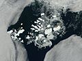
Franz Josef Land, NASA satellite image, August 2011


Images for kids
-

Austro-Hungarian North Pole Expedition
-
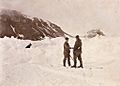
The Nansen–Jackson meeting at Cape Flora, 17 June 1896 (a posed photograph taken hours after the initial meeting)
-
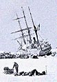
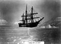
The Stella Polare was trapped and threatened to sink. The crew were obliged to land with the utmost haste and to secure materials for building a dwelling.
-
America anchored at Tepliz Bay
-

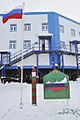
Nagurskoye is Russia's northernmost military base
-
Cape Brice, Ziegler Island, Franz Josef Land
-
Bell Island
-
Cape Tegetthoff on Hall Island
-
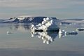
Iceberg at Heiss Island in September 2007.
-
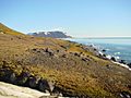
Northbrook Island
-
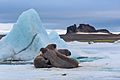
Walrus on Heiss Island
-
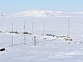
Polar Geophysical Observatory on Heiss Island
_b_593.jpg)


_02.jpg)


See also
 In Spanish: Tierra de Francisco José para niños
