
Fredericksburg, Virginia facts for kids
Quick facts for kids
Fredericksburg, Virginia
|
|||||
|---|---|---|---|---|---|
| City of Fredericksburg | |||||

Historic downtown Fredericksburg
|
|||||
|
|||||
| Motto(s):
America's Most Historic City
|
|||||

Location of Fredericksburg in Northern Virginia
|
|||||

Fredericksburg, Virginia
Location in Northern Virginia

Fredericksburg, Virginia
Location in Virginia

Fredericksburg, Virginia
Location in the United States
|
|||||
| Country | United States | ||||
| State | Commonwealth of Virginia | ||||
| County | None (Independent city since 1879, adjacent to Spotsylvania County) | ||||
| Founded | 1728 | ||||
| Incorporated | 1781 | ||||
| Named for | Frederick, Prince of Wales | ||||
| Area | |||||
| • Independent city | 10.52 sq mi (27.24 km2) | ||||
| • Land | 10.45 sq mi (27.07 km2) | ||||
| • Water | 0.07 sq mi (0.18 km2) | ||||
| Elevation | 59 ft (18 m) | ||||
| Population
(2020)
|
|||||
| • Independent city | 27,982 | ||||
| • Density | 2,659.9/sq mi (1,027.24/km2) | ||||
| • Urban | 141,238 (US: 231st) | ||||
| Time zone | UTC−05:00 (Eastern (EST)) | ||||
| • Summer (DST) | UTC−04:00 (EDT) | ||||
| ZIP Codes |
22401 (USPS designates 5 zip codes for Fredericksburg, but 4 of them lie outside the Independent City in surrounding counties; only 22401 lies inside it)
|
||||
| Area code(s) | 540 | ||||
| FIPS code | 51-29744 | ||||
| GNIS feature ID | 1494947 | ||||
| * Independent from Spotsylvania County in 1879 | |||||


Fredericksburg is an independent city located in the Commonwealth of Virginia in the United States. As of the 2020 census, the population was 27,982. The Bureau of Economic Analysis of the United States Department of Commerce combines the city of Fredericksburg with neighboring Spotsylvania County for statistical purposes.
Fredericksburg is located 48 miles (77 km) south of Washington, D.C. and 53 miles (85 km) north of Richmond.
Located near where the Rappahannock River crosses the Atlantic Seaboard fall line, Fredericksburg was a prominent port in Virginia during the colonial era. During the Civil War, Fredericksburg, located halfway between the capitals of the opposing forces, was the site of the Battle of Fredericksburg and Second Battle of Fredericksburg. These battles are preserved, in part, as the Fredericksburg and Spotsylvania National Military Park. More than 10,000 African-Americans in the region left slavery for freedom in 1862 alone, getting behind Union lines. Tourism is a major part of the economy. Approximately 1.5 million people visit the Fredericksburg area annually, including the battlefield park, the downtown visitor center, events, museums, art shops, galleries, and many historical sites.
Fredericksburg is home to Central Park (as of 2004, the second-largest mall on the East Coast). The Spotsylvania Towne Centre is located in Spotsylvania County, adjacent to the city. Major employers include the University of Mary Washington (named for the mother of George Washington, who lived here), Mary Washington Healthcare, and GEICO. Many Fredericksburg-area residents commute to work by car, bus, and rail to Washington D.C. and Richmond, as well as Fairfax, Prince William, and Arlington counties.
Contents
History
At the time of European encounter, the inhabitants of the area that became Fredericksburg were a Siouan-speaking tribe called the Manahoac. English colonists recorded the name of the Manahoac village there as Mahaskahod.
Colonial
Located on the Rappahannock River near the head of navigation at the fall line, Fredericksburg developed as the frontier of colonial Virginia shifted west out of the coastal plain. The land on which the city was founded was part of a tract patented in 1671. The Virginia General Assembly established a fort on the Rappahannock in 1676, just below the present-day city. In 1714, Lt. Gov. Alexander Spotswood sponsored a German settlement called Germanna on the Rapidan River, a tributary of the Rappahannock upstream from the future site of the city, and led an expedition westward over the Blue Ridge Mountains in 1716.
As interest in the frontier grew, the colonial assembly responded by forming a new county named Spotsylvania (after Alexander Spotswood, the governor at the time) in 1720 and establishing Fredericksburg in 1728 as a port for the county, of which it was then a part. Named for Frederick, Prince of Wales, son of King George II, the colonial town's streets bore the names of members of the royal family. The county court was moved to Fredericksburg in 1732, and the town served as county seat until 1780, when the courthouse was moved closer to the county center in Spotsylvania County. In 1781, Fredericksburg was incorporated as a town, with its own court, council, and mayor. It received its charter as a city in 1879, and under Virginia law was separated from Spotsylvania County. The city adopted its present city manager/council form of government in 1911.
The city has close associations with George Washington, whose family moved to Ferry Farm in Stafford County just off the Rappahannock River opposite Fredericksburg in 1738. Washington's mother Mary later moved to the city, and his sister Betty lived at Kenmore, a plantation house then outside the city. Other significant early residents include the Revolutionary War generals Hugh Mercer and George Weedon, naval war hero John Paul Jones, and future U.S. president James Monroe. Thomas Jefferson wrote the Virginia Statute for Religious Freedom in Fredericksburg.
19th century
During the 19th century, Fredericksburg sought to maintain its sphere of trade, but with limited success. It promoted the development of a canal on the Rappahannock and construction of a turnpike and plank road to bind the interior country to the market town. By 1837, a north-south railroad, which became the Richmond, Fredericksburg and Potomac Railroad, linked the town to Richmond, the state capital. A much-needed railroad joining the town to the farming region to the west was not finished until after the Civil War.

During the Civil War, Fredericksburg gained strategic importance due to its location midway between Washington and Richmond, the opposing capitals of the Union and the Confederacy. During the Battle of Fredericksburg, December 11–15, 1862, the town sustained significant damage from bombardment and looting by the Union forces. A Second Battle of Fredericksburg was fought in and around the town on May 3, 1863, in connection with the Chancellorsville campaign (April 27, 1863 – May 6, 1863). The battles of the Wilderness and Spotsylvania Court House were fought nearby in May 1864.
20th century
After the war, Fredericksburg recovered its former position as a center of local trade and slowly grew beyond its prewar boundaries. Neither the city of Fredericksburg, nor either of the surrounding counties, reached the population level of the census of 1860 until the 1940s (spurred by World War II). The 1960s brought renewed growth and development, fueled by the "arrival" of Interstate 95. By the 1970s, the city and the area had become a bedroom community for jobs in Northern Virginia and Washington, D.C., largely related to the city's location near four military installations: Quantico Marine Corps Base, the Army's Fort Belvoir, the Navy's Dahlgren Surface Weapons Base, and the National Guard's Fort A.P. Hill. In addition, career military personnel, assigned to the Pentagon (in Arlington, Virginia), find Fredericksburg a convenient home base.
The University of Mary Washington was founded in Fredericksburg in 1908 as the State Normal and Industrial School for Women. Adopting the name of Mary Washington College in 1938, the college was for many years associated with the University of Virginia as a women's liberal arts college. The college became independent of UVA and began to accept men in 1970. Recently, the college changed names from Mary Washington College to the University of Mary Washington. Two separate campuses for graduate and professional studies and education and research are located in suburban Stafford County and in rural King George County near the Dahlgren naval base, respectively.
The power chord of modern guitar was first developed by Link Wray in Fredericksburg in 1958 during his first improvisation of the instrumental piece "Rumble", a single released by Wray & His Ray Men. The local music scene includes a wide variety of genres.
A commuter rail line – the Virginia Railway Express – was established in the 1980s, providing passage to job sites north of Fredericksburg.
The city has become the regional healthcare center for the area. Retail, real estate, and other commercial growth exploded into the early 21st century, eventually slowing during the "Great Recession" beginning in 2007.
Geography and climate
According to the United States Census Bureau, the city has a total area of 10.5 square miles (27.2 km2), of which 10.4 square miles (27.0 km2) is land and 0.1 square miles (0.2 km2), or 0.67%, is water. The city is part of the boundary between the Piedmont and Tidewater regions, and as such is located on the fall line, as evident on the Rappahannock River. US 1, US 17, and I-95 all pass through the city, which is located 53 miles (85 km) south of downtown Washington, D.C.
The city is bounded on the north and east by the Rappahannock River; across the river is Stafford County. The city is bounded on the south and west by Spotsylvania County.
Fredericksburg has a four-season humid subtropical climate (Köppen Cfa), with cool winters and hot, humid summers. Daytime temperatures for much of the year average slightly higher than in Washington, DC due to the southerly aspect, although the inland location and distance from the urban heat island present in the nation's capital make for significantly cooler low temperatures.
| Climate data for Fredericksburg, Virginia (downtown, 1981−2010 normals) | |||||||||||||
|---|---|---|---|---|---|---|---|---|---|---|---|---|---|
| Month | Jan | Feb | Mar | Apr | May | Jun | Jul | Aug | Sep | Oct | Nov | Dec | Year |
| Average high °F (°C) | 45.3 (7.4) |
48.7 (9.3) |
56.9 (13.8) |
67.5 (19.7) |
75.9 (24.4) |
84.5 (29.2) |
87.8 (31.0) |
86.5 (30.3) |
80.0 (26.7) |
69.9 (21.1) |
59.4 (15.2) |
49.0 (9.4) |
67.7 (19.8) |
| Average low °F (°C) | 24.3 (−4.3) |
26.1 (−3.3) |
33.2 (0.7) |
43.0 (6.1) |
52.4 (11.3) |
62.5 (16.9) |
67.1 (19.5) |
65.7 (18.7) |
58.0 (14.4) |
44.9 (7.2) |
35.6 (2.0) |
27.3 (−2.6) |
45.1 (7.3) |
| Average precipitation inches (mm) | 2.90 (74) |
2.51 (64) |
3.99 (101) |
3.35 (85) |
4.08 (104) |
3.97 (101) |
4.53 (115) |
3.39 (86) |
4.32 (110) |
3.38 (86) |
3.75 (95) |
3.18 (81) |
43.35 (1,102) |
| Average precipitation days (≥ 0.01 in) | 9.5 | 10.1 | 11.4 | 11.7 | 12.5 | 10.2 | 13.1 | 10.0 | 9.4 | 8.8 | 9.8 | 11.2 | 127.7 |
| Source: NOAA (precipitation days at Fredericksburg National Battlefield Park) | |||||||||||||
Demographics
| Historical population | |||
|---|---|---|---|
| Census | Pop. | %± | |
| 1830 | 3,308 | — | |
| 1840 | 3,974 | 20.1% | |
| 1850 | 4,061 | 2.2% | |
| 1860 | 5,022 | 23.7% | |
| 1870 | 4,046 | −19.4% | |
| 1880 | 5,010 | 23.8% | |
| 1890 | 4,528 | −9.6% | |
| 1900 | 5,068 | 11.9% | |
| 1910 | 5,874 | 15.9% | |
| 1920 | 5,882 | 0.1% | |
| 1930 | 6,819 | 15.9% | |
| 1940 | 10,066 | 47.6% | |
| 1950 | 12,158 | 20.8% | |
| 1960 | 13,639 | 12.2% | |
| 1970 | 14,450 | 5.9% | |
| 1980 | 15,322 | 6.0% | |
| 1990 | 19,027 | 24.2% | |
| 2000 | 19,279 | 1.3% | |
| 2010 | 24,286 | 26.0% | |
| 2020 | 27,982 | 15.2% | |
| U.S. Decennial Census 1790–1960 1900–1990 1990–2000 2010–2020 |
|||
2020 census
| Race / Ethnicity | Pop 2010 | Pop 2020 | % 2010 | % 2020 |
|---|---|---|---|---|
| White alone (NH) | 14,760 | 15,201 | 60.78% | 54.32% |
| Black or African American alone (NH) | 5,367 | 5,956 | 22.10% | 21.29% |
| Native American or Alaska Native alone (NH) | 58 | 86 | 0.24% | 0.31% |
| Asian alone (NH) | 670 | 1,325 | 2.76% | 4.74% |
| Pacific Islander alone (NH) | 16 | 24 | 0.07% | 0.09% |
| Some Other Race alone (NH) | 64 | 280 | 0.26% | 1.00% |
| Mixed Race/Multi-Racial (NH) | 744 | 1,638 | 3.06% | 5.85% |
| Hispanic or Latino (any race) | 2,607 | 3,472 | 10.73% | 12.41% |
| Total | 24,286 | 27,982 | 100.00% | 100.00% |
Note: the US Census treats Hispanic/Latino as an ethnic category. This table excludes Latinos from the racial categories and assigns them to a separate category. Hispanics/Latinos can be of any race.
2020 Census
As of the census of 2020, there were about 29,000 people, 8,102 households, and 3,925 families residing in the city. The population density was 1,833.0 inhabitants per square mile (707.7/km2). There were 8,888 housing units at an average density of 845.0 per square mile (326.3/km2). The racial makeup of the city was 54% White, 21% Black or African American, 0.31% Native American, 4.74 Asian, 0.067 Pacific Islander, 2.56% from other races, and 1.95% from two or more races.12% of the population were Hispanic or Latino of any race.
There were 8,102 households, out of which 21.6% had children under the age of 18 living with them, 31.8% were married couples living together, 13.1% had a female householder with no husband present, and 51.6% were non-families. 39.2% of all households were made up of individuals, and 12.8% had someone living alone who was 65 years of age or older. The average household size was 2.09 and the average family size was 2.81.
In the city, the population was spread out, with 17.8% under the age of 18, 23.8% from 18 to 24, 27.2% from 25 to 44, 18.4% from 45 to 64, and 12.8% who were 65 years of age or older. The median age was 30 years. For every 100 females, there were 81.8 males. For every 100 females age 18 and over, there were 78.4 males.
The median income for a household in the city was $34,585, and the median income for a family was $47,148. Males had a median income of $33,641 versus $25,037 for females. The per capita income for the city was $21,527. 15.5% of the population and 10.4% of families were below the poverty line. Out of the total population, 19.9% of those under the age of 18 and 8.8% of those 65 and older were living below the poverty line.
Culture and recreation
Architecture and historic sites
|
Fredericksburg Historic District
|
|
 |
|
| Location | Roughly bounded by Rappahannock River, Hazel Run, Prince Edward and Canal Sts., Fredericksburg, Virginia |
|---|---|
| Area | 200 acres (81 ha) |
| NRHP reference No. | 71001053 |
| Significant dates | |
| Added to NRHP | September 22, 1971 |

Despite recent decades of suburban growth, reminders of the area's past abound. The 40-block Fredericksburg Historic District, on the National Register of Historic Places, embraces the city's downtown area and contains more than 350 buildings dating to the 18th and 19th centuries. Crowds of tourists are drawn to the historic district of Fredericksburg during the summer months.

Within the historic district, four 18th-century historic sites have been managed by Preservation Virginia but, following a full, statewide reorganization by that organization, the newly created "Washington Heritage Museums" group will acquire the sites by 2014: the Mary Washington House, where George Washington's mother spent her final years; the late 18th century Rising Sun Tavern and the Hugh Mercer Apothecary Shop (the fourth is only open on Historic Garden Week). Important public buildings include the 1852 courthouse designed by James Renwick, whose works include the Smithsonian Institution's castle building in Washington and St. Patrick's Cathedral in New York City, and the 1816 town hall and market house. The latter building housed the Fredericksburg Area Museum and Cultural Center which was closed in 2015 due to a lack of funding. Another site of interest is St. George's Church. The James Monroe Museum and Memorial Library is located on the site where Monroe practiced law from 1786 to 1788. The museum is housed in a building that is made up of three individual structures, constructed at different times, beginning in 1816.
Nearby the historic district is Kenmore, the plantation home of Washington's sister Betty and her husband patriot Fielding Lewis.
The area's Civil War battles are commemorated in Fredericksburg and Spotsylvania National Military Park. Formed by an act of Congress in 1927, the national military park preserves portions of the battlefields of Fredericksburg, Chancellorsville, the Wilderness, and Spotsylvania Court House. The Fredericksburg National Cemetery, also part of the park, is located on Marye's Heights on the Fredericksburg battlefield and contains more than 15,000 Union burials from the area's battlefields.
Notable 20th-century sites and structures include the campus of the University of Mary Washington (begun in 1908), and Carl's Ice Cream, an Art Moderne roadside ice cream stand on the National Register of Historic Places on U.S. Route 1.
Nearby points of interest include Ferry Farm historic site in Stafford County where Washington spent his boyhood immediately across the river from Fredericksburg, and the George Washington Birthplace National Monument, located 38 miles to the east in Westmoreland County. The historic community of Falmouth lies across the Rappahannock to the north and includes the historic house Belmont, home of American Impressionist artist Gari Melchers.
Parks
Public parks run by the city include:
- Old Mill Park
- Alum Spring Park
- Hurkamp Park
- Dixon Park
Public Library
Central Rappahannock Regional Library
Transportation

Fredericksburg is traversed by a series of rural and suburban four-lane highways and a multitude of small, two-lane roads. The primary highway serving Fredericksburg is Interstate 95, which connects northward to Washington, D.C. and southward to Richmond, Virginia. Among the major arterial roads is U.S. Route 17, providing northwest–southeast transportation across the region. Through Fredericksburg, I-95 and US 17 are concurrent, though a local business route provides local access to downtown. Route 3 (Plank Road) is a major east–west route that connects downtown Fredericksburg (via the Blue and Gray Parkway bypass), southern Stafford and King George counties, and Route 301 to the east with the large shopping centers, Spotsylvania Town Center and Central Park. To the west, Route 3 reaches Culpeper, where it meets Route 29 and Route 15.

Most of Fredericksburg's traffic flow is to or from the north (Washington, D.C. metropolitan area) during peak commuting hours, primarily via I-95 and U.S. Route 1. The Route 1 bridge over the Rappahannock River is often a traffic bottleneck, and Route 3 has become increasingly congested as residential development grows and the location of major regional shopping centers.
As an alternative to I-95, some commuters use the Virginia Railway Express rail service to Washington. Long-distance rail service is available on Amtrak, which serves Fredericksburg via the Northeast Regional and Carolinian/Piedmont routes.
Fredericksburg Regional Transit (FRED) is a bus service that started in 1996 in Fredericksburg and serves most area communities, retail shopping centers, two VRE stations, and downtown Fredericksburg.
Four major airports serve Fredericksburg and the surrounding area. Reagan National and Dulles International Airports are to the north within Virginia. Beyond them to the northeast is Baltimore/Washington International in Maryland, and Richmond International is south of Fredericksburg.
Sister cities
Sports
The Fredericksburg Nationals minor league baseball team began play at Virginia Credit Union Stadium in 2021.
Sports at the secondary education level are run through the Virginia High School League. On the collegiate level are the University of Mary Washington Eagles. Other amateur athletics include Fredericksburg FC of the National Premier Soccer League (NPSL); and the Rappahannock Rugby Club, a senior men's rugby club competing in Division III of the Potomac Rugby Union.
Education

Primary and secondary schools
The Fredericksburg City Public Schools are run independently of the surrounding counties. The public primary and secondary schools include:
- James Monroe High School
- Walker-Grant Middle School
- Hugh Mercer Elementary School
- Lafayette Elementary School
Private schools include:
- Fredericksburg Academy
- Fredericksburg Christian School
- Saint Michael the Archangel High School
- Lighthouse Academy
Higher education
The University of Mary Washington, established in 1908 and opening in 1911, is a four-year public university within the city.
Germanna Community College, established in 1970, is a public two-year program with a campus in Fredericksburg.
Strayer University has a campus located in Fredericksburg, on the Stafford County line, along Riverside Parkway.
Notable people


18th century and before
- Lewis Craig (brother of Elijah Craig), Baptist preacher imprisoned for religious freedom issues before the American Revolution, leader of The Travelling Church that migrated to Kentucky (see History of Baptists in Kentucky)
- Henry Crist, former Congressman from Kentucky
- John Paul Jones, American naval commander
- Fielding Lewis, brother-in-law of George Washington
- Elizabeth "Betty" Washington, sister of George Washington
- Hugh Mercer, soldier and physician
- James Monroe, fifth President of the United States
- Augustine Washington, father of George Washington
- George Washington, first President of the United States, leader of the American Revolutionary War
- Mary Ball Washington, mother of George Washington
- George Weedon, brigadier general in the Continental Army
19th century to present
- Oliver Ackermann, guitarist and vocalist for A Place to Bury Strangers
- Gaye Adegbalola, blues musician and activist
- Daniel Bachman, American primitive guitarist
- Urbane F. Bass, doctor and Army officer during WWI
- Julien Binford, artist
- Al Bumbry, baseball player
- Jermon Bushrod, NFL player drafted by the New Orleans Saints (125th pick) in 2007 draft
- Caressa Cameron, Miss America 2010
- George Coghill, retired defensive back for the Denver Broncos
- James Farmer, civil rights leader
- Bessie Alexander Ficklen (1861–1945), writer, poet, artist
- Derek Hartley, radio show host
- Kelvin Jones, professional soccer player
- Mark Lenzi, Olympic diver and gold medalist
- John Maine, New York Mets starting pitcher
- Danny McBride, actor
- Ryan McBroom, American professional baseball player for the Kansas City Royals
- Erin McKeown, musician
- Margaret Prior (1773–1842), American humanitarian, missionary, moral reform worker, writer
- George C. Rawlings, Virginia House of Delegates
- Judge Reinhold, actor
- Jack Rose, musician
- Jeff Rouse, Olympic swimmer, gold medalist and former world record holder
- Dave Smalley, musician, member of All, Dag Nasty, Down by Law, The Sharpshooters
- Torrey Smith, NFL football player
- Laura Sumner, numismatist
- William P. Taylor, Congressman
- Keller Williams, musician
- Monty Williams, basketball player
Images for kids
-
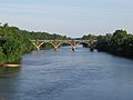
The RF&P Subdivision rail bridge over the Rappahannock River in 2017
-
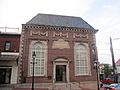
Fredericksburg Museum


See also
 In Spanish: Fredericksburg (Virginia) para niños
