
Freeland, Pennsylvania facts for kids
Quick facts for kids
Freeland, Pennsylvania
|
|
|---|---|
|
Borough
|
|

Borough building
|
|
| Nickname(s):
Freeport
|
|

Location of Freeland in Luzerne County, Pennsylvania
|
|

Freeland, Pennsylvania
Location in Pennsylvania

Freeland, Pennsylvania
Location in the United States
|
|
| Country | United States |
| State | Pennsylvania |
| County | Luzerne |
| Settled | 1844 |
| Incorporated | 1876 |
| Government | |
| • Type | Borough Council |
| Area | |
| • Total | 0.68 sq mi (1.75 km2) |
| • Land | 0.68 sq mi (1.75 km2) |
| • Water | 0.00 sq mi (0.00 km2) |
| Elevation | 1,943 ft (592 m) |
| Population
(2020)
|
|
| • Total | 3,833 |
| • Density | 5,072.59/sq mi (1,957.91/km2) |
| Time zone | UTC-5 (Eastern (EST)) |
| • Summer (DST) | UTC-4 (EDT) |
| ZIP code |
18224
|
| Area code(s) | 570 |
| FIPS code | 42-27744 |
Freeland is a borough in Luzerne County, Pennsylvania, United States. It was originally called Birbeckville, South Heberton, and Freehold. Freeland is 18 miles (29 km) south of Wilkes-Barre and 10 miles (16 km) northeast of Hazleton. It was incorporated as a borough on September 11, 1876. Coal mining was the chief industry in the community up until the mid-20th century. As of the 2020 census, the population was 3,833.
Contents
History
Pre-incorporation
Joseph Birkbeck, the founder of Birbeckville (not an actual name for the town of Freeland), was born near Brough under Stainmore, in the county of Westmorland, England, on May 2, 1802. He and his wife Elizabeth came to America in 1844. After acquiring land from Edward Lynch the same year of his arrival, Birkbeck built a log cabin in the region that is the small valley between Freeland and Upper Lehigh. The next settler, Nathan Howey, purchased land from Birkbeck and built a frame house just west of Birkbeck's log cabin.
Developing coal mines in the nearby region created a steep increase in population and a demand for building lots. This led Birkbeck to survey the region for the town of South Heberton. South Heberton has long since lost its identity and is now simply a cluster of houses along Schwabe Street which is now part of Freeland. Birkbeck's sawmill is at the turn of the road just east of Upper Lehigh, and what was mainly South Heberton is now known as Schwabe Street in Freeland which sits south of Upper Lehigh, a small mining town once owned by the Upper Lehigh company.

Between 1845 and 1846, Birkbeck cut the road now known as Buck Mountain Road through the woods from South Heberton through Eckley Miners' Village to Buck Mountain. Eckley was then known as Shingletown, as the chief industry there was the production of shingles.
The first child born at South Heberton was Elizabeth Birkbeck, the daughter of founder Joseph Birkbeck and his wife Elizabeth, in 1845. The first death at this place was that of William, the son of Joseph and Elizabeth Birkbeck, which occurred February 11, 1846. He was four years old at the time. The first store at South Heberton was kept by a man named Feist, which was just west of Birkbeck's cabin. Soon afterward another small store was run by a Mr. Mining. The first tavern was founded by N. Howey, the second settler of the region. Previous to the opening of Howey's tavern, Birkbeck accommodated parties who were prospecting in this region for anthracite deposits in his own home. A frame school was built in 1878, and by 1880 the population numbered 500.
Freeland was incorporated as a borough in 1876.
Post-incorporation
In 1883, the first Slovak Lutheran Church in America was organized in Freeland.
The population steadily grew due to the coal mining popularity and European immigration up until the mid-20th century. During the last few decades, Freeland's population has been declining while the median age has been rising and is now 42 years, four years higher than Pennsylvania's median age. This is mainly due to the decline of the coal industry, which was the sole appeal to new immigrants in the early 20th century.
Saint Mary's Ruthenian Catholic Church, in Freeland, is the mother parish of Byzantine-Ruthenian Catholic Churches in the United States.
For a detailed look at Freeland's history, visit the History of Freeland website: http://www.andrew.cmu.edu/user/ct0u/freeland.html
Present Day
As of 2017, Freeland has a YMCA Program, a community park, The Hazleton Area Public Library Freeland Branch and a remodeled Little League field. Also, there is a football/baseball field named "Della Croce Field" after Gene Della Croce, former Director of the Freeland YMCA. Along with the several parks and fields, several restaurants still remain in Freeland including The Other Side, Sorrento's Pizza, The Garlic Knot, and Garden Chen Chinese Food. A CVS Pharmacy is also located in the central part of Freeland.
Customs
Since a large demographic of people in Freeland are of Irish descent, every year, there is a St. Patrick's Day parade through downtown followed by a dinner. There are also annual events for Memorial Day and Veterans Day, due to the large amount of retired and active duty soldiers living in the surrounding areas. (Especially with the VFW and American Legion buildings being nearby). As part of the Memorial Day celebration, an annual Pub Run takes place, in which participants run a course with bars along the way. Participants must stop and finish a drink at each bar before continuing the race. The race usually consists of 9 bars throughout the borough, as well as some that do not technically fall within the municipal entity.
Geography
Freeland is located at 41°1′11″N 75°53′45″W / 41.01972°N 75.89583°W (41.019634, -75.895830).
According to the United States Census Bureau, the borough has a total area of 0.66 square miles (1.7 km2), all of it land.
Climate
The Köppen Climate Classification subtype for this climate is "Dfb" (Warm Summer Continental Climate).
| Climate data for Freeland, Pennsylvania | |||||||||||||
|---|---|---|---|---|---|---|---|---|---|---|---|---|---|
| Month | Jan | Feb | Mar | Apr | May | Jun | Jul | Aug | Sep | Oct | Nov | Dec | Year |
| Average high °C (°F) | 0 (32) |
0 (32) |
5 (41) |
12 (53) |
19 (66) |
23 (73) |
26 (78) |
24 (75) |
21 (69) |
15 (59) |
7 (44) |
1 (33) |
12 (53) |
| Average low °C (°F) | −9 (15) |
−8 (17) |
−4 (24) |
1 (33) |
7 (44) |
12 (53) |
15 (59) |
14 (57) |
10 (50) |
4 (39) |
0 (32) |
−6 (21) |
3 (37) |
| Average precipitation cm (inches) | 7.6 (3) |
7.4 (2.9) |
8.9 (3.5) |
10 (4.1) |
11 (4.4) |
12 (4.6) |
13 (5) |
11 (4.3) |
10 (4) |
9.4 (3.7) |
10 (4) |
8.9 (3.5) |
120 (47.1) |
| Source: Weatherbase | |||||||||||||
Demographics
| Historical population | |||
|---|---|---|---|
| Census | Pop. | %± | |
| 1880 | 624 | — | |
| 1890 | 1,730 | 177.2% | |
| 1900 | 5,254 | 203.7% | |
| 1910 | 6,197 | 17.9% | |
| 1920 | 6,666 | 7.6% | |
| 1930 | 7,098 | 6.5% | |
| 1940 | 6,593 | −7.1% | |
| 1950 | 5,909 | −10.4% | |
| 1960 | 5,068 | −14.2% | |
| 1970 | 4,784 | −5.6% | |
| 1980 | 4,285 | −10.4% | |
| 1990 | 3,909 | −8.8% | |
| 2000 | 3,643 | −6.8% | |
| 2010 | 3,531 | −3.1% | |
| 2020 | 3,833 | 8.6% | |
| Sources: | |||
As of the census of 2010, there were 3,531 people living in the borough, a decrease of 3.3% since the 2000 census. There were 1,760 housing units. The racial makeup of the borough was 95.78% White, 0.59% African American, 0.11% Native American, 0.54% Asian American, 1.53% from other races, and 1.44% mixed race. Hispanic or Latino Americans of any race were 5.81% of the population.
The main ancestries reported by white Freeland residents on the 2000 Census were Italian (17.5%), Polish (13.0%), Irish (12.3%), German (7.7%), and Slovak (6.6%).
There were 1,611 households, as of the 2000 Census, out of which 23.6% had children under the age of 18 living with them, 42.5% were married couples living together, 12.5% had a female householder with no husband present, and 39.9% were non-families. 37.1% of all households were made up of individuals, and 20.6% had someone living alone who was 65 years of age or older. The average household size in 2000 was 2.26 and the average family size was 2.96.
As of the 2010 Census, the population was spread out, with 23.22% under the age of 18, 5.83% from 20 to 24, 12.55% from 25 to 34, 19.12% from 35 to 49, 18.38% from 50 to 64, and 18.75% who were 65 years of age or older. The median age in 2000 was 42 years. As of 2010, for every 100 females there were 92.95 males. In 2000, for every 100 females age 18 and over, there were 82.7 males.
According to the Census of 2000, the median income for a household in the borough was $31,891, and the median income for a family was $40,863. Males had a median income of $31,631 versus $21,471 for females. The per capita income for the borough was $15,701. About 11.3% of families and 13.0% of the population were below the poverty line, including 18.6% of those under age 18 and 17.0% of those age 65 or over.
Education
Freeland is part of the Hazleton Area School District. Elementary and middle school students attend Freeland Elementary/Middle School. MMI Preparatory School, a college preparatory school for grades 6-12, is also located in Freeland.
Notable people
- Basil Schott, Byzantine Catholic bishop
Images for kids
-
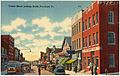
An old postcard of Freeland
-
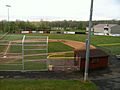
Little League field in Freeland
.jpg)

See also
 In Spanish: Freeland (Pensilvania) para niños
