
Frenchtown Charter Township, Michigan facts for kids
Quick facts for kids
Frenchtown Township, Michigan
|
|
|---|---|
|
Charter township
|
|
| Frenchtown Charter Township | |

Frenchtown Township Hall
|
|

Location within Monroe County and the administered communities of Detroit Beach (1), Stony Point (2), and Woodland Beach (3)
|
|

Frenchtown Township, Michigan
Location in Michigan

Frenchtown Township, Michigan
Location in the United States
|
|
| Country | United States |
| State | Michigan |
| County | Monroe |
| Settled | 1784 |
| Organized | 1837 |
| Area | |
| • Total | 43.12 sq mi (111.7 km2) |
| • Land | 41.82 sq mi (108.3 km2) |
| • Water | 1.30 sq mi (3.4 km2) |
| Elevation | 594 ft (181 m) |
| Population
(2010)
|
|
| • Total | 20,428 |
| • Density | 488.5/sq mi (188.6/km2) |
| Time zone | UTC-5 (Eastern (EST)) |
| • Summer (DST) | UTC-4 (EDT) |
| ZIP code(s) | |
| Area code | 734 |
| FIPS code | 26-30820 |
| GNIS feature ID | 1626321 |
Frenchtown Charter Township is a charter township within Monroe County in the U.S. state of Michigan. The population was 20,428 at the 2010 census.
The township is bordered on the south by the city of Monroe. Sterling State Park and the Enrico Fermi Nuclear Generating Station are located within Frenchtown, and the township was the site of the Battle of Frenchtown during the War of 1812.
Communities
- Baycrest Beach is a lakefront unincorporated community along Lake Erie at 41°56′41″N 83°18′28″W / 41.94472°N 83.30778°W.
- Detroit Beach is the most populated of the township's communities at 41°55′53″N 83°19′50″W / 41.93139°N 83.33056°W. Although an unincorporated community, it is a census-designated place with a population of 2,289 at the 2000 Census.
- Golfcrest is an unincorporated community located just west of Interstate 75 at 41°56′33″N 83°22′17″W / 41.94250°N 83.37139°W. Vivian Road is the main street through the community, and it also contains several smaller side streets leading up to the larger Cole Road.
- Kimberly Estates is the township's largest trailer park. It is located at 41°59′25″N 83°22′06″W / 41.99028°N 83.36833°W in the northwestern portion of the township along U.S. Route 24 and Grafton Road.
- Newport is a large unincorporated community centered at 42°00′08″N 83°18′31″W / 42.00222°N 83.30861°W mostly in Berlin Charter Township, although it has portions extending into Frenchtown. As an unincorporated area, Newport has no legal boundaries or demographic statistics of its own. Newport contains its own post office, which serves most of Berlin. The Enrico Fermi Nuclear Generating Station is within the Frenchtown portion of Newport.
- Sterling State Park is a small unincorporated community located at 41°55′39″N 83°20′49″W / 41.92750°N 83.34694°W. It is bordered on the east by Sterling State Park.
- Stony Point is an unincorporated community located at 41°56′28″N 83°15′58″W / 41.94111°N 83.26611°W. It closely connected to Pointe Aux Peaux Farms just south of the Enrico Fermi Nuclear Generating Station. It is classified as a census-designated place with a population of 1,775 at the 2000 Census.
- Woodland Beach is a large lakefront unincorporated community located at 41°56′32″N 83°19′06″W / 41.94222°N 83.31833°W. It is bordered on the south by Grand Beach and to the north by Erie Shores. Woodland Beach is classified as a census-designated place with a population of 2,179 at the 2000 Census.
History
This area was long occupied by Native Americans, including the historic Potawatomi. The Frenchtown area was settled by Europeans along the banks of the River Raisin in as early as 1784 by French Canadians, whose descendants are known as Muskrat French. Around the same time, the Sandy Creek Settlement was established near the main settlement of Frenchtown by Joseph Porlier Benec. This area became part of the United States after the Treaty of Paris (1783), specifically and sequentially part of the Northwest Territory (1787), Indiana Territory (1803), Michigan Territory (1805), and, finally, the State of Michigan (1837).
During the War of 1812, the area was the site of the Battle of Frenchtown, in which 397 Americans were killed by the British Army and Native American coalition; this was the highest number of American fatalities of any battle during the war. The battlefield site today is within the River Raisin National Battlefield Park, which was designated in 2009 and falls within the present-day city limits of Monroe.
That area of Frenchtown township was renamed and incorporated in 1817 as the village of Monroe in honor of then-President James Monroe's future visit to the Michigan Territory later that year. In the same year, the city of Monroe was named as the county seat of the newly created Monroe County. Monroe re-incorporated as a city in 1837. When that happened, the remaining area known as Frenchtown was reorganized as a township, encompassing much of the northern portion of the county — the area from the River Raisin to the Huron River at Wayne County's southern border. Shortly after, the northern portion of the township was broken off to form Ash Township and Berlin Charter Township by 1867. In addition to that, pieces of the southern portion of Frenchtown have been annexed by the city of Monroe on many occasions. Because of that, the boundary between the current Frenchtown Charter Township and the city limits of Monroe is jagged.
Geography
According to the United States Census Bureau, the township has a total area of 43.2 square miles (112 km2) of land and 1.1 square miles (2.8 km2) of water. The township is bordered on the east by Lake Erie, and many of the township’s communities are located near the lake. Sterling State Park is located along the southern edge of the township and is the only of Michigan’s 98 state parks located on or near Lake Erie. Small pieces of the township are also organized into the Detroit River International Wildlife Refuge. Frenchtown Charter Township is bordered on the south by the city of Monroe, but a small portion of the southern border touches Monroe Charter Township. Raisinville Township is to the west, and Ash and Berlin Charter Townships border on the north. A very small portion of the northwest corner of Frenchtown Charter Township touches Exeter Township. The River Raisin serves as the boundary between Frenchtown and the city of Monroe for a short length near Lake Erie and then again further upstream for a small portion near the Custer Airport. Sandy Creek also runs through Frenchtown before ending in Lake Erie. Frenchtown Charter Township, as well as the rest of the county, is at the lowest elevation in the state of Michigan at 571 feet (174 m) above sea level at Lake Erie.
Interstate 75 passes through Frenchtown Charter Township, and the southern terminus of Interstate 275 is at Interstate 75 in the extreme northern portion of the township. U.S. Highway 24 (US 24, Telegraph Road) and M-125 (North Monroe Street) pass through the township as well.
Frenchtown Charter Township is served by one area code (734) and three zip codes: 48162, 48166, and 48117. The majority of the township is served by 48162 (which also serves a portion of the city of Monroe), while the area to the north near Newport falls into 48166. A very small portion in the northwest corner near the terminus of M-125 at US 24 is within 48117. No portion of Frenchtown Charter Township falls within 48161, used primarily for Monroe and Monroe Charter Township, as the boundary between 48161 and 48162 is the River Raisin; no portion of the township is south of the River Raisin.
Demographics
As of the census of 2010, there were 20,428 people, 7,733 households, and 5,598 families residing in the township. The population density was 493.4 per square mile (190.5/km2). There were 8,244 housing units at an average density of 195.8 per square mile (75.6/km2). The racial makeup of the township was 95.51% White, 1.59% African American, 0.41% Native American, 0.53% Asian, 0.01% Pacific Islander, 0.45% from other races, and 1.49% from two or more races. Hispanic or Latino of any race were 2.45% of the population.
There were 7,733 households, out of which 35.9% had children under the age of 18 living with them, 56.1% were married couples living together, 11.0% had a female householder with no husband present, and 27.6% were non-families. 22.4% of all households were made up of individuals, and 8.0% had someone living alone who was 65 years of age or older. The average household size was 2.65 and the average family size was 3.10.
In the township the population was spread out, with 27.5% under the age of 18, 9.4% from 18 to 24, 31.5% from 25 to 44, 21.5% from 45 to 64, and 10.1% who were 65 years of age or older. The median age was 34 years. For every 100 females there were 99.9 males. For every 100 females age 18 and over, there were 95.6 males.
The median income for a household in the township was $47,699, and the median income for a family was $54,032. Males had a median income of $44,338 versus $25,787 for females. The per capita income for the township was $21,335. About 4.9% of families and 7.0% of the population were below the poverty line, including 6.4% of those under age 18 and 8.7% of those age 65 or over.
Images for kids
-
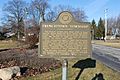
Frenchtown Township historical marker
-
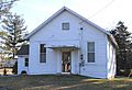
Vivian Library and former town hall, 1910
-
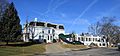
Monroe Golf & Country Club, 1919
-
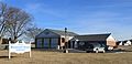
Bluebush Road Library & Fire Station No. 3


See also
 In Spanish: Municipio de Frenchtown (condado de Monroe, Míchigan) para niños
