
Fulton County, Illinois facts for kids
Quick facts for kids
Fulton County
|
|
|---|---|

The old courthouse columns at Oak Hill Cemetery
|
|

Location within the U.S. state of Illinois
|
|
 Illinois's location within the U.S. |
|
| Country | |
| State | |
| Founded | 1823 |
| Named for | Robert Fulton |
| Seat | Lewistown |
| Largest city | Canton |
| Area | |
| • Total | 883 sq mi (2,290 km2) |
| • Land | 866 sq mi (2,240 km2) |
| • Water | 17 sq mi (40 km2) 1.9% |
| Population
(2010)
|
|
| • Total | 37,069 |
| • Estimate
(2018)
|
34,844 |
| • Density | 41.981/sq mi (16.209/km2) |
| Time zone | UTC−6 (Central) |
| • Summer (DST) | UTC−5 (CDT) |
| Congressional district | 17th |
Fulton County is a county in the U.S. state of Illinois. According to the 2010 census, it had a population of 37,069. Its county seat is Lewistown, and the largest city is Canton. Fulton County comprises the Canton, IL Micropolitan Statistical Area, which is part of the Peoria-Canton, IL Combined Statistical Area.
Patrick O'Brian is the Chairman of the Fulton County Board. Mike Hays was the County Administrator until the position was eliminated.
The current Miss Fulton County (2019) is Alexandra Chamberlin of Canton, IL.
Contents
History
Fulton County was organized in 1823 from Pike County. It is named for Robert Fulton, inventor of the steamboat. It was the home of famous poet/writer Edgar Lee Masters in his early days; he wrote the famous Spoon River Anthology (1915). Fulton County was home to Camp Ellis during World War II.
The county is known for the annual Spoon River Scenic Drive which occurs the first 2 weekends in October. This has been a tradition since 1968 and attracts thousands of participants from all over the country.
-
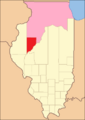
Fulton County between 1823 and 1825, including a large tract of unorganized territory temporarily attached.
-
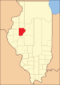
Fulton County in 1825, reduced to its current size, its unorganized territory formed into new counties.


Geography
According to the U.S. Census Bureau, the county has a total area of 883 square miles (2,290 km2), of which 866 square miles (2,240 km2) is land and 17 square miles (44 km2) (1.9%) is water.
Fulton County is the site of Dickson Mounds Museum, a state museum of Native American daily life in the Illinois River valley.
Climate and weather
| Weather chart for Lewistown, Illinois | |||||||||||||||||||||||||||||||||||||||||||||||
|---|---|---|---|---|---|---|---|---|---|---|---|---|---|---|---|---|---|---|---|---|---|---|---|---|---|---|---|---|---|---|---|---|---|---|---|---|---|---|---|---|---|---|---|---|---|---|---|
| J | F | M | A | M | J | J | A | S | O | N | D | ||||||||||||||||||||||||||||||||||||
|
1.9
32
14
|
1.9
38
19
|
3
50
30
|
3.5
63
40
|
4.4
74
51
|
3.8
84
60
|
3.9
88
64
|
3.5
86
61
|
3.2
80
52
|
2.9
68
41
|
3.3
51
30
|
2.6
37
19
|
||||||||||||||||||||||||||||||||||||
| temperatures in °F precipitation totals in inches source: The Weather Channel |
|||||||||||||||||||||||||||||||||||||||||||||||
|
Metric conversion
|
|||||||||||||||||||||||||||||||||||||||||||||||
In recent years, average temperatures in the county seat of Lewistown have ranged from a low of 14 °F (−10 °C) in January to a high of 88 °F (31 °C) in July, although a record low of −30 °F (−34 °C) was recorded in January 1999 and a record high of 106 °F (41 °C) was recorded in July 1983. Average monthly precipitation ranged from 1.85 inches (47 mm) in January to 4.43 inches (113 mm) in May.
Adjacent counties
- Knox County - north
- Peoria County - northeast
- Tazewell County - east
- Mason County - south
- Schuyler County - southwest
- McDonough County - west
- Warren County - northwest
National protected area
Transportation
Major highways
 US Route 24
 US Route 136
 Illinois Route 9
 Illinois Route 41
 Illinois Route 78
 Illinois Route 95
 Illinois Route 97
 Illinois Route 100
 Illinois Route 116
Airport
The county contains one public-use airport: Ingersoll Airport (CTK), located in Canton.
Demographics
| Historical population | |||
|---|---|---|---|
| Census | Pop. | %± | |
| 1830 | 1,841 | — | |
| 1840 | 13,142 | 613.9% | |
| 1850 | 22,508 | 71.3% | |
| 1860 | 33,338 | 48.1% | |
| 1870 | 38,291 | 14.9% | |
| 1880 | 41,240 | 7.7% | |
| 1890 | 43,110 | 4.5% | |
| 1900 | 46,201 | 7.2% | |
| 1910 | 49,549 | 7.2% | |
| 1920 | 48,163 | −2.8% | |
| 1930 | 43,983 | −8.7% | |
| 1940 | 44,627 | 1.5% | |
| 1950 | 43,716 | −2.0% | |
| 1960 | 41,954 | −4.0% | |
| 1970 | 41,890 | −0.2% | |
| 1980 | 43,687 | 4.3% | |
| 1990 | 38,080 | −12.8% | |
| 2000 | 38,250 | 0.4% | |
| 2010 | 37,069 | −3.1% | |
| 2018 (est.) | 34,844 | −6.0% | |
| US Decennial Census 1790-1960 1900-1990 1990-2000 2010-2013 |
|||

As of the 2010 United States Census, there were 37,069 people, 14,536 households, and 9,744 families residing in the county. The population density was 42.8 inhabitants per square mile (16.5/km2). There were 16,195 housing units at an average density of 18.7 per square mile (7.2/km2). The racial makeup of the county was 93.4% white, 3.4% black or African American, 0.4% American Indian, 0.3% Asian, 1.6% from other races, and 0.9% from two or more races. Those of Hispanic or Latino origin made up 2.4% of the population. In terms of ancestry, 23.7% were German, 19.1% were American, 14.0% were English, and 13.2% were Irish.
Of the 14,536 households, 29.3% had children under the age of 18 living with them, 52.0% were married couples living together, 10.2% had a female householder with no husband present, 33.0% were non-families, and 28.1% of all households were made up of individuals. The average household size was 2.37 and the average family size was 2.86. The median age was 41.9 years.
The median income for a household in the county was $41,268 and the median income for a family was $50,596. Males had a median income of $41,376 versus $28,596 for females. The per capita income for the county was $20,309. About 9.9% of families and 13.8% of the population were below the poverty line, including 22.2% of those under age 18 and 8.0% of those age 65 or over.
Communities
Cities
Villages
Unincorporated communities
Townships
Fulton County is divided into twenty-six townships:
- Astoria
- Banner
- Bernadotte
- Buckheart
- Canton
- Cass
- Deerfield
- Ellisville
- Fairview
- Farmers
- Farmington
- Harris
- Isabel
- Joshua
- Kerton
- Lee
- Lewistown
- Liverpool
- Orion
- Pleasant
- Putman
- Union
- Vermont
- Waterford
- Woodland
- Young Hickory
See also
 In Spanish: Condado de Fulton (Illinois) para niños
