
Fulton County, Ohio facts for kids
Quick facts for kids
Fulton County
|
||
|---|---|---|

|
||
|
||

Location within the U.S. state of Ohio
|
||
 Ohio's location within the U.S. |
||
| Country | ||
| State | ||
| Founded | April 1, 1850 | |
| Named for | Robert Fulton | |
| Seat | Wauseon | |
| Largest city | Wauseon | |
| Area | ||
| • Total | 407 sq mi (1,050 km2) | |
| • Land | 405 sq mi (1,050 km2) | |
| • Water | 1.8 sq mi (5 km2) 0.4%% | |
| Population
(2020)
|
||
| • Total | 42,713 | |
| • Density | 104.95/sq mi (40.52/km2) | |
| Time zone | UTC−5 (Eastern) | |
| • Summer (DST) | UTC−4 (EDT) | |
| Congressional district | 5th | |


Fulton County is a county located in the U.S. state of Ohio west of Toledo. As of the 2020 census, the population was 42,713. Its county seat is Wauseon. The county was created in 1850 with land from Henry, Lucas, and Williams counties and is named for Robert Fulton, inventor of the steamboat. Fulton County is part of the Toledo Metropolitan Area.
Contents
History
The first seat of justice in Fulton County was Ottokee, located there because of its central location in the county. A wooden courthouse was built in 1851.
However, a railroad was built further south. Wauseon sprung up in 1854 when the railroad was extended to that point, and incorporated in 1859. With the commercial success that the railroad brought to Wauseon, the citizens of the county voted to move the county seat to Wauseon in 1871. The Fulton County Courthouse was built in 1872.
-
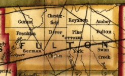
1851 Railroad map: Ottokee is the county seat of justice.
-
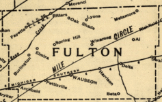
1890 Railroad map: Wauseon is now the county seat.


Geography

Fulton County is part of the Toledo Metropolitan Area.
According to the U.S. Census Bureau, the county has a total area of 407 square miles (1,050 km2), of which 405 square miles (1,050 km2) is land and 1.8 square miles (4.7 km2) (0.4%) is water.
Adjacent counties
- Lenawee County, Michigan (north)
- Lucas County (east)
- Henry County (south)
- Williams County (west)
- Hillsdale County, Michigan (northwest)
Protected Areas
- Fulton Pond Wildlife Area
- Goll Woods State Nature Preserve
- Harrison Lake State Park
- Maumee State Forest
- Tiffin River Wildlife Area
- Wabash Cannonball Trail
Demographics
| Historical population | |||
|---|---|---|---|
| Census | Pop. | %± | |
| 1850 | 7,781 | — | |
| 1860 | 14,043 | 80.5% | |
| 1870 | 17,789 | 26.7% | |
| 1880 | 21,053 | 18.3% | |
| 1890 | 22,023 | 4.6% | |
| 1900 | 22,801 | 3.5% | |
| 1910 | 23,914 | 4.9% | |
| 1920 | 23,445 | −2.0% | |
| 1930 | 23,477 | 0.1% | |
| 1940 | 23,626 | 0.6% | |
| 1950 | 25,580 | 8.3% | |
| 1960 | 29,301 | 14.5% | |
| 1970 | 33,071 | 12.9% | |
| 1980 | 37,751 | 14.2% | |
| 1990 | 38,498 | 2.0% | |
| 2000 | 42,084 | 9.3% | |
| 2010 | 42,698 | 1.5% | |
| 2020 | 42,713 | 0.0% | |
| U.S. Decennial Census 1790-1960 1900-1990 1990-2000 2020 |
|||
2010 census
As of the 2010 United States Census, there were 42,698 people, 16,188 households, and 11,942 families living in the county. The population density was 105.3 inhabitants per square mile (40.7/km2). There were 17,407 housing units at an average density of 42.9 per square mile (16.6/km2). The racial makeup of the county was 94.9% white, 0.4% black or African American, 0.4% Asian, 0.3% American Indian, 2.4% from other races, and 1.5% from two or more races. Those of Hispanic or Latino origin made up 7.8% of the population. In terms of ancestry, 45.5% were German, 11.9% were Irish, 10.7% were English, 6.9% were Polish, and 6.2% were American.
Of the 16,188 households, 34.6% had children under the age of 18 living with them, 59.8% were married couples living together, 9.3% had a female householder with no husband present, 26.2% were non-families, and 22.3% of all households were made up of individuals. The average household size was 2.61 and the average family size was 3.05. The median age was 39.9 years.
The median income for a household in the county was $50,717 and the median income for a family was $59,090. Males had a median income of $42,561 versus $30,070 for females. The per capita income for the county was $22,804. About 8.5% of families and 10.5% of the population were below the poverty line, including 14.4% of those under age 18 and 5.4% of those age 65 or over.
Transportation
Airport
Fulton County Airport is a public use airport located four nautical miles (5 mi, 7 km) north of the central business district of Wauseon, Ohio. It is owned by the Fulton County Commissioners.
Highways
 Ohio Turnpike
 I-80
I-80 I-90
I-90
 US 20
US 20 US 20A
 US 127
 SR 2
SR 2 SR 64
SR 64 SR 66
SR 66 SR 108
 SR 109
 SR 120
Communities

City
- Wauseon (county seat)
Villages
Townships
- Amboy
- Chesterfield
- Clinton
- Dover
- Franklin
- Fulton
- German
- Gorham
- Pike
- Royalton
- Swan Creek
- York
Census-designated places
Unincorporated communities
See also
 In Spanish: Condado de Fulton (Ohio) para niños
