
Gadsden County, Florida facts for kids
Quick facts for kids
Gadsden County
|
||
|---|---|---|
.jpg)
Gadsden County Courthouse
|
||
|
||

Location within the U.S. state of Florida
|
||
 Florida's location within the U.S. |
||
| Country | ||
| State | ||
| Founded | June 24, 1823 | |
| Named for | James Gadsden | |
| Seat | Quincy | |
| Largest city | Quincy | |
| Area | ||
| • Total | 529 sq mi (1,370 km2) | |
| • Land | 516 sq mi (1,340 km2) | |
| • Water | 12 sq mi (30 km2) 2.3%% | |
| Population
(2020)
|
||
| • Total | 43,826 | |
| • Density | 82.85/sq mi (31.987/km2) | |
| Time zone | UTC−5 (Eastern) | |
| • Summer (DST) | UTC−4 (EDT) | |
| Congressional district | 5th | |

Gadsden County is a county located in the panhandle of the U.S. state of Florida. As of the 2020 census, the population was 43,826. Its county seat is Quincy.
Gadsden County is included in the Tallahassee, FL Metropolitan Statistical Area.
Gadsden County is the only majority (over 50%) African-American county in Florida.
Contents
History
Gadsden County was created in 1823. It was named for James Gadsden of South Carolina, who served as Andrew Jackson's aide-de-camp in Florida in 1818. Gadsden County is historically known for its tobacco crop which is obsolete today.
Geography
According to the U.S. Census Bureau, the county has a total area of 529 square miles (1,370 km2), of which 516 square miles (1,340 km2) is land and 12 square miles (31 km2) (2.3%) is water.
Gadsden County is part of the Tallahassee Metropolitan Statistical Area. Gadsden County is in the Eastern Time Zone. Its western border with Jackson County forms the boundary in this area between the Eastern and Central Time Zones.
Adjacent counties
- Decatur County, Georgia - north
- Seminole County, Georgia - north
- Grady County, Georgia - northeast
- Leon County, Florida - east
- Liberty County, Florida - southwest
- Calhoun County, Florida - southwest (CST)
- Jackson County, Florida - northwest (CST)
Demographics
| Historical population | |||
|---|---|---|---|
| Census | Pop. | %± | |
| 1830 | 4,895 | — | |
| 1840 | 5,992 | 22.4% | |
| 1850 | 8,784 | 46.6% | |
| 1860 | 9,396 | 7.0% | |
| 1870 | 9,802 | 4.3% | |
| 1880 | 12,169 | 24.1% | |
| 1890 | 11,894 | −2.3% | |
| 1900 | 15,294 | 28.6% | |
| 1910 | 22,198 | 45.1% | |
| 1920 | 23,539 | 6.0% | |
| 1930 | 29,890 | 27.0% | |
| 1940 | 31,450 | 5.2% | |
| 1950 | 36,457 | 15.9% | |
| 1960 | 41,989 | 15.2% | |
| 1970 | 39,184 | −6.7% | |
| 1980 | 41,565 | 6.1% | |
| 1990 | 41,105 | −1.1% | |
| 2000 | 45,087 | 9.7% | |
| 2010 | 46,389 | 2.9% | |
| 2020 | 43,826 | −5.5% | |
| U.S. Decennial Census 1790-1960 1900-1990 1990-2000 2010-2020 |
|||
2020 census
| Race / Ethnicity | Pop 2010 | Pop 2020 | % 2010 | % 2020 |
|---|---|---|---|---|
| White alone (NH) | 15,335 | 14,093 | 33.06% | 32.16% |
| Black or African American alone (NH) | 25,881 | 23,326 | 55.79% | 53.22% |
| Native American or Alaska Native alone (NH) | 93 | 71 | 0.20% | 0.16% |
| Asian alone (NH) | 221 | 147 | 0.48% | 0.34% |
| Pacific Islander alone (NH) | 7 | 4 | 0.02% | 0.01% |
| Some Other Race alone (NH) | 39 | 120 | 0.08% | 0.27% |
| Mixed Race/Multi-Racial (NH) | 394 | 972 | 0.85% | 2.22% |
| Hispanic or Latino (any race) | 4,419 | 5,093 | 9.53% | 11.62% |
| Total | 46,389 | 43,826 | 100.00% | 100.00% |
Note: the US Census treats Hispanic/Latino as an ethnic category. This table excludes Latinos from the racial categories and assigns them to a separate category. Hispanics/Latinos can be of any race.
Gadsden County is unique in Florida in that it is the state's only county with an African American majority population.
2010 Census
As of the 2010 United States Census, there were 46,389 people living in the county. 56.0% were Black or African American, 35.9% White, 0.5% Asian, 0.3% Native American, 5.9% of some other race and 1.3% of two or more races. 9.5% were Hispanic or Latino (of any race).
As of the census of 2000, there were 45,087 people, 15,867 households, and 11,424 families living in the county. The population density was 87 people per square mile (34/km2). There were 17,703 housing units at an average density of 34 per square mile (13/km2). The racial makeup of the county was 57.14% Black or African American, 38.70% White, 0.23% Native American, 0.26% Asian, 0.02% Pacific Islander, 2.76% from other races, and 0.89% from two or more races. 6.17% of the population were Hispanic or Latino of any race.
There were 15,867 households, out of which 32.60% had children under the age of 18 living with them, 44.50% were married couples living together, 22.50% had a female householder with no husband present, and 28.00% were non-families. 23.90% of all households were made up of individuals, and 9.50% had someone living alone who was 65 years of age or older. The average household size was 2.69 and the average family size was 3.18.
In the county, the population was spread out, with 26.40% under the age of 18, 9.50% from 18 to 24, 28.90% from 25 to 44, 23.00% from 45 to 64, and 12.20% who were 65 years of age or older. The median age was 36 years. For every 100 females, there were 90.70 males. For every 100 females age 18 and over, there were 86.50 males.
The median income for a household in the county was $31,248, and the median income for a family was $36,238. Males had a median income of $27,159 versus $21,721 for females. The per capita income for the county was $14,499. About 16.40% of families and 19.90% of the population were below the poverty line, including 28.50% of those under age 18 and 16.90% of those age 65 or over.
Transportation
Airports
- Quincy Municipal Airport
Major roads

 Interstate 10 is the main west-to-east interstate highway in the county, and serves as the unofficial dividing line between northern and southern Gadsden County. It contains four interchanges within the county; CR 270A (Exit 166), SR 12 (Exit 174), SR 267 (Exit 181), and US 90 (Exit 192).
 US 90 was the main west-to-east highway in the county prior to the construction of I-10 in the late 1960s. It runs from the Victory Bridge in Chatahoochee in the northwest, and then southeast through Gretna, Douglas City, and Quincy before finally leaving the county east of Midway into Leon County.
 US 27 is the sole south-to-north U.S. highway running through the northeastern part of the county.
 State Road 12 is a west-to-east state highway running from Liberty County in the southwest to Havana in the northeast. It also contains a county extension into Leon County.
 State Road 65
 State Road 159 is a short south to north road connecting US 27 to SR 12 in Havana, with a county extension northwest to Georgia State Route 309 at the Georgia State Line.
 State Road 267
Railroads
Gadsden County has at least four existing railroad lines, three of which are owned by CSX. The first two CSX lines being P&A Subdivision, a line formerly owned by the Louisville and Nashville Railroad, and the other is the Tallahassee Subdivision, a former Seaboard Air Line Railroad line. These two lines meet in Chatahoochee and served Amtrak's Sunset Limited until it was truncated to New Orleans in 2005 by Hurricane Katrina. A third line is the Apalachicola Northern Railroad, a line that spans as far south as Port St. Joe. The line enters from Liberty County, then crosses SR 12 in Greensboro, runs under I-10, follows CR 268 in Hardaway, and then turns west into Chatahoochee. The fourth line is the third CSX Line, the Bainbridge Subdivision, which runs along the west side of US 27 from Leon County by way of a bridge over the Ochlockonee River to the Georgia State Line. While some spurs still exist, other lines within the county were abandoned.
Public transportation
Public Transportation is provided by Big Bend Transit, which operates 3 bus routes in the county.
Communities
Cities
Towns
Education

The Gadsden County School District operates public schools.
Gadsden County is home to one public high school, Gadsden County High School (formerly East Gadsden High School), formed in 2017 by the merger of East Gadsden High and the high school portion of West Gadsden High School; the West Gadsden High building was converted to West Gadsden Middle. West Gadsden was formed by the merger of the former Chattahoochee High and Greensboro High and was located on the western outskirts of Quincy near Greensboro. East Gadsden, formed by the merger of James A. Shanks High and Havana Northside High, was located on Hwy. 90 east of Quincy.
Robert F. Munroe Day School and Tallavanna Christian School are private schools in the county that were founded as segregation academies.
Libraries
The Gadsden County Public Library System has 3 branches.
- William A. McGill Library
- Havana Branch
- Chattahoochee Branch
Images for kids
-
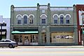
Gadsden County Board of Commissioners
-
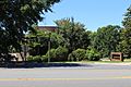
Gadsden County Sheriff's Office
-
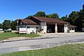
Gadsden County Emergency Medical Services and Gadsden County Fire Services


See also
 In Spanish: Condado de Gadsden para niños
