
Geography of Australia facts for kids
Quick facts for kids Geography of Australia |
|
|---|---|
 |
|
| Continent | Australia |
| Region | Oceania |
| Coordinates | 27°00′00″S 144°00′00″E / 27.000°S 144.000°E |
| Area | Ranked 6th |
| • Total | 7,686,850 km2 (2,967,910 sq mi) |
| • Land | 98.21% |
| • Water | 1.79% |
| Coastline | 59,681 km (37,084 mi) |
| Borders | None |
| Highest point | Mount Kosciuszko 2,228 m (7,310 ft) |
| Lowest point | Lake Eyre, −15 m (−49 ft) |
| Longest river | Murray River, 2,375 km (1,476 mi) |
| Largest lake | Lake Eyre 9,500 km2 (3,668 sq mi) |
| Climate | Mostly desert or semi-arid, south-east and south-west corners: temperate, north: tropical climate, varied between tropical rainforests, grasslands, part desert, mountainous areas: subantarctic tundra |
| Terrain | Mostly low plateau with deserts, rangelands and a fertile plain in the southeast; mountain ranges in the east and south-east. |
| Natural Resources | Minerals, coal, and timber |
| Natural Hazards | Cyclones along the northern coasts, severe thunderstorms, droughts, occasional floods, heat waves, and frequent bushfires |
The geography of Australia encompasses a wide variety of biogeographic regions being the world's smallest continent, while comprising the territory of the sixth-largest country in the world. The population of Australia is concentrated along the eastern and south-eastern coasts. The geography of the continent is extremely diverse, ranging from the snow-capped mountains of the Australian Alps and Tasmania to large deserts, tropical and temperate forests, grasslands, heathlands and woodlands.
The countries that govern nearby regions include Indonesia, East Timor, and Papua New Guinea to the north; the Solomon Islands, Vanuatu, and the French dependency of New Caledonia to the east; and New Zealand to the southeast.
Contents
Physical geography

_(Oceania_centered).svg)
Australia is a country, and a continent. It is located in Oceania between the Indian Ocean and the South Pacific Ocean. It is the sixth largest country in the world with a total area of 7,686,850 square kilometres (2,967,910 sq mi) (including Lord Howe Island and Macquarie Island), making it slightly smaller than the 48 states of the contiguous United States and 31.5 times larger than the United Kingdom.
The Australian mainland has a total coastline length of 35,877 km (22,293 mi) with an additional 23,859 km (14,825 mi) of island coastlines. There are 758 estuaries around the country with most located in the tropical and sub-tropical zones. Australia claims an extensive Exclusive Economic Zone of 8,148,250 square kilometres (3,146,057 sq. mi). This exclusive economic zone does not include the Australian Antarctic Territory.
Australia has the largest area of ocean jurisdiction of any country on earth. It has no land borders. The northernmost points of the country are the Cape York Peninsula of Queensland and the Top End of the Northern Territory. The western half of Australia consists of the Western Plateau, which rises to mountain heights near the west coast and falls to lower elevations near the continental centre. The Western Plateau region is generally flat, though broken by various mountain ranges such as the Hamersley Range, the MacDonnell Ranges, and the Musgrave Range. Surface water is generally lacking in the Western Plateau, although there are several larger rivers in the west and north, such as the Murchison, Ashburton, and Victoria river.
The Eastern Highlands, or Great Dividing Range, lie near the eastern coast of Australia, separating the relatively narrow eastern coastal plain from the rest of the continent. These Eastern Australian temperate forests have the greatest relief, the most rainfall, the most abundant and varied flora and fauna, and the densest human settlement.
Between the Eastern Highlands and the Western Plateau, lie the Central Lowlands, which are made up of the Great Artesian Basin and Australia's largest river systems, Murray-Darling Basin and Lake Eyre Basin.
Off the eastern coast of Australia is the world's largest coral reef complex, the Great Barrier Reef. The State of Tasmania, a large and mountainous island, resides in the south-eastern corner of Australia.
Geology

Australia is the lowest, flattest, and oldest continental landmass on Earth and it has had a relatively stable geological history. Geological forces such as tectonic uplift of mountain ranges or clashes between tectonic plates occurred mainly in Australia's early history, when it was still a part of Gondwana. Its highest peak is Mount Kosciuszko at 2,228 metres (7,310 ft), which is relatively low in comparison to the highest mountains on other continents. Erosion has heavily weathered Australia's surface.
Australia is situated in the middle of the tectonic plate, and therefore currently has no active volcanism. Minor earthquakes which produce no damage occur regularly, while major earthquakes measuring greater than magnitude 6 occur on average every five years. The terrain is mostly low plateau with deserts, rangelands and a fertile plain in the southeast. Tasmania and the Australian Alps do not contain any permanent icefields or glaciers, although they may have existed in the past. The Great Barrier Reef, by far the world's largest coral reef, lies a short distance off the north-east coast.
Regions

The Australian continental landmass consists of 6 distinct landform divisions. These are:
- The Eastern Highlands—including the Great Dividing Range, the fertile Brigalow Belt strip of grassland behind the east coast, and the Eastern Uplands
- The Eastern alluvial Plains and Lowlands—Murray Darling basin covers southern part, also includes parts of the Lake Eyre Basin and extends to the Gulf of Carpentaria
- The South Australian Highlands—including the Flinders Range, Eyre Peninsula and Yorke Peninsula
- The Western Plateau—including the Nullarbor Plain
- The Central Deserts
- Northern Plateau and Basins—including the Top End
Hydrology

Because much of Australia's interior is arid, the low average annual rainfall means interior rivers are often dry and lakes empty. The headwaters of some waterways are located in tropical regions where summer rains create a high rate of discharge. Flood events drastically alter the dry environment in which the ecology of central Australia has had to adapt to the boom and bust cycle.
The Great Artesian Basin is an important source of water, the world's largest and deepest fresh water basin. Access to water from the basin has led to the expansion of grazing into areas that were previously far too dry for livestock. Towns and cities across the country sometimes face major water storage and usage crisis in which restrictions and other measures are implemented to reduce water consumption. Water restrictions are based on a gradient of activities that become progressively banned as the situation worsens.
Billabong is the Australian name given to the oxbow lakes that can form along a meandering river's course. In a worldwide comparison of height, Australia's waterfalls are relatively insignificant, with the longest drop ranked 135th according to the World Waterfall Database.
Political geography
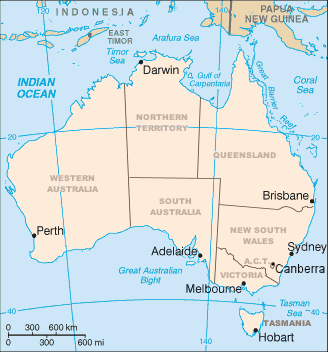
Australia consists of six states, two major mainland territories, and other minor territories. The states are New South Wales, Queensland, South Australia, Tasmania, Victoria and Western Australia. The two major mainland territories are the Northern Territory and the Australian Capital Territory. Western Australia is the largest state covering just under one third of the Australian landmass, followed by Queensland, South Australia and New South Wales.
Australia also has several minor territories; the federal government administers a separate area within New South Wales, the Jervis Bay Territory, as a naval base and sea port for the national capital. In addition Australia has the following, inhabited, external territories: Norfolk Island, Christmas Island, Cocos (Keeling) Islands, and several largely uninhabited external territories: Ashmore and Cartier Islands, Coral Sea Islands, Heard Island and McDonald Islands and the Australian Antarctic Territory.
Climate

By far the largest part of Australia is arid or semi-arid. A total of 18% of Australia's mainland consists of named deserts, while additional areas are considered to have a desert climate based on low rainfall and high temperature. Only the south-east and south-west corners have a temperate climate and moderately fertile soil. The northern part of the country has a tropical climate: part is tropical rainforests, part grasslands, and part desert.
Rainfall is highly variable, with frequent droughts lasting several seasons thought to be caused in part by the El Niño-Southern Oscillation. Occasionally a dust storm will blanket a region or even several states and there are reports of the occasional large tornado. Rising levels of salinity and desertification in some areas is ravaging the landscape.
Australia's tropical/subtropical location and cold waters off the western coast make most of western Australia a hot desert with aridity, a marked feature of the greater part of the continent. These cold waters produce little moisture needed on the mainland. A 2005 study by Australian and American researchers investigated the desertification of the interior, and suggested that one explanation was related to human settlers who arrived about 50,000 years ago. Regular burning by these settlers could have prevented monsoons from reaching interior Australia. The outback covers 70 percent of the continent.
Natural hazards
Cyclones along the northern coasts, severe thunderstorms, droughts, occasional floods, heat waves, and frequent bushfires are natural hazards that are present in Australia.
Antipodes
Australia is antipodal to the North Atlantic. There are no land areas included, though Bermuda has its antipodes just off Perth, Flores Island in the western Azores just off Flinders Island, Tasmania, and Cape Verde is opposite the Coral Sea.
Images for kids
-
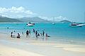
Whitehaven Beach in Queensland in October
-
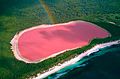
Lake Hillier, a saline lake on the edge of Middle Island off the south coast of Western Australia
-
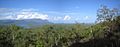
Tropical forest, grassland and mountain ranges in Queensland
-
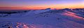
Mount Kosciuszko in the Alps of southeastern Australia
-
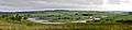
Megalong Valley in the temperate Blue Mountains region of New South Wales


See also
 In Spanish: Geografía de Australia para niños
