
Geography of California facts for kids


California is a U.S. state on the western coast of North America. It is bordered by Oregon in the north, Nevada and Arizona on its east, and Mexico in the south. The Pacific Ocean makes up the entire west coast of California. It is among the most geographically diverse states covering an area of 163,696 sq mi (423,970 km2). It is home to the world's tallest (coast redwood), most massive (Giant Sequoia), and oldest (bristlecone pine) trees. It is also home to both the highest (Mount Whitney) and lowest (Death Valley) points in the 48 contiguous states.
Contents
Northern California
Northern California usually refers to the state's northernmost 48 counties. The large cities in Northern California include San Francisco, Oakland, San Jose, and Sacramento (the state capital).
The Klamath Mountains are a mountain range in northwest California and southwest Oregon. Their highest peak is Mount Eddy in Trinity County, California, at 9,037 feet (2,754 m). The climate is cold winters with heavy snowfall and warm dry summers with limited rainfall.
The Cascade Range is a mountainous region stretching from the Fraser River in British Columbia, Canada, down to the south of Lassen Peak, California. The Cascades (as they are called for short) are part of the Pacific Ring of Fire, the ring of volcanoes around the Pacific Ocean. Mount Shasta (the second-highest peak in the Cascade Range after Mount Rainier in Washington) is located in the Cascades.

The Modoc Plateau lies in the northeast corner of the state. The plateau lies between the Cascade Range to the west and the Warner Mountains to the east. Nine percent of the plateau is protected as reserves or wilderness areas, such as the Modoc National Wildlife Refuge.
In the east of the state lies the Sierra Nevada, which runs north-south for 400 miles (640 km). The highest peak in the contiguous United States, Mount Whitney at 14,505 feet (4,421 m), lies within the Sierra Nevada. The famous Yosemite Valley is also located in the Central Sierra. The large, deep freshwater Lake Tahoe lies to the North of Yosemite. The Sierra is also home to the Giant Sequoia, the most massive trees on Earth. The most famous hiking and horse-packing trail in the Sierra is the John Muir Trail, which goes from the top of Mt. Whitney to Yosemite Valley. It is part of the Pacific Crest Trail that goes from Mexico to Canada. The famous Yosemite National Park, Kings Canyon National Park, and Sequoia National Parks are in this province.
The Basin and Range geological province extends east into Nevada. Mono Lake, which is the oldest lake in North America, is located there. The salt sediments of many lake beds in the Basin and Range has been mined for many years. This is most famously true for Owens Lake and Death Valley. The White Mountains, which are home to the oldest living organism in the world, the bristlecone pine, are in the province.
California's central feature is the Central Valley, a huge, fertile valley between the coastal mountain ranges and the Sierra Nevada. The whole Central Valley is watered by mountain-fed rivers. The rivers are large and deep enough that they allow seaports in several cities away from the coast.
The Coast Ranges lie to the west of the Central Valley. The Coast Ranges north of San Francisco become increasingly foggy and rainy. These mountains contain coast redwoods, the tallest trees on earth, which live within the range of the coastal fog.
Southern California
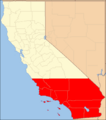
The term Southern California usually refers to the ten southernmost counties of the state. Another definition for Southern California uses the Tehachapi Mountains as the northern boundary. Southern California has a more urban environment. It is home to some of the largest cities in the state. Some of these cities include Los Angeles, Orange County, San Diego, and Riverside-San Bernardino. About 60% of California's population lives in Southern California. Southern California is known for industries including the film industry, residential construction, entertainment industry, and military aerospace. It is possible to surf in the Pacific Ocean and ski on a mountain during the same winter day in Southern California.

Southern California is separated from the rest of the state by the mountains that run east to west called the Transverse Ranges. They range eastward from the Pacific coast and run about halfway across the state.
The Mojave Desert is located in southeast California and extends eastward into Nevada and Arizona. The Mojave Desert receives less than 6 inches (150 mm) of rain a year and is generally between 3,000 and 6,000 feet (1,000 and 2,000 m) of elevation. It also contains the lowest, hottest place in the Americas: Death Valley.
The southernmost mountains of California are the Peninsular Ranges. They run ast of San Diego and continue into Baja California (in Mexico).
The Colorado and Sonoran Deserts lie east of the Peninsular Ranges. They extend into Arizona and Mexico. Calipatria, California, which is the lowest-elevation community, is 160 feet (49 m) below sea level.
The Channel Islands are a group of islands off the coast of Southern California. They are divided into two groups, the Northern Channel Islands and the Southern Channel Islands. There are eight islands in total:

| Northern islands | Southern islands |
| Anacapa Island | San Clemente Island |
| San Miguel Island | San Nicolas Island |
| Santa Cruz Island | Santa Barbara Island |
| Santa Rosa Island | Santa Catalina Island |
Pacific Ocean
The Pacific Ocean lies to the west of California. The water temperature is cooler even in summer, rarely getting warmer than 65 °F (18 °C). The sea off California is green and filled with fish.
Geology
Faults, tsunamis, and volcanoes
Earthquakes occur due to faults that run the length of the Pacific coast. The largest and most famous fault is the San Andreas Fault. Here is a list of the major historical earthquakes and their magnitudes:
- 1906 San Francisco earthquake (magnitude 7.8–8.2)
- 1971 San Fernando earthquake (magnitude 6.6)
- 1989 Loma Prieta earthquake (magnitude 6.9–7.1)
- 1994 Northridge earthquake (magnitude 6.7)
Cities along the coast of California are at risk of having a tsunami destroy the coastline. Earthquakes nearby and elsewhere in the Pacific Ring of Fire quickly move the sea floor and cause these giant, fast-moving waves.
California is also home to several volcanoes, including Lassen Peak, which erupted in 1914 and 1921, and Mount Shasta.
Climate

California is one of the only U.S. states that can have snow and summer weather at the same time. Southern parts of the state with a lower elevation have a desert climate while the northern part can be subarctic. Coastal and Southern parts have a Mediterranean climate, with somewhat rainy winters and dry summers. The ocean helps areas near the coast have warmer winters and cooler summers.
Floods are occasionally caused by heavy rain, storms, and snowmelt. Steep slopes and unstable soil make certain locations vulnerable to landslides in wet weather or during earthquakes.
Interesting facts about the geography of California
- Both the highest and lowest elevations in the Continental United States are in California, only 80 miles apart. The tallest mountain peak is Mount Whitney at 14,496 feet; the lowest elevation in California and North America is in Death Valley at 282 feet below sea level.
- Hazards in California can consist of earthquake shaking and fault movement, tsunamis, landslides, volcanic eruptions, floods, and exposure to hazardous minerals.
- The longest fault in California is the San Andreas Fault system.
- There are more than 700 named faults in California that are recently active. Many other recently active faults are still unnamed.
- Approximately 100 earthquakes occur in California daily, though most of them are too small in magnitude to feel.
- Fossils of mammoths, dogs, bears, cats, horses, camels, antelope, bison, sheep, turtles, shellfish, flamingos and palm trees have been found in sedimentary rocks in Southern California near Barstow.
- Tsunamis that affect California are typically caused by earthquakes and fault movement that occur under the ocean, both off the coast of California and elsewhere in the world.
- Fumaroles (vents of volcanic gas and steam) found near Lassen Peak are evidence of recent and ongoing volcanic activity.
- Pillow basalts, like those found in the Coast Ranges, were formed when molten lava cooled under the ocean in shapes resembling the size and shape of a pillow.
- California’s state mineral is gold. The Gold Rush of 1849 caused a rush of settlers and led to California becoming the 31st state in 1850.
Images for kids
-
Southern California

See also
 In Spanish: Geografía de California para niños
