
Germantown (town), New York facts for kids
Quick facts for kids
Germantown, New York
|
|
|---|---|

Town hall, 2013
|
|

Location of Germantown, New York
|
|
| Country | |
| State | |
| County | |
| Established | 1788 |
| Government | |
| • Type | Town Council |
| Area | |
| • Total | 13.9 sq mi (36.1 km2) |
| • Land | 12.1 sq mi (31.3 km2) |
| • Water | 1.8 sq mi (4.7 km2) |
| Elevation | 249 ft (76 m) |
| Population
(2020)
|
|
| • Total | 1,936 |
| • Density | 160/sq mi (61.9/km2) |
| Time zone | UTC-5 (Eastern (EST)) |
| • Summer (DST) | UTC-4 (EDT) |
| ZIP code |
12526
|
| Area code(s) | 518 Exchange: 537 |
| FIPS code | 36-28772 |
| GNIS feature ID | 0978998 |
Germantown is a town in Columbia County, New York, United States. The population was 1,936 at the 2020 census, down slightly from 1,954 in 2010. Germantown is located in the southwestern part of the county, along the east side of the Hudson River.
Contents
History
The first known inhabitants of the area were the Mahican. The first Europeans to buy property in the county were Dutch. Robert Livingston, a Scots immigrant, bought thousands of acres from the Native Americans, before gaining a huge grant from the Crown. He owned a total of 160,240 acres (64,850 ha). He was made lord of the Livingston Manor. In 1710, he sold 6,000 acres (2,400 ha) of his property to Anne, Queen of Great Britain, for use as work camps and resettlement of Palatine German refugees.
Some 1,200 persons were settled at work camps to manufacture naval stores and pay off their passage as indentured labor. Known as "East Camp", the colony had four villages: Hunterstown, Queensbury, Annsbury, and Haysbury. The area was later renamed "Germantown". In 1775 Germantown was formed as a "district". Germantown was one of the seven original towns of Columbia County established by an act passed March 7, 1788. (The others were: Kinderhook, Canaan, Claverack, Hillsdale, Clermont, and Livingston).
In March 1845, a boat-load of people from East Camp, who had been to Hudson to make purchases, was run over first by a scow, and then by the steamboat South America. All nine individuals were lost.
The Barringer–Overbaugh–Lasher House, Clermont Manor, Clermont Estates Historic District, Charles H. Coons Farm, Dick House, German Reformed Sanctity Church Parsonage, Hudson River Heritage Historic District, Stone Jug, and Simeon Rockefeller House are listed on the National Register of Historic Places.
Geography
According to the United States Census Bureau, the town has a total area of 13.9 square miles (36.1 km2), of which 12.1 square miles (31.3 km2) is land and 1.8 square miles (4.7 km2), or 13.07%, is water. The west town line, marking the center of the Hudson River, is the border of Greene and Ulster counties.
Demographics
| Historical population | |||
|---|---|---|---|
| Census | Pop. | %± | |
| 1820 | 891 | — | |
| 1830 | 967 | 8.5% | |
| 1840 | 969 | 0.2% | |
| 1850 | 1,023 | 5.6% | |
| 1860 | 1,353 | 32.3% | |
| 1870 | 1,393 | 3.0% | |
| 1880 | 1,608 | 15.4% | |
| 1890 | 1,683 | 4.7% | |
| 1900 | 1,686 | 0.2% | |
| 1910 | 1,649 | −2.2% | |
| 1920 | 1,424 | −13.6% | |
| 1930 | 1,462 | 2.7% | |
| 1940 | 1,427 | −2.4% | |
| 1950 | 1,418 | −0.6% | |
| 1960 | 1,504 | 6.1% | |
| 1970 | 1,782 | 18.5% | |
| 1980 | 1,922 | 7.9% | |
| 1990 | 2,010 | 4.6% | |
| 2000 | 2,018 | 0.4% | |
| 2010 | 1,954 | −3.2% | |
| 2020 | 1,936 | −0.9% | |
| U.S. Decennial Census | |||
As of the census of 2000, there were 2,018 people, 831 households, and 546 families residing in the town. The population density was 166.0 people per square mile (64.1/km2). There were 984 housing units at an average density of 81.0 per square mile (31.3/km2). The racial makeup of the town was 96.93% White, 1.14% Black or African American, 0.15% Native American, 0.45% Asian, 0.40% from other races, and 0.94% from two or more races. Hispanic or Latino of any race were 1.29% of the population.
There were 831 households, out of which 28.3% had children under the age of 18 living with them, 53.7% were married couples living together, 7.5% had a female householder with no husband present, and 34.2% were non-families. 28.8% of all households were made up of individuals, and 14.0% had someone living alone who was 65 years of age or older. The average household size was 2.41 and the average family size was 2.95.
In the town, the population was spread out, with 23.1% under the age of 18, 6.0% from 18 to 24, 27.1% from 25 to 44, 25.8% from 45 to 64, and 18.1% who were 65 years of age or older. The median age was 42 years. For every 100 females, there were 94.4 males. For every 100 females age 18 and over, there were 95.5 males.
The median income for a household in the town was $42,195, and the median income for a family was $50,885. Males had a median income of $36,806 versus $26,250 for females. The per capita income for the town was $22,198. About 5.0% of families and 7.9% of the population were below the poverty line, including 9.3% of those under age 18 and 5.7% of those age 65 or over.
Communities and locations in Germantown
- Cheviot – A hamlet near the Hudson River, south of Germantown hamlet.
- Germantown – The hamlet of Germantown is located near the Hudson River on Route 9G.
- North Germantown – A hamlet on Route 9G north of Germantown hamlet.
- Palatine Park – A park northeast of Germantown hamlet.
- Viewmont – A hamlet on the south town line.
Notable people
- Corbin Bernsen, actor
- Dow Hover, New York State executioner
- Amanda Pays, actor, interior designer (one of many homes)
- Sonny Rollins, saxophonist
- Oliver Stone, film director
Images for kids
-
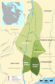
Traditional Mohican, Housatonic, Wappinger, and Wawyachtonoc territory at one point within the area currently known as the Hudson River Valley
-
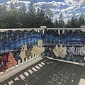
The Germantown library's summer 2021 yarn storming focused on the importance of coral reefs to the planet's ecosystem.
-
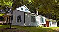
Barringer-Overbaugh-Lasher House
-
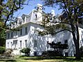
Livingston family mansion at the Clermont State Historic Site
-
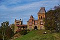
The grounds of Olana are 7 miles north of Germantown
-
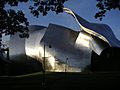
Richard B. Fisher Center for the Performing Arts at Bard


See also
 In Spanish: Germantown (pueblo) para niños
