
Gers facts for kids
Quick facts for kids
Gers
|
|||
|---|---|---|---|

Prefecture building of the Gers department, in Auch
|
|||
|
|||

Location of Gers in France
|
|||
| Country | France | ||
| Region | Occitanie | ||
| Département | 4 March 1790 | ||
| Prefecture | Auch | ||
| Area | |||
| • Total | 6,256.8 km2 (2,415.8 sq mi) | ||
| Population
(2014)
|
|||
| • Total | 190,625 | ||
| • Density | 30.4669/km2 (78.9088/sq mi) | ||
| Demonym(s) | Gersois | ||
| Time zone | UTC+1 (CET) | ||
| • Summer (DST) | UTC+2 (CEST) | ||
| ISO 3166 code | FR-32 | ||
| Arrondissements | 3 | ||
| Cantons | 17 | ||
| Communes | 462 | ||
| Website | www.gers.fr/ | ||


Gers (Gascon: Gers) is a department in the Occitanie region in the southwest of France named after the Gers river.
Contents
History
Gers is one of the 83 French departments made during the French revolution, on 4 March 1790. It was created from parts of the old provinces of Guyenne and Gascony.
The capital (now prefecture) was Auch.
in 1808, part of the Gers department was transferred to the new Tarn-et-Garonne department'.
Geography

Gers is known for its hilly landscape and bastide villages. The Pyrenees are visible to the south.
Gers is part of the Occitanie region, and is the 34th French department in area with 6,256.8 km2 (2,416 sq mi).
The department is surrounded by six departments in two regions:
- Nouvelle-Aquitaine region
- Lot-et-Garonne (north)
- Pyrénées-Atlantiques (southwest)
- Landes (west)
- Occitanie region
- Tarn-et-Garonne (northeast)
- Haute-Garonne (east)
- Hautes-Pyrénées (south)
 |
Lot-et-Garonne | Tarn-et-Garonne | |
|
| Landes | Haute-Garonne | |||
| Pyrénées-Atlantiques | Hautes-Pyrénées |
The main rivers of the department are the Garonne and the Gers, a left tributary of the Garonne. Other rivers are Save, Gimone, Arrats, Baïse and Osse.
The highest point in the department is Mont de Chapelle Saint Roch (43°21′20″N 00°30′09″E / 43.35556°N 0.50250°E), in west central Pyrénées near the border with the Hautes-Pyrénées department, with an altitude of 377 m (1,237 ft).
Climate
The climate of Gers is an oceanic climate with template summers, Cfb (Marine West Coast Climate) in the Köppen climate classification.
The annual rainfall in the department varies from over 900 mm (35.4 in) in the southwest of the department, to less than 700 mm (27.6 in) in the northeast.
Summers are very hot and dry, the temperatures often exceed 40 °C (104 °F). Winters vary, often with frost, but the climate remains mild and dry.
| Climate data for Auch, Gers, France | |||||||||||||
|---|---|---|---|---|---|---|---|---|---|---|---|---|---|
| Month | Jan | Feb | Mar | Apr | May | Jun | Jul | Aug | Sep | Oct | Nov | Dec | Year |
| Average high °C (°F) | 10.2 (50.4) |
11.8 (53.2) |
15.1 (59.2) |
17.6 (63.7) |
21.5 (70.7) |
25.3 (77.5) |
27.9 (82.2) |
27.9 (82.2) |
24.9 (76.8) |
19.9 (67.8) |
13.7 (56.7) |
10.4 (50.7) |
18.9 (65.9) |
| Daily mean °C (°F) | 5.9 (42.6) |
6.8 (44.2) |
9.5 (49.1) |
11.9 (53.4) |
15.8 (60.4) |
19.4 (66.9) |
21.6 (70.9) |
21.4 (70.5) |
18.5 (65.3) |
14.5 (58.1) |
9.3 (48.7) |
6.3 (43.3) |
13.4 (56.1) |
| Average low °C (°F) | 1.5 (34.7) |
1.7 (35.1) |
3.9 (39.0) |
6.2 (43.2) |
10 (50) |
13.4 (56.1) |
15.2 (59.4) |
14.9 (58.8) |
12 (54) |
9.1 (48.4) |
4.8 (40.6) |
2.1 (35.8) |
7.9 (46.3) |
| Average rainfall mm (inches) | 40.3 (1.59) |
31.6 (1.24) |
37.8 (1.49) |
61.4 (2.42) |
84.6 (3.33) |
68.4 (2.69) |
58.8 (2.31) |
64.3 (2.53) |
75 (3.0) |
72.1 (2.84) |
54.6 (2.15) |
43.1 (1.70) |
692 (27.29) |
| Source: Weatherbase.com [1] | |||||||||||||
Administration
The department is managed by the Departamental Council of the Gers in Auch. Gers is part of the region of Occitanie.
Demographics
The inhabitants of Gers are known, in French, as Gersois (women: Gersoises).
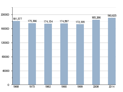
Gers has a population, in 2014, of 190,625, for a population density of 30.5 inhabitants/km2.
Evolution of the population in Gers

Economy
The economy in Gers revolves primarily around agriculture and culinary tourism. The department is a producer of maize, wheat, rapeseed, sunflower.
Some well-known products of the region are:
- Armagnac, a brandy
- Côtes de Gascogne, wine
- Floc de Gascogne, an apéritif (an alcoholic drink served before a meal)
- Foie gras
- Wild mushrooms
Gallery


.JPG)
Related pages
- Arrondissements of the Gers department
- Communes of the Gers department
Images for kids
-
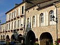
Montréal, Gers
-
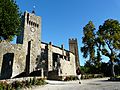
Larressingle
-
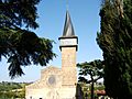
Barran


See also
 In Spanish: Gers (departamento) para niños
