
Gibson County, Indiana facts for kids
Quick facts for kids
Gibson County
|
|
|---|---|

SE face of the Gibson County Courthouse in Princeton (built 1884) and the Civil War monument (1912)
|
|

Location within the U.S. state of Indiana
|
|
 Indiana's location within the U.S. |
|
| Country | |
| State | |
| Founded | 1 April 1813 |
| Named for | John Gibson |
| Seat | Princeton |
| Largest city | Princeton |
| Area | |
| • Total | 499.16 sq mi (1,292.8 km2) |
| • Land | 487.49 sq mi (1,262.6 km2) |
| • Water | 11.68 sq mi (30.3 km2) 2.34% |
| Population | |
| • Estimate
(2018)
|
33,452 |
| • Density | 68.6/sq mi (26.5/km2) |
| Time zone | UTC−6 (Central) |
| • Summer (DST) | UTC−5 (CDT) |
| Congressional district | 8th |
|
|
Gibson County is a county in the southwestern part of the U.S. state of Indiana. As of the 2010 United States Census, the population was 33,503. The county seat is Princeton.
Contents
History
From 1790 to 1813, this area was part of Knox County, Indiana. The first white settler of what became Gibson County was John Severns, a native of Wales who had come with his parents to North America several years before the Revolutionary War. He settled in Gibson County in 1789-90 on the south bank of the Patoka River at a place now known as Severns Bridge. Another early Gibson County settler was William Hargrove, who came from Kentucky by pack mule in 1803; Captain Hargrove commanded a company of militia from Gibson County at the Battle of Tippecanoe in 1811.

The Rev. Joseph Milburn, along with his son, Robert Milburn, also arrived in 1803. They settled near Princeton, between the Patoka and White Rivers. The Milburns were from the area of Washington County, Kentucky. Rev. Milburn, a Baptist, established the first church; Robert established the first distillery in Indiana.
In 1805, Jacob Warrick arrived, along with his father-in-law, Thomas Montgomery. They burned out the last Native American village in 1807, chasing the inhabitants into the Illinois Territory. Captain Warrick was killed at the Battle of Tippecanoe in 1811.
Gibson and Warrick Counties were organized in 1813 out of Knox County. Gibson County was named for John Gibson, an officer in the French and Indian War and the Revolutionary War. Gibson was Secretary of the Indiana Territory, serving as acting Governor on two occasions. The two counties of Gibson County and Warrick County, separated by Rector's Base Line, were formed March 9, 1813 and organized on April 1, 1813. Gibson County occupied everything from the Wabash River and from the White River's extension to the Paoli Base Line down the 2d Principal Meridian to the Rector's Base Line. The area south of this line became Warrick County, which covered the area from the 2d Principal Meridian west to the Wabash River and down the Wabash River and with meanders up the Ohio River back to the 2d Principal Meridian (which had previously separated Knox County from Harrison County, Indiana Territory). Orange County, Spencer County, Pike County, Dubois County, and Crawford County all came from the roughly 2,000-square-mile (5,200 km2) area occupied by the original Gibson County, as well as small portions of Lawrence County, Perry County, Posey County, the current Warrick County, and Vanderburgh County.
When the county was organized, Patoka was initially intended to be the county seat. However, Patoka's low-lying location along the Patoka River gave rise to a malaria epidemic; to avoid this, the commissioners chose to establish a new town, eventually known as Princeton, on higher ground approximately 4 miles (6 km) south. However, although Princeton contends that it was the only county seat, some contend that county records indicate that Owensville was a temporary county seat since Princeton was not even laid out until late 1814, at least a year after Gibson County's organization.
Geography


Gibson County is the northern third of the Evansville, Indiana–Kentucky Metropolitan Statistical Area. Nearly 90% of the county exists within the Ohio River Valley American Viticultural Area along with all of neighboring Posey, Vanderburgh and Warrick counties and a portion of Pike County. Despite being close to Evansville and experiencing a large growth of population in the central areas, Gibson County still remains a largely rural county with half of the ten townships having populations less than 2,000. Less than 7 percent of the county's 500 square miles (1,300 km2) lies within incorporated settlements, or 10 percent if subdivisions are included.
The western part of the county consists largely of spread-out flood-prone farms with spotty marshes along the Wabash and White Rivers. There are rolling hills around Owensville, and large forest and marshland tracts lie near the Gibson Generating Station and the three river settlements of Crawleyville, East Mount Carmel, and Skelton. The northern part is near the White River and is more given to hills and forest. The eastern part contains many hills and is also dotted with strip pits and active coal mines. The southern part is more given to valley and marshland, drained by the Pigeon Creek which flows south through Evansville.
Even without Interstate 69, the county is within a day's drive of Chicago, Cincinnati, Chattanooga, Columbus, Indianapolis, Louisville, Memphis, Nashville, Springfield, St. Louis, even South Bend, and Fort Wayne despite the lack of freeway connection. There are two major intersections in the southern extremes of the county. One is the intersection of Interstate 64 and US 41. The other is between Interstate 64 and Interstate 69, which will eventually link the county and Evansville to Indianapolis and Memphis and make a day trip to even Detroit possible.
The western half of the Patoka River National Wildlife Refuge and Management Area lies within Gibson County.
According to the 2010 census, the county has a total area of 499.16 square miles (1,292.8 km2), of which 487.49 square miles (1,262.6 km2) (or 97.66%) is land and 11.68 square miles (30.3 km2) (or 2.34%) is water.
Adjacent counties
|
|
Cities
|
|
Towns
|
|
|

Unincorporated communities
|
|
|
* Baldwin Heights and Northbrook Hills are within the city limits of Princeton.
Townships
Gibson County consists of ten townships:
|
|
|
|
|
Two townships, Wabash and Washington, contain no incorporated towns.
Climate and weather
| Weather chart for Princeton, Indiana | |||||||||||||||||||||||||||||||||||||||||||||||
|---|---|---|---|---|---|---|---|---|---|---|---|---|---|---|---|---|---|---|---|---|---|---|---|---|---|---|---|---|---|---|---|---|---|---|---|---|---|---|---|---|---|---|---|---|---|---|---|
| J | F | M | A | M | J | J | A | S | O | N | D | ||||||||||||||||||||||||||||||||||||
|
2.9
38
21
|
3
44
26
|
4.2
55
35
|
4.5
66
45
|
5.1
76
55
|
3.9
84
64
|
3.9
88
67
|
4.1
86
65
|
3.2
79
58
|
3.2
68
46
|
4.4
54
36
|
3.6
42
26
|
||||||||||||||||||||||||||||||||||||
| temperatures in °F precipitation totals in inches source: The Weather Channel |
|||||||||||||||||||||||||||||||||||||||||||||||
|
Metric conversion
|
|||||||||||||||||||||||||||||||||||||||||||||||
In recent years, average temperatures in Princeton have ranged from a low of 21 °F (−6 °C) in January to a high of 88 °F (31 °C) in July, although a record low of −19 °F (−28 °C) was recorded in January 1985 and a record high of 113 °F (45 °C) was recorded in July 1936. Average monthly precipitation ranged from 2.90 inches (74 mm) in January to 5.11 inches (130 mm) in May.
Demographics
| Historical population | |||
|---|---|---|---|
| Census | Pop. | %± | |
| 1830 | 6,192 | — | |
| 1840 | 6,280 | 1.4% | |
| 1850 | 6,403 | 2.0% | |
| 1860 | 7,855 | 22.7% | |
| 1870 | 7,939 | 1.1% | |
| 1880 | 8,282 | 4.3% | |
| 1890 | 11,156 | 34.7% | |
| 1900 | 11,227 | 0.6% | |
| 1910 | 13,661 | 21.7% | |
| 1920 | 18,061 | 32.2% | |
| 1930 | 19,666 | 8.9% | |
| 1940 | 23,926 | 21.7% | |
| 1950 | 27,777 | 16.1% | |
| 1960 | 28,567 | 2.8% | |
| 1970 | 28,799 | 0.8% | |
| 1980 | 29,233 | 1.5% | |
| 1990 | 30,159 | 3.2% | |
| 2000 | 32,580 | 8.0% | |
| 2010 | 33,503 | 2.8% | |
| 2015 (est.) | 33,775 | 0.8% | |
| U.S. Decennial Census 1790-1960 1900-1990 1990-2000 2010-2013 |
|||
As of the 2010 United States Census, there were 33,503 people, 13,255 households, and 9,168 families residing in the county. The population density was 68.7 inhabitants per square mile (26.5/km2). There were 14,645 housing units at an average density of 30.0 per square mile (11.6/km2). The racial makeup of the county was 95.5% white, 1.8% black or African American, 0.5% Asian, 0.2% American Indian, 0.5% from other races, and 1.6% from two or more races. Those of Hispanic or Latino origin made up 1.3% of the population. In terms of ancestry, 28.3% were German, 24.3% were American, 13.1% were Irish, and 11.7% were English.
Of the 13,255 households, 32.3% had children under the age of 18 living with them, 55.0% were married couples living together, 9.7% had a female householder with no husband present, 30.8% were non-families, and 26.5% of all households were made up of individuals. The average household size was 2.47 and the average family size was 2.98. The median age was 39.9 years.
The median income for a household in the county was $47,697 and the median income for a family was $61,652. Males had a median income of $43,271 versus $28,424 for females. The per capita income for the county was $22,542. About 7.6% of families and 12.2% of the population were below the poverty line, including 16.1% of those under age 18 and 9.8% of those age 65 or over.
Recent disasters
2004 snowstorm
In the holiday season of 2004, a crippling snowstorm dumped over twice the normal annual snowfall in three days. Accumulations averaged 20 inches in Gibson County, with snow drifts reaching over 4 feet (1.2 m) in spots and some spots of Gibson County receiving as much as 32 inches (0.81 m). Interstate 64 was closed down. The Indiana National Guard was dispatched and local farmers were recruited to assist in emergency services for stranded motorists.
2005 flood
The White River at Hazleton got as high as 31 feet (9.4 m), almost high enough to overtake US 41, Extreme flooding occurred throughout the county and hundreds of local high school students from many counties assisted the Indiana National Guard in shoring up levees and sandbagging towns. Hazleton was evacuated because its levee was showing signs of fatigue. All of the levees held. By the end of January 2005, the rivers had receded enough to allow people to return to their homes. Over 100 homes were lost in the flood, which was considered the second-worst flood in the area's history (after the Great Flood of 1913).
2008 earthquake
The 2008 Illinois earthquake was one of the largest earthquakes recorded in Illinois, measuring a magnitude of 5.2. It occurred at 4:37:00 a.m. CDT (9:37:00 UTC) on April 18 within the Wabash Valley Seismic Zone at a depth of 11.6 km. It was centered near West Salem, Illinois and Mount Carmel, Illinois, specifically at 38.450° N, 87.890° W.
2008 flood
A major flood occurred in June 2008. It was caused by intense rainfall and the source of the flood was entirely upstream. Both the Wabash and White Rivers were severely flooded and nearly all of Gibson County's levees held the flood back, while many levees upstream were failing.
2017 Tornado
On the evening of February 28, 2017, a powerful and extremely violent EF3 tornado struck areas of southern Illinois and Southwest Indiana, the tornado began near Crossville, IL where it caused one death, the tornado then continued northeast, crossing the Wabash River into Posey County, IN where it caused mainly tree and relatively minor structure damage, the tornado then continued it's track east-northeast into southern Gibson County where the most intense damage occurred just north of the Posey County line, 2 people received minor injuries there, the tornado continued, causing damage along the way, until ending near Oakland City, IN after tracking 44 miles.
Transportation

County roads
Gibson County has over 1,700 miles (2,700 km) of county roads, one of the largest amounts of county-maintained roads outside of an urban county. Like most Indiana counties, Gibson County uses the Indiana county road system to identify its roads. U.S. Route 41 (a north–south road) and State Road 64 (an east–west road) are near the meridian and division lines for the county, respectively.
Major highways
 I-64
I-64 I-69
I-69 US 41
US 41 SR 56
SR 56 SR 57
SR 57 SR 64
SR 64 SR 65
SR 65 SR 68
SR 68 SR 165
 SR 168
 SR 357

Interstate 69
A section of Interstate 69's construction groundbreaking occurred on July 16, 2008, at the Centre in Evansville. This project has its controversy, highlighted by a group of protesters in attendance. A portion of the first segment opened in September 2009. The entire stretch of highway in Gibson County was open to traffic on November 15, 2012.
Railroads
Three railroad lines pass through the county. CSX Transportation operates a north–south line, and Norfolk Southern Railway operates an east–west line; they intersect in Princeton. A north–south Indiana Southern Railroad line intersects the Norfolk Southern line at Oakland City.
Recreation
- Gibson County Fairgrounds - Princeton - site of Indiana's oldest county fair, started in 1852.
- Azalea Path Arboretum and Botanical Gardens (Located South of Mt Olympus on the Gibson/Pike County Line)
- Oakland City New Lake - Oakland City
- Lafayette Park - Princeton
- Gil Hodges Field - Princeton
- Camp Carson YMCA Campground - Princeton
- Haubstadt Old School Park and Old Gym - Haubstadt
- Tri-State Speedway - Haubstadt
- Weather Rock Campground - Warrenton
- Montgomery Park - Owensville
- REH Center (Old Owensville Gym) - Owensville
- Gibson Lake - Owensville
- Marlette Park - Fort Branch
- Old Gym - Fort Branch
- City Park of Fort Branch
- Gibson Southern High School Grounds - Fort Branch
- Patoka River National Wildlife Refuge and Management Area - Francisco and Oakland City
- Hemmer Woods State Nature Preserve - Southeast of Mackey
Sports
Gibson County's association with baseball is far-reaching with noted Major League Baseball players and announcers such as Gary Denbo and Dave Niehaus, and most notably MLB hall of famer Edd Roush and MLB legend Gil Hodges, the namesake of Gil Hodges Field, a little league field in Princeton.
Gibson County made its mark on the High School scene with two softball titles by Gibson Southern and a double overtime Boys Basketball State Title by Princeton in 2009, completing a 29–0 season as well as PCHS now holding the All-time points record with Jackie Young as of 2016 and a 2015 Girls Basketball State Title. In addition there are three State Runner-Up Titles. All of these titles have been acquired since Gibson Southern's Softball Runner-Up Title in 2001.
Education

Gibson County's three municipal school districts
East Gibson School Corporation – Oakland City:
- Waldo J. Wood Memorial Jr/Sr High School – Oakland City (Trojans)
- Oakland City Elementary School – Oakland City (Acorns)
- Francisco Elementary School – Francisco (Owls)
- Barton Township School – Mackey (Aces)

North Gibson School Corporation – Princeton:
- Princeton Community High School – Princeton (Tigers)
- Princeton Community Middle School – Princeton (Tigers)
- Brumfield Elementary School (formerly the "Early Learning Center") – Princeton (Tiger Cubs)
South Gibson School Corporation – Fort Branch:

- Gibson Southern High School – Fort Branch (Titans)
- Fort Branch Community School (K-8) – Fort Branch (Twigs)
- Haubstadt Community School (K-8) – Haubstadt (Elites)
- Owensville Community School (K-8) – Owensville (Kickapoos)
Private education
Gibson County's Private Education consists of four Catholic Schools run by the Roman Catholic Diocese of Evansville and one non-Catholic Christian school. Holy Cross, St. James, and Bethel field basketball teams. Enrollment and Grades are in the 1st parentheses. Mascot (I/A) is in 2nd parentheses.
- Bethel Christian School – Princeton (K3-8:112) (Crusaders)
- Holy Cross Catholic School – Fort Branch (K-5:111) (Crusaders)
- St. James Catholic School – St. James/Haubstadt (K-8:185) (Cougars)
- St. Joseph Catholic School – Princeton (K-5:185)
- St.s Peter & Paul Catholic School – Haubstadt (K-5:200)
Higher education
- Oakland City University – Oakland City, Private university
- Vincennes University Workforce Training Center – Princeton Branch – On southwest corner of Gibson County Courthouse
- Ivy Tech Campus – 2 miles (3.2 km) south of Princeton, soon to be within city limits in upcoming annexation.
- Vincennes University Center for Advanced Manufacturing – located near Fort Branch Community School at U.S. 41 and Coal Mine Road (CR 800 South). Groundbreaking was on October 23, 2009, with Construction starting on November 3, 2009. Workforce programs offered at the Gibson County Center include certified miner safety training and heavy equipment operator training. In February 2016, in cooperation with North American Crane Certifications (NACC), this facility became an official training and testing site for Crane Institute Certification (CIC).
Images for kids
-

Toyota Motor Manufacturing Indiana is Princeton's largest employer.
-
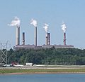
Duke Energy's Gibson Generating Station. Although it is the largest coal power plant in the US, GGS is often still referred to by locals as PSI, in reference to its original and long−time owner, Public Service Indiana.

See also
 In Spanish: Condado de Gibson (Indiana) para niños
