
Gillespie Field facts for kids
Quick facts for kids
Gillespie Field
|
|||||||||||||||||||
|---|---|---|---|---|---|---|---|---|---|---|---|---|---|---|---|---|---|---|---|

FAA airport diagram
|
|||||||||||||||||||
| Summary | |||||||||||||||||||
| Airport type | Public | ||||||||||||||||||
| Owner | County of San Diego | ||||||||||||||||||
| Serves | San Diego, California | ||||||||||||||||||
| Location | El Cajon, California | ||||||||||||||||||
| Elevation AMSL | 388 ft / 118 m | ||||||||||||||||||
| Coordinates | 32°49′34″N 116°58′21″W / 32.82611°N 116.97250°W | ||||||||||||||||||
| Website | co.san-diego.ca.us/dpw/... | ||||||||||||||||||
| Map | |||||||||||||||||||

SEE
Location in California

SEE
Location in the United States
|
|||||||||||||||||||
| Runway | |||||||||||||||||||
|
|||||||||||||||||||
| Statistics (2016) | |||||||||||||||||||
|
|||||||||||||||||||
|
Source: Federal Aviation Administration
|
|||||||||||||||||||
Gillespie Field (IATA: SEE, ICAO: KSEE, FAA LID: SEE) is a county-owned public towered airport 11.5 miles (10.0 nmi; 18.5 km) northeast of downtown San Diego, in El Cajon, San Diego County, California, United States.
Contents
History
- Section reference dates.
In 1942 the United States Marine Corps chose a site with 688 acres (278 ha) east of San Diego for parachute training for the newly forming Parachute battalions. In September 1942 Camp Gillespie was completed and named in honor of Lieutenant Archibald H. Gillespie, a Marine officer who played a prominent role in the effort to separate California from Mexico in the 1840s. Three 256 foot high towers were built from which the paratroopers practiced their jumps.
In February 1944, the camp was commissioned as Marine Corps Auxiliary Airfield Gillespie under the command of Marine Corps Air Station El Toro. MCAAF Gillespie soon became responsible for Camp Pendleton Outlying Air Field. Among the units that transited and trained at MCCAF Gillespie were VMSB-141, Air Warning Squadron 10 and the Navy's TBM-3 Avenger torpedo squadron VT-37.

In 1946 the airfield was turned over to San Diego County and became a general aviation facility.
In 1952 the County was granted ownership of the facility by the federal government.
In 1955, the County granted a 50-year lease for 180 acres (73 ha) of land adjacent, to the south, of the airport, which became the Cajon Speedway by 1961. The last race was run in 2004, and the County started expansion of the airport onto 70 acres (28 ha) of this land in 2005.
In 1971 the County Sheriff stationed ASTREA, a helicopter law enforcement base at the airport, and in 1993 the San Diego Aerospace Museum located its restoration operations and an exhibit at the field.
Facilities and operations
Gillespie Field covers 758 acres (307 ha) and has three asphalt runways:
- Runway 9L/27R: 5,342 ft × 100 ft (1,628 m × 30 m)
- Runway 9R/27L: 2,738 ft × 60 ft (835 m × 18 m)
- Runway 17/35: 4,145 ft × 100 ft (1,263 m × 30 m)
For the 12-month period ending December 31, 2016 the airport had 226,887 aircraft operations, average 622 per day: 99.8% general aviation, <1% air taxi and <1% military. At that time there were 547 aircraft are based at the airport: 86% single-engine, 7% multi-engine, 3% helicopter, 3% jet and 1% glider.
San Diego Air & Space Museum Gillespie Field Annex

Gillespie is the home of the restoration facility Gillespie Field Annex for the San Diego Air and Space Museum (formerly San Diego Aerospace Museum). It is open to the public and has on display many vintage and modern aircraft. It has an Atlas ICBM rocket as its gate guard, a recently restored F-102A Delta Dagger with drop tanks and AIM-4A Falcon missiles, and a Grumman F-14A Tomcat used in the Top Gun movie sequel. 32°49′42″N 116°57′58″W / 32.828421°N 116.966146°W
Images for kids
-
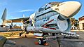
A-7B 154554 Corsair at SDASM Annex

See also
 In Spanish: Gillespie Field para niños
