
Gilmer County, Georgia facts for kids
Quick facts for kids
Gilmer County
|
|
|---|---|

Gilmer County courthouse in Ellijay
|
|

Location within the U.S. state of Georgia
|
|
 Georgia's location within the U.S. |
|
| Country | |
| State | |
| Founded | 1832 |
| Named for | George Rockingham Gilmer |
| Seat | Ellijay |
| Largest city | Ellijay |
| Area | |
| • Total | 431 sq mi (1,120 km2) |
| • Land | 427 sq mi (1,110 km2) |
| • Water | 4.7 sq mi (12 km2) 1.1%% |
| Population | |
| • Estimate
(2018)
|
30,816 |
| • Density | 66/sq mi (25/km2) |
| Time zone | UTC−5 (Eastern) |
| • Summer (DST) | UTC−4 (EDT) |
| Congressional district | 9th |
Gilmer County is a county located in the north central portion of the U.S. state of Georgia. As of the 2010 census, the population was 28,292. The county seat is Ellijay. It was based on a historic Cherokee town also spelled as Elejoy in the eighteenth century. The county was created on December 3, 1832 and was named for George Rockingham Gilmer, a politician who served two non-consecutive terms as governor of the state. Gilmer County is home of the annual Apple Festival, which is held in mid-October. Ninety percent of the land is in cropland and forest. Poultry raising and processing makes up the largest portion of the agricultural economy, which generates 33.2% of the total revenues. Manufacturing is about 20%.
Contents
History
During the Civil War, many men of Gilmer County enlisted in the Confederate Army. They served in the following units as well as the local home guard. Men from Gilmer would also join units in neighboring counties.
- 1st Georgia State Line, Company H, "Gilmer Browns"
- 11th Regiment, Georgia Infantry, Company D, Gilmer Boys
- 11th Regiment, Georgia Infantry, Company F, Mrs. Joe Brown's Boys
- 23rd Regiment, Georgia Infantry, Company D
- 39th Regiment, Georgia Infantry, Company G, Gilmer Lions
- 39th Regiment, Georgia Infantry, Company I, Gilmer Tigers 2
- 60th Regiment, Georgia Infantry, Company F, Gilmer Volunteers
- 65th Regiment, Georgia Infantry, Company (Smith's Legion) A, Gilmer Light Guards
- Gilmer 65th Regiment, Georgia Infantry, Company (Smith's Legion) H
The youngest enlisted soldier to serve in the Confederate Army was David Bailey Freeman from Ellijay. He enlisted in Company D 6th Georgia Cavalry with his brother on May 16, 1862 just two weeks before his 11th birthday. He was known as Little Dave and fought not as a musician or messenger but as an actual soldier. He fought at Chickamauga and during the Atlanta Campaign among other places.
Gilmer County was in no way left out of the war. The rough terrain of the North Georgia mountains made a "hideout" for Pro-Union men, Confederate deserters, and men avoiding being conscripted into military service. The state of Georgia fought back against these men by organizing Confederate Home Guard Units.
In 1864 there was an attempt to organize a pro union guerrilla force made up of these men in the mountains, called the 1st Georgia Infantry (US). They were equipped with weapons and supplies. They also stole horses and mules from Pro-Confederate families just as the Home Guard stole from the Pro-Union families. As a condition of their enlistment these men had only agreed to serve in Georgia. As a result, the unit was never recognized by the Federal Government.
On November 5, 1864 the 1st Georgia Infantry (US) went on a raid into Gilmer County near Bucktown to steal horses and mules. Here they met the Confederate Home Guard and the Battle of Bucktown ensued. Twenty-one of the union guerrillas were captured and several others were wounded and killed. In possession of the captured was a list of names of local supporters. Several of the captured turned out to be Confederate deserters who were executed in Gainesville on November 7.
The war would leave deep scars on Gilmer County for years after the war.
Geography
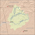
According to the U.S. Census Bureau, the county has a total area of 431 square miles (1,120 km2), of which 427 square miles (1,110 km2) is land and 4.7 square miles (12 km2) (1.1%) is water. The vast majority of Gilmer County is located in the Coosawattee River sub-basin in the ACT River Basin (Coosa-Tallapoosa River Basin). Three very small parts of the eastern and northern edges of the county are located in the Conasauga River sub-basin of the ACT River Basin, while slightly larger portions of the northern and eastern border areas of Gilmer County are located in the Ocoee River sub-basin of the Middle Tennessee-Hiwassee basin.
Adjacent counties
- Fannin County (north)
- Dawson County (southeast)
- Pickens County (south)
- Gordon County (southwest)
- Murray County (west)
National protected area
- Chattahoochee National Forest (part)
Transportation
Major highways
 U.S. Route 76
 State Route 2
 State Route 5
 State Route 52
 State Route 136
 State Route 282
 State Route 382
 State Route 515
Secondary highways
- Old S.R. 5
- Yukon Road
- Burnt Mountain Road (Old S.R. 108)
- Boardtown Road
- Big Creek Road
- Doublehead Gap Road
- Whitestone Road
- Conasauga Road
Demographics
| Historical population | |||
|---|---|---|---|
| Census | Pop. | %± | |
| 1840 | 2,536 | — | |
| 1850 | 8,440 | 232.8% | |
| 1860 | 6,724 | −20.3% | |
| 1870 | 6,644 | −1.2% | |
| 1880 | 8,386 | 26.2% | |
| 1890 | 9,074 | 8.2% | |
| 1900 | 10,198 | 12.4% | |
| 1910 | 9,237 | −9.4% | |
| 1920 | 8,406 | −9.0% | |
| 1930 | 7,344 | −12.6% | |
| 1940 | 9,001 | 22.6% | |
| 1950 | 9,963 | 10.7% | |
| 1960 | 8,922 | −10.4% | |
| 1970 | 8,956 | 0.4% | |
| 1980 | 11,110 | 24.1% | |
| 1990 | 13,368 | 20.3% | |
| 2000 | 23,456 | 75.5% | |
| 2010 | 28,292 | 20.6% | |
| 2018 (est.) | 30,816 | 8.9% | |
| U.S. Decennial Census 1790-1960 1900-1990 1990-2000 2010-2013 |
|||
2010 census
As of the 2010 United States Census, there were 28,292 people, 11,314 households, and 8,000 families living in the county. The population density was 66.3 inhabitants per square mile (25.6/km2). There were 16,564 housing units at an average density of 38.8 per square mile (15.0/km2). The racial makeup of the county was 92.3% white, 0.5% black or African American, 0.3% Asian, 0.3% American Indian, 0.1% Pacific islander, 5.2% from other races, and 1.3% from two or more races. Those of Hispanic or Latino origin, of any race, made up 9.5% of the population. In terms of ancestry, non-Hispanic people identified as 18.7% being Irish, 17.3% American, 16.3% of English ancestry, and 13.4% were German.
Of the 11,314 households, 29.2% had children under the age of 18 living with them, 57.2% were married couples living together, 8.9% had a female householder with no husband present, 29.3% were non-families, and 24.5% of all households were made up of individuals. The average household size was 2.48 and the average family size was 2.92. The median age was 43.4 years.
The median income for a household in the county was $36,741 and the median income for a family was $45,317. Males had a median income of $32,177 versus $27,288 for females. The per capita income for the county was $20,439. About 12.4% of families and 18.1% of the population were below the poverty line, including 24.1% of those under age 18 and 8.0% of those age 65 or over.
2020 census
| Race | Num. | Perc. |
|---|---|---|
| White | 26,365 | 84.09% |
| Black or African American | 127 | 0.41% |
| Native American | 62 | 0.2% |
| Asian | 131 | 0.42% |
| Other/Mixed | 1,069 | 3.41% |
| Hispanic or Latino | 3,599 | 11.48% |
As of the 2020 United States Census, there were 31,353 people, 12,021 households, and 8,028 families residing in the county.
Attractions
Gilmer County is home to an impressive specimen of yellow poplar known colloquially as "the big poplar". This particular specimen is 100 feet tall and approximately 20 feet in circumference at its base. The tree can be accessed via bear creek trail located in the Chattahoochee National Forest .
Communities
Cities
Census-designated place
Other unincorporated communities
- Cartecay
- Kiker (absorbed into Ellijay city limits)
- Tails Creek
- Whitepath
- Whitestone
- Yukon
Economy
Farming is still important, although, by 2002, the amount of land in the county devoted to agriculture had declined to 24.7 thousand acres. Most farms are sized at 10-49 acres, or 50-179 acres. Poultry raising and processing make up the largest portion of the agricultural economy. Agriculture and directly related businesses, such as landscape services, generate $565.1 million, or 33.2% of the county's economic output. Manufacturing generates $351.4 million, or 20.6%.
Images for kids
-

Blackberry Falls rapid on the Cartecay River near Ellijay
-
250 px

See also
 In Spanish: Condado de Gilmer (Georgia) para niños
