
Glassboro, New Jersey facts for kids
Quick facts for kids
Glassboro, New Jersey
|
||
|---|---|---|
|
Borough
|
||
| Borough of Glassboro | ||

Clockwise from top right: Glassblower Statue, Bunce Hall (Rowan University), glass bottles from area glassworks, Glassboro Municipal Building, Hollybush Mansion, panorama of the Rowan Boulevard downtown area, Glassboro Water Tower, and Historic West Jersey Depot (old train station).
|
||
|
||
| Nickname(s):
Summit City; Borough of Glass
|
||

Glassboro highlighted in Gloucester County. Inset map: Gloucester County highlighted in the State of New Jersey.
|
||

Census Bureau map of Glassboro, New Jersey
|
||

Glassboro, New Jersey
Location in Gloucester County, New Jersey

Glassboro, New Jersey
Location in New Jersey

Glassboro, New Jersey
Location in the United States
|
||
| Country | ||
| State | ||
| County | ||
| Established | 1779 | |
| Incorporated | March 11, 1878 | |
| Named for | Glass industry | |
| Government | ||
| • Type | Borough | |
| • Body | Borough Council | |
| Area | ||
| • Total | 9.36 sq mi (24.24 km2) | |
| • Land | 9.32 sq mi (24.14 km2) | |
| • Water | 0.04 sq mi (0.10 km2) 0.41% | |
| Area rank | 213th of 565 in state 14th of 24 in county |
|
| Elevation | 148 ft (45 m) | |
| Population | ||
| • Total | 18,579 | |
| • Estimate
(2019)
|
20,288 | |
| • Rank | 137th of 566 in state 5th of 24 in county |
|
| • Density | 2,022.9/sq mi (781.0/km2) | |
| • Density rank | 291st of 566 in state 10th of 24 in county |
|
| Time zone | UTC−05:00 (Eastern (EST)) | |
| • Summer (DST) | UTC−04:00 (Eastern (EDT)) | |
| ZIP Code |
08028
|
|
| Area code(s) | +1 (856) exchanges: 442, 863, 881, 256 (Rowan University) | |
| FIPS code | 3401526340 | |
| GNIS feature ID | 0885231 | |

Glassboro is a borough in Gloucester County, New Jersey, United States. As of the 2010 United States Census, the borough's population was 18,579, reflecting a decline of 489 (−2.6%) from the 19,068 counted in the 2000 Census, which had in turn increased by 3,454 (+22.1%) over the 15,614 counted in the 1990 Census.
What is now Glassboro was originally formed as a township by an act of the New Jersey Legislature on March 11, 1878, from portions of Clayton Township. Portions of the township were taken to form Elk Township (April 17, 1891) and Pitman (May 24, 1905). Glassboro was incorporated as a borough on March 18, 1920, replacing Glassboro Township. The borough was named for its glass industry.
Glassboro is home to Rowan University, founded in 1923 and formerly known as Glassboro State College, which was the site of the Glassboro Summit Conference in 1967 between U.S. President Lyndon B. Johnson and Soviet Premier Alexei Kosygin.
Contents
History
Glassboro's early history was built on the manufacturing of glass. The town was first established in 1779 by Solomon Stanger as "Glass Works in the Woods"; glass manufacturers over the years since include Heston-Carpenter Glass Works, Olive Glass Works, Harmony Glass Works, Temperanceville Glass Works, Whitney Brothers Glass Works, Owens Bottle Company, Owens Illinois Glass Company, and Anchor Hocking.
The Glassboro Summit Conference between U.S. President Lyndon B. Johnson and Soviet Premier Alexei Kosygin took place in Glassboro. Johnson and Kosygin met for three days from June 23 to June 25, 1967, at Glassboro State College (later renamed Rowan University). The location was chosen as a compromise. Kosygin, having agreed to address the United Nations in New York City, wanted to meet in New York. Johnson, wary of encountering protests against the Vietnam War, preferred to meet in Washington, D.C. They agreed on Glassboro because it was equidistant between the two cities. The generally amicable atmosphere of the summit was referred to as the "Spirit of Glassboro," although the leaders failed to reach agreement on limiting anti-ballistic missile systems.
On June 19, 1986, Ronald Reagan became the first sitting president to speak at a high school graduation when he spoke at the Glassboro High School commencement ceremonies.
Geography
According to the United States Census Bureau, the borough had a total area of 9.221 square miles (23.882 km2), including 9.184 square miles (23.787 km2) of land and 0.037 square miles (0.095 km2) of water (0.40%).
Unincorporated communities, localities and place names located partially or completely within the borough include Elsemere.
Glassboro borders Elk Township, Clayton Borough, Monroe Township, Washington Township, Pitman Borough, Mantua Township, and Harrison Township.
Climate
The climate in this area is characterized by hot, humid summers and generally mild to cool winters. According to the Köppen Climate Classification system, Glassboro has a humid subtropical climate, abbreviated "Cfa" on climate maps.
Demographics
| Historical population | |||
|---|---|---|---|
| Census | Pop. | %± | |
| 1880 | 2,088 | — | |
| 1890 | 2,642 | 26.5% | |
| 1900 | 2,677 | 1.3% | |
| 1910 | 2,821 | 5.4% | |
| 1920 | 3,073 | 8.9% | |
| 1930 | 4,799 | 56.2% | |
| 1940 | 4,925 | 2.6% | |
| 1950 | 5,867 | 19.1% | |
| 1960 | 10,253 | 74.8% | |
| 1970 | 12,938 | 26.2% | |
| 1980 | 14,574 | 12.6% | |
| 1990 | 15,614 | 7.1% | |
| 2000 | 19,068 | 22.1% | |
| 2010 | 18,579 | −2.6% | |
| 2019 (est.) | 20,288 | 9.2% | |
| Population sources: 1880–2000 1880–1920 1880–1890 1890–1910 1910–1930 1930–1990 2000 2010 * = Lost territory in previous decade. |
|||
Census 2010
As of the census of 2010, there were 18,579 people, 6,158 households, and 3,972 families residing in the borough. The population density was 2,022.9 per square mile (781.0/km2). There were 6,590 housing units at an average density of 717.5 per square mile (277.0/km2)*. The racial makeup of the borough was 72.25% (13,423) White, 18.67% (3,469) Black or African American, 0.11% (21) Native American, 2.87% (534) Asian, 0.05% (10) Pacific Islander, 3.12% (580) from other races, and 2.92% (542) from two or more races. [[Hispanic (U.S. Census)|Hispanic or Latino of any race were 7.42% (1,378) of the population.
There were 6,158 households out of which 28.1% had children under the age of 18 living with them, 44.4% were married couples living together, 16.0% had a female householder with no husband present, and 35.5% were non-families. 22.5% of all households were made up of individuals, and 7.8% had someone living alone who was 65 years of age or older. The average household size was 2.66 and the average family size was 3.13.
In the borough, the population was spread out with 19.4% under the age of 18, 26.4% from 18 to 24, 21.1% from 25 to 44, 22.4% from 45 to 64, and 10.7% who were 65 years of age or older. The median age was 28.4 years. For every 100 females there were 97.1 males. For every 100 females ages 18 and old there were 95.0 males.
The Census Bureau's 2006–2010 American Community Survey showed that (in 2010 inflation-adjusted dollars) median household income was $54,795 (with a margin of error of +/- $3,793) and the median family income was $67,171 (+/- $9,496). Males had a median income of $49,695 (+/- $4,361) versus $43,489 (+/- $2,608) for females. The per capita income for the borough was $23,108 (+/- $1,421). About 9.3% of families and 14.5% of the population were below the poverty line, including 18.6% of those under age 18 and 5.0% of those age 65 or over.
Census 2000
As of the 2000 United States Census there were 19,068 people, 6,225 households, and 4,046 families residing in the borough. The population density was 2,071.3 people per square mile (799.4/km2). There were 6,555 housing units at an average density of 712.0 per square mile (274.8/km2). The racial makeup of the borough was 74.5% White, 19.5% African American, 0.2% Native American, 2.3% Asian, 0.1% Pacific Islander, 1.5% from other races, and 2.0% from two or more races. Hispanic or Latino of any race were 3.8% of the population.
There were 6,225 households, out of which 32.5% had children under the age of 18 living with them, 46.3% were married couples living together, 14.6% had a female householder with no husband present, and 35.0% were non-families. 23.6% of all households were made up of individuals, and 8.4% had someone living alone who was 65 years of age or older. The average household size was 2.66 and the average family size was 3.17.
In the borough the population was spread out, with 22.1% under the age of 18, 25.6% from 18 to 24, 25.9% from 25 to 44, 16.6% from 45 to 64, and 9.8% who were 65 years of age or older. The median age was 27 years. For every 100 females, there were 91.8 males. For every 100 females age 18 and over, there were 89.3 males.
The median income for a household in the borough was $44,992, and the median income for a family was $55,246. Males had a median income of $40,139 versus $30,358 for females. The per capita income for the borough was $18,113. About 8.5% of families and 15.2% of the population were below the poverty line, including 15.6% of those under age 18 and 7.9% of those age 65 or over.
Transportation
_from_the_overpass_for_Gloucester_County_Route_641_(Ellis_Mill_Road)_in_Glassboro,_Gloucester_County,_New_Jersey.jpg)
Roads and highways
As of May 2010[update], the borough had a total of 78.43 miles (126.22 km) of roadways, of which 57.61 miles (92.71 km) were maintained by the municipality, 13.29 miles (21.39 km) by Gloucester County and 7.53 miles (12.12 km) by the New Jersey Department of Transportation.
Glassboro is crisscrossed by a number of major roads. County Route 553, Route 47 and Route 55 (limited access) travel north–south, while U.S. Route 322 (much of which is also Mullica Hill Road) passes through east–west.
Public transportation
NJ Transit provides bus service to and from Philadelphia on the 313, 408 and 412 routes.
The Pureland East-West Community Shuttle connects the Pureland Industrial Complex and the Avandale Park and Ride.
Passenger train service to Glassboro existed from 1860 to 1971. The Glassboro station used by the Pennsylvania-Reading Seashore Lines is being renovated as a visitor center. A new station at Rowan University in the vicinity of the historic depot is the planned for the proposed Glassboro–Camden Line, an 18-mile (28.97 km) diesel multiple unit (DMU) light rail system. The terminal station would be one stop further at Main and High streets.
Walking and cycling
Walking is a popular form of transportation especially around the university where many underclassmen are not permitted to have cars.
The Glassboro - Williamstown Trail (also known as the Monroe Township Bikepath) runs for more than 6 miles (9.7 km) between Glassboro and the Williamstown section of Monroe Township. The trail traverses the Glassboro State Wildlife Refuge before terminating at Delsea Drive. Future work will extend this trail along former railroad right of way from Delsea Drive to Rowan U's Bunce Hall. Path links to Elmer and Pitman are also proposed.
Education

The Glassboro Public Schools serve students in pre-kindergarten through twelfth grade. As of the 2017–18 school year, the district, comprised of five schools, had an enrollment of 2,088 students and 179.2 classroom teachers (on an FTE basis), for a student–teacher ratio of 11.7:1. Schools in the district (with 2017–18 enrollment data from the National Center for Education Statistics) are J. Harvey Rodgers School 291 students in grades PreK and kindergarten, Dorothy L. Bullock School 462 students in grades 1–3, Thomas E. Bowe Elementary School 463 students in grades 4–6, Glassboro Intermediate School 287 students in grades 7-8 and Glassboro High School 533 students in grades 9-12.
Students from across the county are eligible to apply to attend Gloucester County Institute of Technology, a four-year high school in Deptford Township that provides technical and vocational education. As a public school, students do not pay tuition to attend the school.
The Roman Catholic Diocese of Camden operates St. Michael the Archangel School in Clayton; the former St. Bridget Regional School in Glassboro merged into St. Michael in 2008.
Rowan University is a public university with an enrollment of 19,500 undergraduate and graduate students in 2018–19. The university was founded in 1923 as Glassboro Normal School on a 25-acre (10 ha) site donated by the borough. The school became New Jersey State Teachers College at Glassboro in 1937 and Glassboro State College in 1958. Starting in the 1970s, it expanded into a multi-purpose institution, adding programs in business, communications, and engineering. Rowan Boulevard is a mixed-use development intended to provide a vibrant downtown district for Glassboro, incorporating university student life into its design, as part of an effort to accommodate a student body that is projected to grow to about 25,000 in 2023.
Notable people
People who were born in, residents of, or otherwise closely associated with Glassboro include:
- John Aveni (1935–2002), kicker for the Chicago Bears.
- Gary Brackett (born 1980), linebacker on the Super Bowl XLI champion Indianapolis Colts.
- Mark Lambert Bristol (1868–1939), rear admiral in the United States Navy.
- King Kong Bundy (1957-2019) American professional wrestler, stand-up comedian and actor.
- Mary Carnell (1861-1925), photographer
- Betty Castor (born 1941), Florida Senate Candidate and former President of The University of South Florida.
- Corey Clement (born 1994), running back for the Super Bowl LII champion Philadelphia Eagles.
- Joe Crispin (born 1979), former NBA player for the Phoenix Suns and Los Angeles Lakers.
- Daniel Dalton (born 1949), politician who served as New Jersey Senate Majority Leader and as Secretary of State of New Jersey.
- Sean F. Dalton (born 1962), Prosecutor of Gloucester County, New Jersey who previously served two terms in the New Jersey General Assembly, where he represented the 4th Legislative District.
- Thomas M. Ferrell (1844–1916) represented New Jersey's 1st congressional district in the United States House of Representatives from 1883 to 1885.
- Cathe Friedrich (born 1964), athlete, instructor and innovator in the fitness video industry.
- Kerry Getz (born 1975), professional skateboarder.
- Jaden (born 1977), professional wrestling manager and commentator.
- George Johnson (born 1987), defensive end for the Detroit Lions of the National Football League.
- Juwan Johnson (born 1996), American football wide receiver for the New Orleans Saints of the National Football League.
- Jarvis Lynch (born 1933), retired major general in the United States Marine Corps.
- Oscar Moore (born 1938), long-distance runner who competed in the men's 5000 metres at the 1964 Summer Olympics.
- Thomas J. Osler (born c. 1940), mathematician, former national champion distance runner and author.
- Brian Oliver (born 1990), professional basketball player.
Images for kids
-
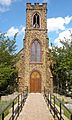
St. Thomas Episcopal Church, built in 1846, is one of the oldest buildings in the borough.

See also
 In Spanish: Glassboro para niños
