
Gloucester, Massachusetts facts for kids
Quick facts for kids
Gloucester, Massachusetts
|
||
|---|---|---|

Man at the Wheel, Fisherman's Memorial Cenotaph
|
||
|
||
| Nickname(s):
"The Place To Be In The Summer"
|
||
| Motto(s):
"America's Oldest Seaport"
|
||

Location in Essex County and the state of Massachusetts.
|
||

Gloucester, Massachusetts
Location in Massachusetts

Gloucester, Massachusetts
Location in the United States
|
||
| Country | ||
| State | ||
| County | Essex | |
| Settled | 1623 | |
| Incorporated (town) | 1642 | |
| Incorporated (city) | 1873 | |
| Government | ||
| • Type | Mayor-council city | |
| Area | ||
| • Total | 41.51 sq mi (107.51 km2) | |
| • Land | 26.20 sq mi (67.85 km2) | |
| • Water | 15.31 sq mi (39.66 km2) | |
| Elevation | 50 ft (15 m) | |
| Population
(2020)
|
||
| • Total | 29,729 | |
| • Density | 1,134.69/sq mi (438.16/km2) | |
| Time zone | UTC−5 (Eastern) | |
| • Summer (DST) | UTC−4 (Eastern) | |
| ZIP code |
01930
|
|
| Area code(s) | 351 / 978 | |
| FIPS code | 25-26150 | |
| GNIS feature ID | 0615084 | |

Gloucester is a city in Essex County, Massachusetts, in the United States. It sits on Cape Ann and is part of Massachusetts's North Shore. The population was 29,729 at the 2020 U.S. Census. An important center of the fishing industry and a popular summer destination, Gloucester consists of an urban core on the north side of the harbor and the outlying neighborhoods of Annisquam, Bay View, Lanesville, Folly Cove, Magnolia, Riverdale, East Gloucester, and West Gloucester.
Contents
History
The boundaries of Gloucester originally included the town of Rockport, in an area dubbed "Sandy Bay". That village separated formally on February 27, 1840. In 1873, Gloucester was reincorporated as a city.
Early Gloucester
Gloucester was founded at Cape Ann by an expedition called the "Dorchester Company" of men from Dorchester (in the county of Dorset, England) chartered by James I in 1623. It was one of the first English settlements in what would become the Massachusetts Bay Colony, and predates both Salem in 1626 and Boston in 1630. The first company of pioneers made landing at Half Moon Beach and settled nearby, setting up fishing stages in a field in what is now Stage Fort Park. This settlement's existence is proclaimed today by a memorial tablet, affixed to a 50-foot (15 m) boulder in that park.
Life in this first settlement was harsh and it was short-lived. Around 1626 the place was abandoned, and the people removed themselves to Naumkeag (what is now called Salem, Massachusetts), where more fertile soil for planting was to be found. The meetinghouse was even disassembled and relocated to the new place of settlement. At some point in the following years – though no record exists – the area was slowly resettled. The town was formally incorporated in 1642. It is at this time that the name "Gloucester" first appears on tax rolls, although in various spellings. The town took its name from the city of Gloucester in South-West England, perhaps from where many of its new occupants originated but more likely because Gloucester, England, was a Parliamentarian stronghold, successfully defended with the aid of the Earl of Essex against the King in the Siege of Gloucester of 1643.
This new permanent settlement focused on the Town Green area, an inlet in the marshes at a bend in the Annisquam River. This area is now the site of Grant Circle, a large traffic rotary at which Massachusetts Route 128 mingles with a major city street (Washington Street/Rt 127). Here the first permanent settlers built a meeting house and therefore focused the nexus of their settlement on the "Island" for nearly 100 years. Unlike other early coastal towns in New England, development in Gloucester was not focused around the harbor as it is today, rather it was inland that people settled first. This is evidenced by the placement of the Town Green nearly two miles from the harbor-front.
The Town Green is also where the settlers built the first school. By Massachusetts Bay Colony Law, any town boasting 100 families or more had to provide a public schoolhouse. This requirement was met in 1698, with Thomas Riggs standing as the town's first schoolmaster.
The White-Ellery House was erected in 1710 upon the Town Green. It was built at the edge of a marsh for Gloucester’s first settled minister, the Reverend John White (1677–1760).
Early industry included subsistence farming and logging. Because of the poor soil and rocky hills, Cape Ann was not well suited for farming on a large scale. Small family farms and livestock provided the bulk of the sustenance to the population. Fishing, for which the town is known today, was limited to close-to-shore, with families subsisting on small catches as opposed to the great bounties yielded in later years. The fisherman of Gloucester did not command the Grand Banks until the mid-18th century. Historian Christine Heyrman, examining the town's society between 1690 and 1750, finds that at the beginning community sensibility was weak in a town that was a loose agglomeration of individuals. Commerce and capitalism transformed the society, making it much more closely knit with extended families interlocking in business relationships.
Early Gloucestermen cleared great swaths of the forest of Cape Ann for farm and pasture land, using the timber to build structures as far away as Boston. The rocky moors of Gloucester remained clear for two centuries until the forest reclaimed the land in the 20th century. The inland part of the island became known as the "Commons", the "Common Village", or "Dogtown". Here small dwellings lay scattered amongst the boulders and swamps, along roads that meandered through the hills. These dwellings were at times little more than shanties; only one was even two stories tall. Despite their size, several generations of families were raised in such houses. One feature of the construction of these houses was that under one side of the floor was dug a cellar hole (for the keeping of food), supported by a foundation of laid-stone (without mortar). These cellar holes are still visible today along the trails throughout the inland part of Gloucester; they, and some walls, are all that remain of the village there.

Growth
_map.jpg)
The town grew, and eventually colonists lived on the opposite side of the Annisquam River. This, in a time of legally mandated church attendance, was a long way to walk – or row – on a Sunday morning. In 1718 the settlers on the opposite shore of the river split off from the First Parish community at the Green and formed "Second Parish". While still part of the town of Gloucester, the people of Second, or "West", Parish now constructed their own meetinghouse and designated their own place of burial, both of which were in the hills near the marshes behind Wingaersheek Beach. The meetinghouse is gone now, but deep in the woods on the Second Parish Road, Old Thompson road, one can still find the stone foundation and memorial alter, as well as scattered stones of the abandoned burial ground.
Other parts of town later followed suit. Third Parish, in northern Gloucester, was founded in 1728. Fourth Parish split off from First Parish in 1742. Finally, in 1754, the people of Sandy Bay (what would later be called Rockport) split off from First Parish to found Fifth Parish. The Sandy Bay church founding was the last religious re-ordering of the colonial period. All of these congregations still exist in some form, with the exception of Fourth Parish, the site of whose meeting house is now a highway.
At one time, there was a thriving granite industry in Gloucester.
Geography and transportation

Gloucester is located at 42°37′26″N 70°40′32″W / 42.62389°N 70.67556°W (42.624015, −70.675521). According to the United States Census Bureau, the city has a total area of 41.5 square miles (107.5 km2), of which 26.2 square miles (67.8 km2) is land and 15.3 square miles (39.6 km2), or 36.88%, is water.
Gloucester occupies most of the eastern end of Cape Ann, except for the far tip, which is the town of Rockport. The city is split in half by the Annisquam River, which flows northward through the middle of the city into Ipswich Bay. At its south end it is connected to Gloucester Harbor by the Blynman Canal. The land along the northwestern shore of the river is marshy, creating several small islands. Gloucester Harbor is divided into several smaller coves, including the Western Harbor (site of the Fisherman's Memorial) and the Inner Harbor (home to the Gloucester fishing fleet). The eastern side of Gloucester Harbor is divided from the rest of Massachusetts Bay by Eastern Point, extending some 2 miles (3 km) outward from the mainland. There are several parks in the city, the largest of which are Ravenswood Park, Stage Fort Park and Mount Ann Park.
Gloucester lies between Ipswich Bay to the north and Massachusetts Bay to the south. The city is bordered on the east by Rockport, and on the west by Ipswich, Essex and Manchester-by-the-Sea to the west. (The town line with Ipswich is located across Essex Harbor, and as such there is no land connection between the towns.) Gloucester lies 16 miles (26 km) east-northeast of Salem and 31 miles (50 km) northeast of Boston. Gloucester lies at the eastern terminus of Route 128, which ends at Route 127A. Route 127A begins at Route 127 just east of the Route 128 terminus, heading into Rockport before terminating there. Route 127 enters from Manchester-by-the-Sea before crossing the Blynman Canal and passing through downtown towards Rockport. It then re-enters Gloucester near Folly Cove, running opposite of its usual north–south orientation towards its terminus at Route 128. Route 133 also terminates within the city, entering from Essex and terminating just west of the Blynman Canal at Route 127. Besides the bridge over the Blynman Canal, there are only two other connections between the eastern and western halves of town, the A. Piatt Andrew Memorial Bridge, carrying Route 128, and the Boston & Maine Railroad Bridge, just north of the Blynman Canal.
Gloucester is home to the Cape Ann Transportation Authority, which serves the city and surrounding towns. Two stops, in West Gloucester and in downtown Gloucester, provide access to the Newburyport/Rockport Line of the MBTA Commuter Rail, which extends from Rockport along the North Shore to Boston's North Station. The nearest airport is the Beverly Municipal Airport, with the nearest national and international air service being at Boston's Logan International Airport.
Demographics
| Historical population | ||
|---|---|---|
| Year | Pop. | ±% |
| 1790 | 5,317 | — |
| 1800 | 5,313 | −0.1% |
| 1810 | 5,943 | +11.9% |
| 1820 | 6,384 | +7.4% |
| 1830 | 7,510 | +17.6% |
| 1840 | 6,350 | −15.4% |
| 1850 | 7,786 | +22.6% |
| 1860 | 10,904 | +40.0% |
| 1870 | 15,389 | +41.1% |
| 1880 | 19,329 | +25.6% |
| 1890 | 24,651 | +27.5% |
| 1900 | 26,121 | +6.0% |
| 1910 | 24,398 | −6.6% |
| 1920 | 22,947 | −5.9% |
| 1930 | 24,204 | +5.5% |
| 1940 | 24,046 | −0.7% |
| 1950 | 25,167 | +4.7% |
| 1960 | 25,789 | +2.5% |
| 1970 | 27,941 | +8.3% |
| 1980 | 27,768 | −0.6% |
| 1990 | 28,716 | +3.4% |
| 2000 | 30,273 | +5.4% |
| 2010 | 28,789 | −4.9% |
| 2020 | 29,729 | +3.3% |
| * = population estimate. Source: United States Census records and Population Estimates Program data. Source: |
||

As of the 2000 census, there were 30,273 people, 12,592 households, and 7,895 families residing in the city. The population density was 1,166.0 people per square mile (450.2/km2). There were 13,958 housing units at an average density of 537.6 per square mile (207.6/km2). The racial makeup of the city was 91.99% White, 6.61% African American, 0.72% Asian, 0.12% Native American, 0.02% Pacific Islander, 0.50% from other races, and 1.03% from two or more races. Hispanic or Latino of any race were 15.48% of the population. 22.6% were of Italian, 16.2% Irish, 11.1% English, 8.5% Portuguese and 7.1% American ancestry according to Census 2000.
There were 12,592 households, out of which 27.6% had children under the age of 18 living with them, 48.8% were married couples living together, 10.6% had a female householder with no husband present, and 37.3% were non-families. 30.7% of all households were made up of individuals, and 11.4% had someone living alone who was 65 years of age or older. The average household size was 2.38 and the average family size was 3.00.

In the city, the population was spread out, with 22.0% under the age of 18, 6.5% from 18 to 24, 29.9% from 25 to 44, 26.1% from 45 to 64, and 15.6% who were 65 years of age or older. The median age was 40 years. For every 100 females, there were 92.0 males. For every 100 females age 18 and over, there were 88.8 males.
The median income for a household in the city was $58,568, and the median income for a family was $80,970 from a 2007 estimate. Males had a median income of $41,465 versus $30,566 for females. The per capita income for the city was $25,595. About 7.1% of families and 8.8% of the population were below the poverty line, including 11.8% of those under age 18 and 11.2% of those age 65 or over.
Gloucester and the sea

The town was an important shipbuilding center, and the first schooner was reputedly built there in 1713. The community developed into an important fishing port, largely due to its proximity to Georges Bank and other fishing banks off the east coast of Nova Scotia and Newfoundland. Gloucester's most famous (and nationally recognized) seafood business was founded in 1849 as John Pew & Sons. It became Gorton-Pew Fisheries in 1906, and in 1957 changed its name to Gorton's of Gloucester. The iconic image of the "Gorton's Fisherman", and the products he represents, are known throughout the country and beyond. Besides catching and processing seafood, Gloucester is also a center for research on marine life and conservation ; Ocean Alliance is headquartered in the city.
In the late 19th century Gloucester saw an influx of Portuguese and Italian immigrants seeking work in the town's flourishing fishing industry and a better life in America. Some present-day fishermen of Gloucester are descendents of these early immigrants. The strong Portuguese and Italian influence is evident in the many festivals celebrated throughout the year. During the Catholic celebration, St Peter's Fiesta, relatives of fishermen past and present carry oars representing many of the fishing vessels which call Gloucester their home. Saint Peter is the patron saint of the fishermen.
Seafaring and fishing have been, and still are, very dangerous undertakings. In its over 350-year history, Gloucester has lost over 10,000 men to the Atlantic Ocean. The names of each of the known lost are painted on a huge mural in the main staircase at City Hall, and also on a new memorial cenotaph on Stacy Boulevard. The list has continued to lengthen despite increased safety requirements.
Arts
Painting and printmaking


Gloucester's scenic beauty, active fishing industry, and renowned arts community have attracted and inspired painters since the early 19th century, as they do today. The first Gloucester painter of note was native-born Fitz Henry Lane, whose home still exists on the waterfront. The premier collection of his works is in the Cape Ann Museum, which holds 40 of his paintings and 100 of his drawings. Other painters subsequently attracted to Gloucester include, William Morris Hunt, Winslow Homer, Childe Hassam, John Twachtman, Frederick Mulhaupt, Frank Duveneck, Cecilia Beaux, Jane Peterson, Gordon Grant, Harry DeMaine, Emile Gruppe, Stuart Davis, Joseph Solman, Mark Rothko, Milton Avery, Barnett Newman, William Meyerowitz, Joan Lockhart, Theresa Bernstein, and Marsden Hartley, and artists from the Ashcan School such as Edward Hopper, John Sloan, Robert Henri, William Glackens, and Maurice Prendergast.

Smith Cove is home to the Rocky Neck Art Colony, the oldest art colony in the country. Folly Cove was the home of the Folly Cove Designers, influential to this day in print design and technique.
Sculpture
Several important sculptors have lived and worked in East Gloucester, Annisquam, Lanesville and Folly Cove. They include George Aarons, Anna Hyatt Huntington, Charles Grafly, Paul Manship and his daughter-in-law Margaret Cassidy Manship, Walker Hancock, and George Demetrios. In addition, Aristides Demetrios grew up in Folly Cove.
Literature
- Captains Courageous (1897) by Rudyard Kipling was set in Gloucester, and adapted as a 1937 movie starring Spencer Tracy.
- Charles Olson (1910–1970), a poet and teacher at Black Mountain College in North Carolina, composed a 635-page poem known as The Maximus Poems, which centered on Gloucester.
- Gloucester is often referred to in the works of horror writer H. P. Lovecraft. The fictional town of Innsmouth in Lovecraft's The Shadow Over Innsmouth is believed partially based on Cape Ann as a whole and Gloucester in particular.
- The book, The Perfect Storm, which recounted a massive storm of 1991, had figures based in the town. Scenes from the film adaptation by the same name were filmed there.
- Gloucester and its coast guard station are the center of the land action in Michael J. Tougias' 2005 book Ten Hours Until Dawn, recounting the loss of the pilot boat Can Do and its crew during the blizzard of 1978.
Comics
Gloucester is the birthplace of Marvel character Dane Whitman whose superhero alter ego is the Black Knight.
Points of interest

- The schooner Adventure
- Annisquam
- Cape Ann Museum
- Dogtown Common
- Norman's Woe, known for several shipwrecks, including The Wreck of the Hesperus
- Ravenswood Park
- Rocky Neck Art Colony, America's oldest working art colony
- Sargent House Museum
- White-Ellery House
Gloucester's most noted landmark is the harborside Man at the Wheel statue (also known as the "Gloucester Fisherman's Memorial Cenotaph"), dedicated to "They that go down to the sea in ships", which is a quote from Psalm 107:23–32.
Gloucester has a professional theatre company known as the Gloucester Stage Company, which stages five to eight plays each season, primarily in the summer months. Located in East Gloucester, the theatre sits at water's edge overlooking Smith's Cove. It was founded in 1979 by local arts and business leaders to encourage playwrights and their new works. Israel Horovitz, who founded the GSC, was also its artistic director from 1979 to 2006. Over the years, plays developed at the Gloucester Stage Company have gone on to critical acclaim and popular success, on and off Broadway, nationally and internationally. The group draws theatre-goers from Gloucester, neighboring North Shore districts, and the greater Boston area, as well as seasonal residents and tourists.
Gloucester's largest annual event is St. Peter's Fiesta, sponsored by the local Italian-American community. It is held the last weekend in June, which is typically the weekend closest to the saint's feast day. Preceded by a nine-day novena of prayers, the festival highlights include the blessing of the fleet and the greasy pole contest.
The city has much significant architecture, from pre-Revolutionary houses to the hilltop 1870 City Hall, which dominates the town and harbor. It also has exotic waterfront homes now converted to museums, including Beauport, built 1907–1934 by designer Henry Davis Sleeper in collaboration with local architect Halfdan Hanson, said to raise eclecticism to the level of genius. In addition, it has Hammond Castle, built 1926–1929 by inventor John Hays Hammond, Jr., as a setting for his collection of Roman, medieval and Renaissance artifacts. Gloucester was also the home of feminist writer Judith Sargent Murray and John Murray, the founder of the first Universalist Church in America. Their house still exists as the Sargent House Museum. Many museums are located in the main downtown area, such as the Cape Ann Museum, and the museum/aquarium Maritime Gloucester.
Economy
Gorton's of Gloucester, Mighty Mac, Gloucester Engineering, Good Harbor Consulting, Para Research, Aid-Pack, Cyrk, and Varian Semiconductor are among the companies based in Gloucester.
Education
The following schools are located within the Gloucester Public Schools District:
- Gloucester High School (9–12)
- O'Maley Innovation Middle School (6–8)
- East Gloucester Elementary School (K–5)
- Plum Cove Elementary School (K–5)
- Beeman Elementary School (K–5)
- Veteran's Memorial School (K–5)
- West Parish Elementary School (K–5) (site of the West Parish Elementary School Science Park)
- Gloucester Preschool
Notable people
- Sylvester Ahola, jazz trumpeter and cornetist
- Willie Alexander, singer and keyboard player, formerly of the Lost, the Bagatelle, the Grass Menagerie and the Boom Boom Band, before briefly becoming a member of The Velvet Underground, was raised and is based in Gloucester; much of his later work involves collaborations in various media with area's rich arts community
- A. Piatt Andrew, congressman, Assistant Treasury Secretary, and Harvard professor; Route 128 bridge connecting the island and mainland portions of Gloucester was named after him
- Roger Babson, founder of Babson College and presidential candidate for Prohibition Party in 1940
- Walworth Barbour, diplomat, lived for many years in Gloucester
- Thomas P. Barnett, painter
- Jonathan Bayliss, novelist and playwright
- Cecilia Beaux, painter and society portraitist
- Howard Blackburn, fisherman and adventurer
- Nell Blaine, painter
- Clarence Birdseye, founder of modern frozen food industry
- Kyle Bochniak, MMA Fighter
- Phil Bolger, prolific 20th-century boat designer with 668 designs to his credit, designed Canadian-built tall ship HMS Rose later renamed HMS Surprise for use in Master and Commander: The Far Side of the World
- Hugo Burnham, drummer and founding member of British post-punk band Gang of Four
- Virginia Lee Burton (1909–1968), children's book author and illustrator (The Little House and Mike Mulligan and His Steam Shovel), founder of the Folly Cove Designers group
- Roger Conant, first governor of the Cape Ann colony, moved the colony's center from the Gloucester area to Salem
- Carleton S. Coon, physical anthropologist and president of the American Association of Physical Anthropologists
- Roger Cressey, former member of United States National Security Council, terrorism analyst for NBC News, president of Good Harbor Consulting, and adjunct professor at Georgetown University
- Thomas Dalton, abolitionist leader
- Aristides Demetrios, sculptor, grew up in Gloucester as son of Virginia Lee Burton
- James Elliot, author and United States Representative from Vermont
- Henry Ferrini, critically acclaimed independent filmmaker, nephew of Vincent Ferrini
- Vincent Ferrini, poet, first Poet Laureate of Gloucester
- Thomas Gardner, landed in 1624 at Cape Ann to form colony at what is now known as Gloucester
- Gregory Gibson, author of Goneboy: a Walkabout, Demon of the Waters and Hubert's Freaks
- Raymond Greenleaf, actor
- Emil Gruppe, painter
- John Hays Hammond, Jr., inventor known as "The Father of Radio Control", built Hammond Castle as his home and laboratory
- Halfdan M. Hanson, architect, most noted for collaboration with Henry Davis Sleeper on Beauport, Sleeper-McCann House
- Walker Hancock, sculptor
- Sterling Hayden, actor and writer
- Helen Hayes, actor, spent her summers in Annisquam
- Winslow Homer, landscape painter and printmaker, lived and painted in Gloucester in 1870s
- Israel Horovitz, playwright and father of Adam Horovitz of Beastie Boys
- Alpheus Hyatt, naturalist and paleontologist
- Anna Hyatt Huntington, animalier sculptor and daughter of Alpheus Hyatt
- Elliott Jaques, psychoanalyst, social scientist, known for coining term "mid-life crisis"; moved to Gloucester in 1991 and lived there till death in 2003
- Alfred "Centennial" Johnson, first recorded single-handed crossing of Atlantic Ocean
- Hilton Kramer, art critic and essayist, was born in, and grew up in, Gloucester
- Fitz Henry Lane, Luminist painter, born and lived in Gloucester
- Paul Manship, sculptor
- Stuffy McInnis, Major League Baseball player and manager, Harvard baseball coach
- Tony Millionaire, artist and animator best known for comic strip Maakies and Cartoon Network's Drinky Crow Show
- Shawn Milne, Cyclist
- William Monahan, Academy Award-winning screenwriter
- Sun Myung Moon, leader of the Unification Church, spent a great deal of time in Gloucester, and the Unification Church at one time owned a large amount of waterfront property
- Richard Murphy, schooner captain
- John Murray, founder of Universalist denomination in the United States
- Judith Sargent Murray, feminist, essayist, playwright, and poet
- Laura Nyro, singer and songwriter, lived in Gloucester for a number of years
- Charles Olson, Black Mountain College poet
- Kris Osborn, former CNN commentator and current columnist for various military industry blogs
- Mark Parisi, author of syndicated comic strip Off the Mark, was born in Gloucester
- Cy Perkins, Major League Baseball catcher
- Herb Pomeroy, jazz musician, born in Gloucester
- Jessie Ralph, actress
- Marc Randazza, First Amendment lawyer, legal news commentator, columnist (Fox News and CNN)
- Russ Russo, actor
- Daniel Sargent, merchant, politician
- Epes Sargent, editor, poet and playwright
- Henry Sargent, painter and military man
- Paul Dudley Sargent, Revolutionary War hero, one of founding overseers of Bowdoin College
- Winthrop Sargent, patriot, governor, politician, writer; member of Federalist party
- Ben Smith, Olympic ice hockey coach, son of Benjamin A. Smith II, born in Gloucester
- Benjamin A. Smith II, U.S. senator from Massachusetts (1960–1962), Mayor of Gloucester (1954–1955)
- William Stacy (1734–1802), Revolutionary War officer, pioneer to Ohio Country
- Vermin Supreme, performance artist, anarchist, politician, and activist (perennial presidential candidate)
- Martin Welch, schooner captain, winner of first International Fishing Schooner Championship Races
- Philip Saltonstall Weld, famed sailor and newspaper publisher
- Anna Maria Wells, poet and writer for children
Images for kids
-
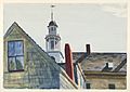
Edward Hopper, Universalist Church, 1926, Princeton University Art Museum
.jpg)
See also
 In Spanish: Gloucester (Massachusetts) para niños
