
Goessel, Kansas facts for kids
Quick facts for kids
Goessel, Kansas
|
|
|---|---|

Alexanderwohl Mennonite Church
1 mile north of Goessel (2007) |
|

Location within Marion County and Kansas
|
|

|
|
| Country | United States |
| State | Kansas |
| County | Marion |
| Township | West Branch |
| Platted | 1910 |
| Incorporated | 1952 |
| Government | |
| • Type | Mayor–Council |
| Area | |
| • Total | 0.38 sq mi (0.98 km2) |
| • Land | 0.38 sq mi (0.98 km2) |
| • Water | 0.00 sq mi (0.00 km2) |
| Elevation | 1,532 ft (467 m) |
| Population
(2020)
|
|
| • Total | 556 |
| • Density | 1,463/sq mi (567/km2) |
| Time zone | UTC-6 (CST) |
| • Summer (DST) | UTC-5 (CDT) |
| ZIP code |
67053
|
| Area code | 620 |
| FIPS code | 20-26750 |
| GNIS ID | 477764 |
Goessel is a city in Marion County, Kansas, United States. It was named after Captain (1852–1895) who went down with his ship, the Elbe, in the English Channel after it was rammed. As of the 2020 census, the population of the city was 556. It is located about 11 miles north of North Newton on the west side of K-15 highway.
History

Early history
For many millennia, the Great Plains of North America was inhabited by nomadic Native Americans. From the 16th century to 18th century, the Kingdom of France claimed ownership of large parts of North America. In 1762, after the French and Indian War, France secretly ceded New France to Spain, per the Treaty of Fontainebleau.
19th century
In 1802, Spain returned most of the land to France. In 1803, most of the land for modern day Kansas was acquired by the United States from France as part of the 828,000 square mile Louisiana Purchase for 2.83 cents per acre.
In 1854, the Kansas Territory was organized, then in 1861 Kansas became the 34th U.S. state. In 1855, Marion County was established within the Kansas Territory, which included the land for modern day Goessel.
The year 1874 saw the first wave of an immigration of German-speaking Russian Mennonite to south-central Kansas. The move was an attempt to preserve religious heritage and freedom after exclusion from military service was rescinded. During the next decade, one-third of Mennonites in Russia moved to North America. In 1874 a large portion of the Russian village of Alexanderwohl immigrated en masse to the United States aboard the ships Teutonia and Cimbria. This group split into two groups, the Alexanderwohl group sailed on the Cimbria then located around present day Goessel, and the Hoffnungsau group sailed on the Teutonia then located around present day Buhler and Inman.
The Alexanderwohl group split into eight communal villages. The village of Gnadenfeld (translation is Grace Field) was located where Goessel now stands. The village lasted for several years as a communal village then families moved onto their own larger parcels of land nearby. Several years passed before a trading center developed. The first public structure erected in Goessel was the Mennonite Brethren church in 1890. One of the first businesses was a creamery station in the same year. In 1891, a small mercantile store was opened, then in the same year Dr. Peter Richert moved a building that was used as his doctor's office, then later it became a post office. Dr. Richert read the story of Captain Kurt von Goessel, who went down with his steamship Elbe in the English Channel. Dr. Richert decided to submit the name Goessel to the U.S. Postal Department, and it was accepted on April 13, 1895.
20th century

In 1910, Goessel was platted and had a population of 100 people. In 1952, Goessel was incorporated and had a population of 260. In 2010, the United States Census reported 248 households and a population of 539.
Goessel is home to the Mennonite Heritage Museum, a complex of eight buildings which preserve artifacts from early Mennonite households, farms, schools, churches and the Bethesda Mennonite Hospital.
Geography
Goessel is located at 38°14′49″N 97°20′53″W / 38.246972°N 97.348178°W (38.246972, -97.348178). According to the United States Census Bureau, the city has a total area of 0.35 square miles (0.91 km2), all of it land. The county line is 1 mile west of Goessel.
Climate
The climate in this area is characterized by hot, humid summers and generally mild to cool winters with very cold periods.
Area events
- Goessel Threshing Days, located at Mennonite Heritage and Agricultural Museum. 37th annual in 2010. Old-fashioned threshing demonstration and show with more than 100 exhibitors from a 7-state area display and demonstrate antique equipment related to farming during the past century. Numerous antique tractors are displayed. Ethnic Mennonite food is available.
- Goessel Harvest Festival.
Area attractions
- Mennonite Heritage and Agricultural Museum, 200 N Poplar St. The Mennonite Heritage Museum was dedicated in 1974. It is a museum of artifacts of the Mennonites that settled in the Goessel area. The museum has eight buildings that show the life of the immigrants that moved to Goessel.
- Alexanderwohl Mennonite Church, 1 mi north on K-15 Highway.
- Kansas Historical Marker - The Mennonites In Kansas, 1 mi north on K-15 Highway.
Demographics
| Historical population | |||
|---|---|---|---|
| Census | Pop. | %± | |
| 1960 | 327 | — | |
| 1970 | 386 | 18.0% | |
| 1980 | 421 | 9.1% | |
| 1990 | 506 | 20.2% | |
| 2000 | 565 | 11.7% | |
| 2010 | 539 | −4.6% | |
| 2020 | 556 | 3.2% | |
| U.S. Decennial Census | |||
2010 census
As of the census of 2010, there were 539 people, 206 households, and 140 families residing in the city. The population density was 1,540.0 inhabitants per square mile (594.6/km2). There were 231 housing units at an average density of 660.0 per square mile (254.8/km2). The racial makeup of the city was 97.0% White, 0.2% African American, 0.4% Native American, 0.9% from other races, and 1.5% from two or more races. Hispanic or Latino of any race were 2.0% of the population.
There were 206 households, of which 28.2% had children under the age of 18 living with them, 57.8% were married couples living together, 7.3% had a female householder with no husband present, 2.9% had a male householder with no wife present, and 32.0% were non-families. 30.1% of all households were made up of individuals, and 18% had someone living alone who was 65 years of age or older. The average household size was 2.36 and the average family size was 2.91.
The median age in the city was 48.6 years. 22.6% of residents were under the age of 18; 5.1% were between the ages of 18 and 24; 18.9% were from 25 to 44; 23.4% were from 45 to 64; and 30.1% were 65 years of age or older. The gender makeup of the city was 45.8% male and 54.2% female.
Gallery
-
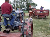
Wheat Threshing Demo at Goessel Threshing Days (August 7, 2010)
-
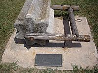
Threshing stone near Alexanderwohl Mennonite Church (2011)
-
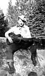
Karl Unruh (1945)


Education
Public
The community is served by Goessel USD 411 public school district.
- Goessel High School, 100 E Main St.
- Goessel Junior High School, 100 E Main St.
- Goessel Elementary School, 500 E Main St.
Sports
The Goessel High School mascot is a Bluebird. All high school athletic and non-athletic competition is overseen by the Kansas State High School Activities Association. For 2010/2011 seasons, the football team competes as Class 8 Man - Division I.
Past Championships:
- 1976 Boys Cross Country - Class 1A
- 1988 Boys Basketball - Class 1A
Library
Each USD 411 school has a library for student access.
The city is served by the Goessel City Library at 101 South Cedar Street. The library is a member of the North Central Kansas Libraries System, which provides an inter-library book loan service for its members.
Infrastructure
Transportation
K-15 highway runs along the east side of the city.
Utilities
- Internet
- DSL is provided by Moundridge Telephone Company.
- Wireless is provided by Pixius Communications.
- Satellite is provided by HughesNet, StarBand, WildBlue.
- TV
- Cable is provided by Moundridge Telephone Company.
- Satellite is provided by DirecTV, Dish Network.
- Terrestrial is provided by regional digital TV stations.
- Phone
- Landline is provided by Moundridge Telephone Company.
- Electricity
- City is provided by Westar Energy.
- Rural is provided by Westar Energy and Flint Hills RECA.
- Natural Gas
- Service is provided by Kansas Gas Service.
- Water
- City is provided by Marion County RWD #4, billed by City of Goessel.
- Rural is provided by Marion County RWD #4 (map) and Harvey County RWD #1 (map).
- Sewer
- Service is provided by City of Goessel.
- Trash
- Service is provided by City of Goessel.
Notable people
- Duane A. Goossen, (born 1955), Kansas House of Representatives, Contractor
- Shirley Knight, (1936-2020), American stage, screen, and television actress. Academy Award-nominated actress.
- Duane D. Thiessen, (born 1951), Major General, United States Marine Corps.
See also
 In Spanish: Goessel para niños
