
Gogebic County, Michigan facts for kids
Quick facts for kids
Gogebic County
|
||
|---|---|---|

Gogebic County Courthouse, July 2014
|
||
|
||

Location within the U.S. state of Michigan
|
||
 Michigan's location within the U.S. |
||
| Country | ||
| State | ||
| Founded | 1887 | |
| Named for | Lake Gogebic | |
| Seat | Bessemer | |
| Largest city | Ironwood | |
| Area | ||
| • Total | 1,476 sq mi (3,820 km2) | |
| • Land | 1,102 sq mi (2,850 km2) | |
| • Water | 374 sq mi (970 km2) 25%% | |
| Population
(2020)
|
||
| • Total | 14,380 | |
| • Density | 15/sq mi (6/km2) | |
| Time zone | UTC−6 (Central) | |
| • Summer (DST) | UTC−5 (CDT) | |
| Congressional district | 1st | |
Gogebic County ( goh-GHIB-ik) is the westernmost county in the Upper Peninsula in the U.S. state of Michigan. As of the 2020 Census, the population was 14,380. The county seat is Bessemer. This was historically part of the territory of the Lake Superior Band of Chippewa, which had twelve bands in Michigan, Wisconsin and Minnesota. The Lac Vieux Desert Indian Reservation is in this county, in Watersmeet Township; it is the land base of one of the federally recognized tribes.
Gogebic County was organized in 1887, partitioned from Ontonagon County. The county's name derives from a lake of the same name, which was originally rendered Agogebic. Sources agree that the name is from Ojibwe, but differ on the original meaning. The county's website suggests it meant "body of water hanging on high," but an 1884 military annal said it meant "water-mold lake" (Agogibing). (See also: List of place names of Native American origin in Michigan)
Contents
Geography

According to the U.S. Census Bureau, the county has a total area of 1,476 square miles (3,820 km2), of which 1,102 square miles (2,850 km2) is land and 374 square miles (970 km2) (25%) is water.
Water features
- Lake Superior
- Lake Gogebic is the largest lake in the Upper Peninsula.
- Montreal River is on the western edge of the county on the Wisconsin border
Adjacent counties
- Ontonagon County (north/east Border)
- Iron County (east)
- Vilas County, Wisconsin (south)
- Iron County, Wisconsin (southwest)
- Ashland County, Wisconsin (northwest)
National protected area
- Ottawa National Forest (part)
State protected area
Demographics
| Historical population | |||
|---|---|---|---|
| Census | Pop. | %± | |
| 1890 | 13,166 | — | |
| 1900 | 16,738 | 27.1% | |
| 1910 | 23,333 | 39.4% | |
| 1920 | 33,225 | 42.4% | |
| 1930 | 31,577 | −5.0% | |
| 1940 | 31,797 | 0.7% | |
| 1950 | 27,053 | −14.9% | |
| 1960 | 24,370 | −9.9% | |
| 1970 | 20,676 | −15.2% | |
| 1980 | 19,686 | −4.8% | |
| 1990 | 18,052 | −8.3% | |
| 2000 | 17,370 | −3.8% | |
| 2010 | 16,427 | −5.4% | |
| 2020 | 14,380 | −12.5% | |
| U.S. Decennial Census 1790-1960 1900-1990 1990-2000 2010-2018 |
|||
The 2010 United States Census indicates Gogebic County had a population of 16,427. This decrease of 943 people from the 2000 United States Census is a -5.4% change in population. In 2010 there were 7,037 households and 4,171 families residing in the county. The population density was 15 people per square mile (6/km2). There were 10,795 housing units at an average density of 10 per square mile (4/km2). 91.7% of the population were White, 4.1% Black or African American, 2.4% Native American, 0.2% Asian, 0.2% of some other race and 1.4% of two or more races. 0.9% were Hispanic or Latino (of any race). 17.4% were of Finnish, 12.8% German, 11.2% American, 10.0% Italian, 6.8% Polish, 6.7% English and 5.1% Irish ancestry.
There were 7,037 households, out of which 20.6% had children under the age of 18 living with them, 45.4% were married couples living together, 9.3% had a female householder with no husband present, and 40.7% were non-families. 35.3% of all households were made up of individuals, and 16.5% had someone living alone who was 65 years of age or older. The average household size was 2.11 and the average family size was 2.69.
The county population was 16.9% under the age of 18, 8.4% from 18 to 24, 22.2% from 25 to 44, 31.1% from 45 to 64, and 21.5% who were 65 years of age or older. The median age was 46.8 years. 53.3% of the population was male, and 46.7% of the population was female.
The median income for a household in the county was $34,917, and the median income for a family was $47,219. The per capita income for the county was $20,759. About 14.0% of families and 17.2% of the population were below the poverty line, including 28.6% of those under age 18 and 9.0% of those age 65 or over.
Transportation
Major highways
 US 2
US 2
Bus. US 2 serves the city of Ironwood. US 45
US 45 M-28
M-28 M-64
M-64
Airport
- KIWD - Gogebic-Iron County Airport – 7 miles (13 km) NE of Ironwood. Commercial air service is available.
Communities

Cities
Townships
- Bessemer
- Erwin
- Ironwood
- Marenisco
- Wakefield
- Watersmeet
Census-designated places
Other unincorporated communities
Images for kids
-
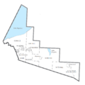
U.S. Census data map showing local municipal boundaries within Gogebic County. Shaded areas represent incorporated cities.

See also
 In Spanish: Condado de Gogebic para niños
