
Grand Rapids, Minnesota facts for kids
Quick facts for kids
Grand Rapids
|
|
|---|---|
| Motto(s):
"It's In Minnesota's Nature"
|
|

Location of Grand Rapids
in Itasca County and Minnesota |
|
| Country | United States |
| State | Minnesota |
| County | Itasca |
| Founded | c. 1872 |
| Incorporated (village) | June 9, 1891 |
| Government | |
| • Type | Mayor – Council |
| Area | |
| • Total | 24.46 sq mi (63.36 km2) |
| • Land | 22.57 sq mi (58.46 km2) |
| • Water | 1.89 sq mi (4.90 km2) |
| Elevation | 1,289 ft (393 m) |
| Population
(2010)
|
|
| • Total | 10,869 |
| • Estimate
(2019)
|
11,214 |
| • Density | 496.81/sq mi (191.82/km2) |
| Time zone | UTC−6 (Central (CST)) |
| • Summer (DST) | UTC−5 (CDT) |
| ZIP codes |
55730, 55744, 55745
|
| Area code(s) | 218 |
| FIPS code | 27-25118 |
| GNIS feature ID | 0656428 |
Grand Rapids is a city in and the county seat of Itasca County, Minnesota, United States. The population was 10,869 at the 2010 census. The city is named for the 3.5-mile (5.6 km) long local rapids in the Mississippi River, which was the uppermost limit of practical steamboat travel during the late 19th century. Today the rapids are hidden below the dam of the Blandin Paper Mill.
Contents
History
Grand Rapids was founded as a logging town, as the Mississippi River provided an optimal method of log shipment to population centers. The predecessor of the Blandin paper mill opened in 1902.
The town was also the childhood home of Judy Garland, born Frances Ethel Gumm.
The Forest History Center is a State Historic Site and a living history museum that recreates life as it was in a turn of the 20th century logging camp. Costumed interpreters guide visitors through a recreated circa 1890s logging camp to educate the public on the history of white pine logging and its relevance to today's economy. Miles of nature trails, educational naturalist programming, and an interpretive museum are also located on the site.
Old Central School, located in downtown Grand Rapids, was built in 1895 in the Richardsonian Romanesque style of architecture. The three story building served as an elementary school from 1895 to 1972. A community effort restored the building in 1984 and it now serves as a location for commerce and is listed on the National Register of Historic Places.
Geography
According to the United States Census Bureau, the city has a total area of 24.44 square miles (63.30 km2), of which 22.56 square miles (58.43 km2) is land and 1.88 square miles (4.87 km2) is water.
Grand Rapids is the county seat of Itasca County, a county that contains over 1000 lakes.
The city of Grand Rapids sits at the junction of U.S. Highways 2 and 169. U.S. Highway 2 runs west towards Bemidji and east towards Duluth. U.S. Highway 169 heads south to Hill City, and ultimately towards the city of Minneapolis. In the other direction, U.S. Highway 169 heads up the Mesabi Range until it reaches the city of Virginia, passing through Hibbing and several other smaller towns along the way. Grand Rapids is also the starting point of State Highway 38, running 47 miles (76 km) north along the Edge of the Wilderness Scenic Byway towards Effie. State Highway 38 has been designated a National Scenic Byway by the United States Department of Transportation.
Major highways
The following routes are located within the city of Grand Rapids.
 U.S. Highway 2
 U.S. Highway 169
 Minnesota State Highway 38 – Edge of the Wilderness Scenic Byway
Climate
The city of Grand Rapids has a Humid continental climate (Köppen Climate Classification Dfb) with warm summers and long, cold winters, typical of its location on the Mesabi Iron Range.
| Climate data for Grand Rapids, Minnesota (1981–2010) | |||||||||||||
|---|---|---|---|---|---|---|---|---|---|---|---|---|---|
| Month | Jan | Feb | Mar | Apr | May | Jun | Jul | Aug | Sep | Oct | Nov | Dec | Year |
| Record high °F (°C) | 51 (11) |
61 (16) |
80 (27) |
93 (34) |
101 (38) |
100 (38) |
104 (40) |
100 (38) |
99 (37) |
89 (32) |
71 (22) |
59 (15) |
104 (40) |
| Average high °F (°C) | 19.4 (−7.0) |
26.3 (−3.2) |
38.5 (3.6) |
54.3 (12.4) |
67.0 (19.4) |
75.5 (24.2) |
80.2 (26.8) |
78.2 (25.7) |
67.9 (19.9) |
53.8 (12.1) |
36.6 (2.6) |
22.5 (−5.3) |
51.7 (10.9) |
| Average low °F (°C) | −2.7 (−19.3) |
2.3 (−16.5) |
16.1 (−8.8) |
29.7 (−1.3) |
41.4 (5.2) |
51.1 (10.6) |
56.0 (13.3) |
54.1 (12.3) |
44.9 (7.2) |
33.3 (0.7) |
20.1 (−6.6) |
4.2 (−15.4) |
29.2 (−1.6) |
| Record low °F (°C) | −51 (−46) |
−45 (−43) |
−39 (−39) |
−10 (−23) |
11 (−12) |
24 (−4) |
33 (1) |
27 (−3) |
15 (−9) |
−3 (−19) |
−25 (−32) |
−45 (−43) |
−51 (−46) |
| Average precipitation inches (mm) | 0.92 (23) |
0.64 (16) |
1.31 (33) |
2.06 (52) |
3.07 (78) |
4.37 (111) |
4.29 (109) |
3.41 (87) |
3.31 (84) |
2.81 (71) |
1.61 (41) |
1.07 (27) |
28.87 (733) |
| Average snowfall inches (cm) | 12.3 (31) |
7.2 (18) |
7.7 (20) |
3.8 (9.7) |
0.2 (0.51) |
0 (0) |
0 (0) |
0 (0) |
— | 1.5 (3.8) |
9.4 (24) |
11.7 (30) |
54.4 (138) |
| Average precipitation days (≥ 0.01 in) | 10 | 9 | 9 | 9 | 12 | 13 | 12 | 10 | 12 | 11 | 10 | 11 | 128 |
| Average snowy days (≥ 0.1 in) | 11 | 8 | 6 | 3 | 0 | 0 | 0 | 0 | 0 | 1 | 7 | 11 | 48 |
| Source: NOAA (extremes 1915–present) | |||||||||||||
Demographics
| Historical population | |||
|---|---|---|---|
| Census | Pop. | %± | |
| 1900 | 1,428 | — | |
| 1910 | 2,230 | 56.2% | |
| 1920 | 2,914 | 30.7% | |
| 1930 | 3,205 | 10.0% | |
| 1940 | 4,875 | 52.1% | |
| 1950 | 6,019 | 23.5% | |
| 1960 | 7,265 | 20.7% | |
| 1970 | 7,247 | −0.2% | |
| 1980 | 7,934 | 9.5% | |
| 1990 | 7,976 | 0.5% | |
| 2000 | 7,764 | −2.7% | |
| 2010 | 10,869 | 40.0% | |
| 2019 (est.) | 11,214 | 3.2% | |
| U.S. Decennial Census | |||
2010 census
As of the census of 2010, there were 10,869 people, 4,615 households, and 2,633 families living in the city. The population density was 481.8 inhabitants per square mile (186.0/km2). There were 4,910 housing units at an average density of 217.6 per square mile (84.0/km2). The racial makeup of the city was 94.6% White, 0.6% African American, 1.9% Native American, 0.6% Asian, 0.3% from other races, and 2.0% from two or more races. Hispanic or Latino of any race were 1.2% of the population.
There were 4,615 households, of which 26.6% had children under the age of 18 living with them, 41.1% were married couples living together, 12.4% had a female householder with no husband present, 3.6% had a male householder with no wife present, and 42.9% were non-families. 36.5% of all households were made up of individuals, and 17.1% had someone living alone who was 65 years of age or older. The average household size was 2.20 and the average family size was 2.84.
The median age in the city was 42 years. 22.2% of residents were under the age of 18; 8.5% were between the ages of 18 and 24; 22.4% were from 25 to 44; 26% were from 45 to 64; and 20.8% were 65 years of age or older. The gender makeup of the city was 47.5% male and 52.5% female.
Religion
Churches in Grand Rapids include St. Luke's Evangelical Lutheran Church, member of the Wisconsin Evangelical Lutheran Synod (WELS); St. Andrew's Lutheran Church and Zion Lutheran Churches, members of the Evangelical Lutheran Church in America (ELCA); and St. Joseph's Roman Catholic Church.
Economy
Historically, the local economy was based on timber harvesting, and to this day, Blandin Paper Mill, now owned by the Finnish-based UPM paper company, has its papermaking facilities in downtown Grand Rapids, while Ainsworth (formerly Potlach) located just outside the city limits, produced oriented strand board until it ceased operation in September 2006.
The Mesabi Range or Iron Range region of Minnesota begins with one iron mine to the southwest and a number to the northeast of the city. Although technically and geographically a member of the Iron Range, Grand Rapids and its economy has been historically based on paper manufacturing and other wood products. Its current economy also has a large tourist footing, with many local resorts, four golf courses, over one million acres (4,000 km2) of public and industrial forestlands that provide excellent regional hunting, and more than 1,000 lakes for fishing. It also is the service center for 46,000 people due to a large seasonal and weekend population of summer residences on surrounding lakes, and a number of smaller bedroom communities located near Grand Rapids.
Annual tourism events
- Home & Cabin Show - March
- White Oak Classic Dog Sled Race – March
- Children's Fair - April
- Bluegrass Music in the Pines Festival - June
- Wizard of Oz Festival – June
- Timberman Triathlon - July
- Northern Mn Swap Meet & Car Show – July
- Tall Timber Days – August
- Grand Slam of Golf Tournament – August
- Threshing & Antique Show - August
- Bargains are Great on 38 - September
- National Ruffed Grouse Society Annual Hunt – October
- WinterGlo Festival - December
Education
Schools in ISD 318 include:
- West Elementary
- Southwest Elementary
- East Elementary
- Murphy Elementary
- St. Joseph's Elementary
- Cohasset Elementary
- Robert J. Elkington Middle School
- Grand Rapids High School
- Bigfork School in Bigfork
Grand Rapids also has the following parochial and secondary schools:
- Itasca Community College
- St. Joseph's Catholic School
Notable people

- Bill Baker, member of the Miracle on Ice 1980 U.S. Olympic Hockey Team
- Hugh Beaumont, known for Leave it to Beaver
- Jon Casey, professional hockey player for the Minnesota North Stars
- Judy Garland, iconic actress and singer, born June 10, 1922, in Grand Rapids
- Alex Goligoski, current professional hockey player for the Arizona Coyotes
- Lois Hall, actress
- Spencer Igo, member of the Minnesota House of Representatives
- Trent Klatt, played in NHL
- Robert N. Lemen, member of the Minnesota House of Representatives
- Don Lucia, hockey coach at the University of Minnesota
- Jeff Nielsen, professional hockey player for the Minnesota Wild
- Norman Ornstein, political scientist
- Jim Pehler, Minnesota state legislator
- Dick Pesonen, professional football player
- Janelle Pierzina, Big Brother television series cast member
- Norman Rudolph Prahl, Minnesota state legislator
- Jon Rohloff, professional hockey player for the Boston Bruins
- Dusty Rychart, basketball player for the Cairns Taipans
- Granville Van Dusen, actor
Images for kids
-
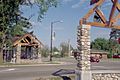
The gateway to the Edge of the Wilderness Scenic Byway in Grand Rapids welcomes visitors to one of the terminus towns of the Byway.
-
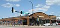
Shops in downtown Grand Rapids
-
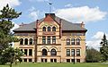
The Old Central School, now a mall and civic center


See also
 In Spanish: Grand Rapids (Minnesota) para niños
