Grant County, Indiana facts for kids
Quick facts for kids
Grant County
|
|
|---|---|

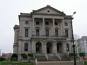
Grant County Courthouse in Marion
|
|

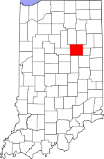
Location within the U.S. state of Indiana
|
|
 Indiana's location within the U.S. |
|
| Country | |
| State | |
| Founded | 1831 |
| Named for | Samuel and Moses Grant |
| Seat | Marion |
| Largest city | Marion |
| Area | |
| • Total | 414.90 sq mi (1,074.6 km2) |
| • Land | 414.07 sq mi (1,072.4 km2) |
| • Water | 0.82 sq mi (2.1 km2) 0.20%% |
| Population | |
| • Estimate
(2018)
|
65,936 |
| • Density | 159/sq mi (61.4/km2) |
| Time zone | UTC−5 (Eastern) |
| • Summer (DST) | UTC−4 (EDT) |
| Congressional district | 5th |
| Indiana county number 27 | |
Grant County is a county in central Indiana in the United States Midwest. At the time of the 2010 census, the population was 70,061. The county seat is Marion. Important paleontological discoveries, dating from the Pliocene epoch, have been made at the Pipe Creek Sinkhole in Grant County.
Contents
History
Grant County was formed in 1831. It was named for Captains Samuel and Moses Grant of Kentucky.
The above-named book does state that Grant County, Indiana is named for Samuel and Moses Grant of Kentucky, killed in battle with the Indians. HOWEVER, the next entry states that Grant County, Kentucky, according to John McGee was named for Col. John Grant, an early settler, but according to J. Worthing McCann, the county was named for Samuel Grant. Samuel and his brother Moses were killed by Indians just north of the Ohio River. Their home was in Kentucky and their home county was named in memory of them - Grant County, Kentucky.
In 1831, Martin Boots and David Branson each donated 30 acres of land to begin a settlement called Marion. This land was on the north side of a fast-flowing and scenic river the Miami Indians called Mississinewa -"laughing Waters." Thus Grant County was formed with Marion as the County Seat. http://grantcounty.com/about-gc/history/
Stephen Johnson became Grant County first full time prosecutor and served for five cosecutive terms 1983 through 2002.
Geography
According to the 2010 census, the county has a total area of 414.90 square miles (1,074.6 km2), of which 414.07 square miles (1,072.4 km2) (or 99.80%) is land and 0.82 square miles (2.1 km2) (or 0.20%) is water.

Adjacent counties
- Huntington County (northeast)
- Wells County (east-northeast)
- Blackford County (east-southeast)
- Delaware County (southeast)
- Madison County (south)
- Tipton County (southwest)
- Howard County (west-southwest)
- Miami County (west-northwest)
- Wabash County (northwest)
Major highways
Interstates
 I-69
I-69
U.S. Highways
 US 35
US 35
Indiana State Roads
 SR 5
SR 5 SR 9
SR 9 SR 13
SR 13 SR 15
SR 15 SR 18
SR 18 SR 19
SR 19 SR 22
SR 22 SR 26
SR 26 SR 37
SR 37
Climate and weather
| Weather chart for Marion, Indiana | |||||||||||||||||||||||||||||||||||||||||||||||
|---|---|---|---|---|---|---|---|---|---|---|---|---|---|---|---|---|---|---|---|---|---|---|---|---|---|---|---|---|---|---|---|---|---|---|---|---|---|---|---|---|---|---|---|---|---|---|---|
| J | F | M | A | M | J | J | A | S | O | N | D | ||||||||||||||||||||||||||||||||||||
|
2.2
32
16
|
2
37
19
|
3
48
28
|
3.6
60
38
|
4.3
72
49
|
3.9
81
59
|
4.7
85
63
|
3.7
82
61
|
2.8
76
53
|
2.6
64
42
|
3.4
50
33
|
2.9
37
22
|
||||||||||||||||||||||||||||||||||||
| temperatures in °F precipitation totals in inches source: The Weather Channel |
|||||||||||||||||||||||||||||||||||||||||||||||
|
Metric conversion
|
|||||||||||||||||||||||||||||||||||||||||||||||
In recent years, average temperatures in Marion have ranged from a low of 16 °F (−9 °C) in January to a high of 85 °F (29 °C) in July, although a record low of −23 °F (−31 °C) was recorded in January 1985 and a record high of 108 °F (42 °C) was recorded in July 1936. Average monthly precipitation ranged from 2.03 inches (52 mm) in February to 4.73 inches (120 mm) in July.
Demographics
| Historical population | |||
|---|---|---|---|
| Census | Pop. | %± | |
| 1840 | 4,875 | — | |
| 1850 | 11,092 | 127.5% | |
| 1860 | 15,797 | 42.4% | |
| 1870 | 18,487 | 17.0% | |
| 1880 | 23,618 | 27.8% | |
| 1890 | 31,493 | 33.3% | |
| 1900 | 54,693 | 73.7% | |
| 1910 | 51,426 | −6.0% | |
| 1920 | 51,353 | −0.1% | |
| 1930 | 51,066 | −0.6% | |
| 1940 | 55,813 | 9.3% | |
| 1950 | 62,156 | 11.4% | |
| 1960 | 75,741 | 21.9% | |
| 1970 | 83,955 | 10.8% | |
| 1980 | 80,934 | −3.6% | |
| 1990 | 74,169 | −8.4% | |
| 2000 | 73,403 | −1.0% | |
| 2010 | 70,061 | −4.6% | |
| 2018 (est.) | 65,936 | −5.9% | |
| US Decennial Census 1790-1960 1900-1990 1990-2000 2010-2013 |
|||
2010 United States Census
As of the 2010 United States Census, there were 70,061 people, 27,245 households, and 18,000 families in the county. The population density was 169.2 inhabitants per square mile (65.3/km2). There were 30,443 housing units at an average density of 73.5 per square mile (28.4/km2). The racial makeup of the county was 88.2% white, 7.0% black or African American, 0.6% Asian, 0.3% American Indian, 1.4% from other races, and 2.4% from two or more races. Those of Hispanic or Latino origin made up 3.6% of the population. In terms of ancestry, 19.5% were German, 12.4% were American, 10.0% were Irish, and 9.0% were English.
Of the 27,245 households, 29.4% had children under the age of 18 living with them, 48.0% were married couples living together, 13.4% had a female householder with no husband present, 33.9% were non-families, and 28.8% of all households were made up of individuals. The average household size was 2.39 and the average family size was 2.89. The median age was 39.5 years.
The median income for a household in the county was $47,697 and the median income for a family was $49,860. Males had a median income of $40,146 versus $28,588 for females. The per capita income for the county was $19,792. About 12.0% of families and 17.0% of the population were below the poverty line, including 25.0% of those under age 18 and 9.4% of those age 65 or over.
Localities
Cities
Towns
Census-designated places
Other unincorporated place
Townships
- Center
- Fairmount
- Franklin
- Green
- Jefferson
- Liberty
- Mill
- Monroe
- Pleasant
- Richland
- Sims
- Van Buren
- Washington
See also
 In Spanish: Condado de Grant (Indiana) para niños

