
Granville, Massachusetts facts for kids
Quick facts for kids
Granville, Massachusetts
|
||
|---|---|---|

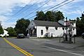
Old Meeting House
|
||
|
||

Location in Hampden County in Massachusetts
|
||
| Country | United States | |
| State | Massachusetts | |
| County | Hampden | |
| Settled | 1736 | |
| Incorporated | 1754 | |
| Government | ||
| • Type | Open town meeting | |
| Area | ||
| • Total | 43.0 sq mi (111.4 km2) | |
| • Land | 42.2 sq mi (109.3 km2) | |
| • Water | 0.8 sq mi (2.1 km2) | |
| Elevation | 685 ft (209 m) | |
| Population
(2020)
|
||
| • Total | 1,538 | |
| • Density | 35.758/sq mi (13.806/km2) | |
| Time zone | UTC−5 (Eastern) | |
| • Summer (DST) | UTC−4 (Eastern) | |
| ZIP Code |
01034
|
|
| Area code(s) | 413 | |
| FIPS code | 25-26675 | |
| GNIS feature ID | 0618183 | |

Granville is a town in Hampden County, Massachusetts, United States. The population was 1,538 at the 2020 census. It is part of the Springfield, Massachusetts Metropolitan Statistical Area. The town is named for John Carteret, 2nd Earl Granville.
Contents
History and description
Granville was first settled by English colonists in 1736 and was officially incorporated in 1754, after the end of the Indian wars in 1750. Early settlers could get a 100-acre (0.40 km2) lot for free, providing they built a house and "put four acres in English hay". Perhaps the most famous resident of that era was Oliver Phelps, whose purchase of 6 million acres (24,000 km2) in western New York (Phelps and Gorham Purchase) following the American Revolutionary War remains the largest real estate purchase in US history. The population in Granville expanded quickly, peaking at 2100 in 1810, when it rivaled Springfield. However, likely due to the rocky soil in New England, many settlers eventually migrated west, some establishing the town of Granville, Ohio.
Many historic homes dot Route 57, the main road through town. The village center, the old center, and West Granville center, are all designated as historic districts listed on the National Register of Historic Places. Historic buildings include Granville's Old Meeting House (superb acoustics), the Stevenson house to its west, the West Granville Academy, and the West Granville Church. The village center features an old-fashioned country store, known for its cellar-aged cheese.
In addition to period architecture, Granville is the watershed for three reservoirs: Barkhamsted, the main source for the Hartford metropolitan district; Cobble Mountain, the main source for the city of Springfield; and Westfield, the main source for the city of Westfield, Massachusetts. Much of the land in town is owned by the various water districts. Granville also has a number of active apple orchards.
Geography
According to the United States Census Bureau, the town has a total area of 43.0 square miles (111 km2), of which 42.2 square miles (109 km2) is land and 0.7 square miles (1.8 km2) (1.70%) is water.
Granville is bordered on the north by Blandford and Russell, on the northeast by Westfield, on the east by Southwick, on the south by Granby, Connecticut and Hartland, Connecticut, and on the west by Tolland.
Demographics
| Historical population | ||
|---|---|---|
| Year | Pop. | ±% |
| 1850 | 1,305 | — |
| 1860 | 1,385 | +6.1% |
| 1870 | 1,293 | −6.6% |
| 1880 | 1,205 | −6.8% |
| 1890 | 1,061 | −12.0% |
| 1900 | 1,050 | −1.0% |
| 1910 | 781 | −25.6% |
| 1920 | 655 | −16.1% |
| 1930 | 674 | +2.9% |
| 1940 | 668 | −0.9% |
| 1950 | 740 | +10.8% |
| 1960 | 874 | +18.1% |
| 1970 | 1,008 | +15.3% |
| 1980 | 1,204 | +19.4% |
| 1990 | 1,403 | +16.5% |
| 2000 | 1,521 | +8.4% |
| 2010 | 1,566 | +3.0% |
| 2010 | 1,538 | −1.8% |
Source: United States Census records and Population Estimates Program data. |
||
As of the census of 2000, there were 1,521 people, 556 households, and 409 families residing in the town. The population density was 36.0 people per square mile (13.9/km2). There were 595 housing units at an average density of 14.1 per square mile (5.4/km2). The racial makeup of the town was 98.69% White, 0.26% African American, 0.20% Asian, 0.39% from other races, and 0.46% from two or more races. Hispanic or Latino of any race were 0.66% of the population.
There were 556 households, out of which 36.9% had children under the age of 18 living with them, 63.7% were married couples living together, 6.8% had a female householder with no husband present, and 26.3% were non-families. Of all households 20.9% were made up of individuals, and 8.8% had someone living alone who was 65 years of age or older. The average household size was 2.73 and the average family size was 3.19.
In the town, the population was spread out, with 27.6% under the age of 18, 4.9% from 18 to 24, 31.1% from 25 to 44, 25.4% from 45 to 64, and 10.9% who were 65 years of age or older. The median age was 39 years. For every 100 females, there were 106.9 males. For every 100 females age 18 and over, there were 100.9 males.
The median income for a household in the town was $53,148, and the median income for a family was $59,219. Males had a median income of $42,273 versus $30,380 for females. The per capita income for the town was $22,315. About 1.8% of families and 3.4% of the population were below the poverty line, including 1.0% of those under age 18 and 9.8% of those age 65 or over.
-
Granville Country Store
-
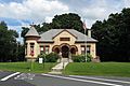
Granville Public Library
-
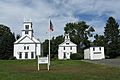
Congregational Church, West Granville
-
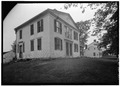
Historic Scott House
-
Granville State Forest


Library
The Granville public library began in 1894. In fiscal year 2008, the town of Granville spent 0.68% ($31,979) of its budget on its public library—some $18 per person.
Points of interest
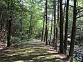
- Granville State Forest
- Granville Center Historic District
- Granville Village Historic District
- Nobel & Cooley Drum Factory
- West Granville Historic District
- Wild Cat Aqueduct
Annual events
Granville Harvest Fair
Running through Columbus Day weekend in October, Granville's Harvest Fair attracts vendors and people from all over New England. The fair stretches all along route 57 from the Granville Village School to the Granville Town Hall (1.4 miles) and has shops lining the streets with a majority of the fair centered at the school, town hall and the town green. A busing system would travel between these three points, however, as of 2012 the fair removed the town hall from being the last stop in exchange for the Nobel and Cooley Drum Factory located on Water St. This reduced the overall travel length of the buses in half from 1.4 miles to 0.7 mile. The fair itself is primarily a crafts fair with most vendors selling handmade goods.
Education
Granville is part of the Southwick Regional School District, along with Southwick, and Tolland. Students attend Woodland School from K–2, and Powder Mill School from 3–6. High School students attend Southwick Regional School from 7–12.
Notable people
- Israel Barlow (1806–1883), Latter-day Saint pioneer, co-founder of Nauvoo, Illinois
- Samuel L. M. Barlow, Sr. (1826–1889), politician
- Isaac Chapman Bates (1779–1845), politician
- Lemuel Haynes (1753–1833), African American religious leader
- Daniel Penfield (1759–1840), merchant, soldier, town founder
- Oliver Phelps (1749–1809), merchant and politician
- Austin Scott (1848–1922), historian and college president
- Seward Smith (1830–1886?), lawyer, politician, and judge
- Sabrina Tavernise (born 1971), journalist
See also
 In Spanish: Granville (Massachusetts) para niños
