
Grass Valley, California facts for kids
Quick facts for kids
City of Grass Valley
|
|
|---|---|

The historic Holbrooke Hotel and Restaurant
|
|

Location of Grass Valley in Nevada County, California
|
|

Grass Valley, California
Location in the United States
|
|
| Country | United States |
| State | California |
| County | Nevada |
| Incorporated | March 13, 1893 |
| Area | |
| • Total | 5.25 sq mi (13.59 km2) |
| • Land | 5.25 sq mi (13.59 km2) |
| • Water | 0.00 sq mi (0.00 km2) 0% |
| Elevation | 2,411 ft (735 m) |
| Population
(2010)
|
|
| • Total | 12,860 |
| • Estimate
(2019)
|
12,817 |
| • Density | 2,441.80/sq mi (942.82/km2) |
| Time zone | UTC−8 (Pacific (PST)) |
| • Summer (DST) | UTC−7 (PDT) |
| ZIP codes |
95945, 95949
|
| Area code | 530 |
| FIPS code | 06-30798 |
| GNIS feature IDs | 277525, 2410651 |
Grass Valley is a city in Nevada County, California, United States. Situated at roughly 2,500 feet (760 m) in elevation in the western foothills of the Sierra Nevada mountain range, this northern Gold Country city is 57 miles (92 km) by car from Sacramento, 64 miles (103 km) from Sacramento International Airport, 88 miles (142 km) west of Reno, and 143 miles (230 km) northeast of San Francisco. As of the 2010 United States Census, its population was 12,860.
Contents
History

Grass Valley, which was originally known as Boston Ravine and later officially named Centerville, dates from the California Gold Rush, as does nearby Nevada City. When a post office was established in 1851, it was renamed Grass Valley the following year for unknown reasons. The town incorporated in 1860.
Grass Valley is the location of the Empire Mine and North Star Mine, two of the richest mines in California. George Starr, manager of the Empire Mine, and William Bowers Bourn II, the mine owner, donated mine property which became Memorial Park.
Many of those who came to settle in Grass Valley were tin miners from Cornwall, England. They were attracted to the California gold fields because the same skills needed for deep tin mining were needed for hardrock (deep) gold mining. Many of them specialized in pumping the water out of very deep mining shafts. This followed the disastrous fall in tin prices as large alluvial deposits began to be exploited elsewhere.
Grass Valley still holds on to its Cornish heritage, with events such as its annual Cornish Christmas and St Piran's Day celebrations. Pasties are a local favorite dish with a few restaurants in town specializing in recipes handed down from the original immigrant generation. Grass Valley is also twinned with the Cornish town of Bodmin, UK.
There was formerly a Roman Catholic diocese of Grass Valley.
Geography
Grass Valley is located at 39°13′9″N 121°3′30″W / 39.21917°N 121.05833°W (39.219215, -121.058414).
According to the United States Census Bureau, the city has a total area of 4.7 square miles (12 km2), all of it land.
A variety of igneous and metamorphic rock supports Grass Valley. Granitic rock such as quartz diorite underlies the downtown core and extends south along Highway 49. Metavolcanic rock and diabase underlie areas around the granitic zone. Neighborhoods around Nevada County Golf Course and Sierra Nevada Memorial Hospital are underlain by ultramafic rock which supports infertile soils of the Dubakella series. Here the vegetation is not as luxuriant as one would expect from the high average annual precipitation, and forested areas are often dominated by several species of oaks and the crooked, thin-crowned gray pine. Straight, dense ponderosa pine inhabitants the more fertile soils which include Musick series on granitic rock and Sites series on mafic or metamorphic rock.
Climate
Grass Valley has a hot-summer Mediterranean climate (Köppen Csa) with warm to hot, dry summers and wet, cool, rainy winters. Summer is very dry, but thunderstorms may occur. The winter rains contribute to a heavy fuel-loading of brush and grass, which dry out during the summer, posing a wildfire hazard. Snow occurs at times.
Over the course of a year, 34.7 days of 90 °F (32 °C) or hotter and 1.2 days of 100 °F (38 °C) or hotter occur, with 69.0 days of 32 °F (0 °C) or colder.
| Climate data for Grass Valley, California (elevation 2,400ft) | |||||||||||||
|---|---|---|---|---|---|---|---|---|---|---|---|---|---|
| Month | Jan | Feb | Mar | Apr | May | Jun | Jul | Aug | Sep | Oct | Nov | Dec | Year |
| Record high °F (°C) | 77 (25) |
81 (27) |
81 (27) |
88 (31) |
99 (37) |
100 (38) |
108 (42) |
108 (42) |
104 (40) |
97 (36) |
87 (31) |
80 (27) |
108 (42) |
| Average high °F (°C) | 53.5 (11.9) |
55.2 (12.9) |
57.5 (14.2) |
62.1 (16.7) |
71.0 (21.7) |
79.5 (26.4) |
87.4 (30.8) |
87.1 (30.6) |
82.2 (27.9) |
72.1 (22.3) |
59.6 (15.3) |
53.1 (11.7) |
68.3 (20.2) |
| Average low °F (°C) | 32.0 (0.0) |
33.6 (0.9) |
36.0 (2.2) |
38.8 (3.8) |
45.4 (7.4) |
51.3 (10.7) |
56.2 (13.4) |
55.0 (12.8) |
50.5 (10.3) |
42.9 (6.1) |
36.2 (2.3) |
31.7 (−0.2) |
42.5 (5.8) |
| Record low °F (°C) | 15 (−9) |
9 (−13) |
19 (−7) |
26 (−3) |
27 (−3) |
36 (2) |
40 (4) |
41 (5) |
35 (2) |
27 (−3) |
19 (−7) |
3 (−16) |
3 (−16) |
| Average precipitation inches (mm) | 9.69 (246) |
8.56 (217) |
8.32 (211) |
4.02 (102) |
1.97 (50) |
0.68 (17) |
0.12 (3.0) |
0.21 (5.3) |
0.79 (20) |
2.70 (69) |
6.73 (171) |
9.46 (240) |
53.26 (1,353) |
| Average snowfall inches (cm) | 2.2 (5.6) |
2.5 (6.4) |
2.4 (6.1) |
0.8 (2.0) |
0 (0) |
0 (0) |
0 (0) |
0 (0) |
0 (0) |
0 (0) |
0.3 (0.76) |
1.9 (4.8) |
10.0 (25) |
| Average precipitation days (≥ 0.01 in) | 13.1 | 12.1 | 11.9 | 8.4 | 5.5 | 2.7 | 0.2 | 0.9 | 2.2 | 5.0 | 10.0 | 12.6 | 84.6 |
| Average snowy days (≥ 0.1 in) | 0.4 | 1.0 | 1.1 | 0.2 | 0 | 0 | 0 | 0 | 0 | 0 | 0.1 | 0.6 | 3.4 |
| Source 1: NOAA | |||||||||||||
| Source 2: WRCC | |||||||||||||
Demographics
| Historical population | |||
|---|---|---|---|
| Census | Pop. | %± | |
| 1900 | 4,719 | — | |
| 1910 | 4,520 | −4.2% | |
| 1920 | 4,006 | −11.4% | |
| 1930 | 3,817 | −4.7% | |
| 1940 | 5,701 | 49.4% | |
| 1950 | 5,283 | −7.3% | |
| 1960 | 4,876 | −7.7% | |
| 1970 | 5,149 | 5.6% | |
| 1980 | 6,697 | 30.1% | |
| 1990 | 9,048 | 35.1% | |
| 2000 | 10,922 | 20.7% | |
| 2010 | 12,860 | 17.7% | |
| 2019 (est.) | 12,817 | −0.3% | |
| U.S. Decennial Census | |||

2010
The 2010 United States Census reported that Grass Valley had a population of 12,860. The population density was 2,711.3 people per square mile (1,046.8/km2). The racial makeup of Grass Valley was 11,493 (89.4%) White, 208 (1.6%) Native American, 188 (1.5%) Asian, 46 (0.4%) African American, 9 (0.1%) Pacific Islander, 419 (3.3%) from other races, and 497 (3.9%) from two or more races. Hispanics or Latinos of any race were 1,341 persons (10.4%).
The census reported that 12,401 people (96.4% of the population) lived in households, 118 (0.9%) lived in noninstitutionalized group quarters, and 341 (2.7%) were institutionalized.
Of the 6,077 households, 1,544 (25.4%) had children under the age of 18 living in them, 1,665 (27.4%) were opposite-sex married couples living together, 980 (16.1%) had a female householder with no husband present, and 316 (5.2%) had a male householder with no wife present, 466 (7.7%) were unmarried opposite-sex partnerships, and 33 (0.5%) were same-sex married couples or partnerships. About 2,605 households (42.9%) were made up of individuals, and 1,415 (23.3%) had someone living alone who was 65 years of age or older. The average household size was 2.04. The 2,961 families (48.7% of all households) had an average family size of 2.78.
The population was distributed as 2,625 people (20.4%) under the age of 18, 1,146 people (8.9%) aged 18 to 24, 2,882 people (22.4%) aged 25 to 44, 3,183 people (24.8%) aged 45 to 64, and 3,024 people (23.5%) who were 65 years of age or older. The median age was 43.2 years. For every 100 females, there were 78.9 males. For every 100 females age 18 and over, there were 73.5 males.
The 6,637 housing units averaged 1,399.3 per square mile (540.3/km2), of which 2,391 (39.3%) were owner-occupied, and 3,686 (60.7%) were occupied by renters. The homeowner vacancy rate was 4.0%; the rental vacancy rate was 6.7%; 4,663 people (36.3% of the population) lived in owner-occupied housing units and 7,738 people (60.2%) lived in rental housing units.
2000
As of the census of 2000, 10,922 people, 5,016 households, and 2,678 families resided in the city. The population density was 2,660.2 people per square mile (1,026.0/km2).
Of the 5,016 households, 26.5% had children under the age of 18 living with them, 32.4% were married couples living together, 16.3% had a female householder with no husband present, and 46.6% were not families. About 39.1% of all households were made up of individuals, and 20.3% had someone living alone who was 65 years of age or older. The average household size was 2.13 and the average family size was 2.80 people.
The median income for a household in the city was $28,182, and for a family was $33,220. Males had a median income of $32,568 versus $21,915 for females. The per capita income for the city was $16,877. About 12.9% of families and 14.9% of the population were below the poverty line, including 20.0% of those under age 18 and 6.3% of those age 65 or over.
Transportation
Grass Valley is at the intersection of State Route 49 and State Route 20. Public transportation is served by the Gold Country Stage [1] and limited to the urban areas.
Designated historical landmarks


- Empire Mine State Historic Park (CHL#298)
- Grass Valley Public Library (NRHP#92000267)
- Holbrooke Hotel (CHL#914)
- Home of Lola Montez (CHL#292)
- Home of Lotta Crabtree (CHL#293)
- Lyman Gilmore Middle School
- Mount Saint Mary's Convent and Academy (CHL#855)
- North Star Mine Powerhouse (CHL#843)
- Overland Emigrant Trail (CHL#799)
- Site of the First Discoveries of Quartz Gold in California (CHL#297)
Sister cities
Grass Valley has two sister cities:
 Bodmin, United Kingdom
 Limana, Italy
Economy

The combined communities of Grass Valley and Nevada City have a fairly diversified economy. The Gold Rush days left a historical legacy and tourism and the related services sector constitute the bulk of the local economy. Many of those who do not commute to the Sacramento Valley work locally in retail, wholesale, trade, engineering, manufacturing, construction, and other businesses, as well in local and state government. A significant number of high-tech electronics companies are in the area.
Another significant sector of the local economy is agriculture, as the soil in Nevada County is quite fertile. Around the time of the Gold Rush, farmers planted orchards, vegetables, and other produce as ranchers brought in cattle, sheep, and other livestock. While the proportion of land dedicated to agriculture has significantly decreased over the last few decades, agriculture continues to be an important aspect of the local economy, including organic agricultural products. Nevada County has also become known for its growing wine industry.
Retail employers in Grass Valley include Raley's, Safeway, CVS Pharmacy, Walgreens, Starbucks, GNC, Jamba Juice, Staples and Hills Flat Lumber Co. Fast-food chain restaurants in Grass Valley include Taco Bell, McDonald's, Carl's Jr., Jimboy's Tacos and KFC. Other major employers include Nevada Union High School, Nevada Irrigation District, Sierra Nevada Memorial Hospital, Golden Empire Nursing and Rehab Center, and Briar Patch Food Co-op.
The Grass Valley Group is a media technology research and development company founded in the city in 1959.
Education

Higher education
- Nevada County Campus of Sierra College
Public primary and secondary schools
- Bear River High School
- Bell Hill Academy
- Bitney College Prep Charter High School
- Cottage Hill Elementary School
- Forest Charter School
- Grass Valley Charter School
- Lyman Gilmore Middle School
- Magnolia Intermediate School
- Nevada Union High School
- Nevada City School District
- Pleasant Ridge Elementary School
- Scotten Elementary School
- Sierra Academy of Expeditionary Learning
- Union Hill Middle School
- William and Marian Ghidotti Early College High School
- Yuba River Charter School
- Clear Creek Elementary School
Public libraries
Notable people
- Sam Aanestad, dentist and politician
- Patrick Brice, film director, actor
- Hunter Burgan, musician
- John Cardiel, professional skateboarder
- Lotta Crabtree, 19th-century actress
- Pete Daley, baseball player
- Jonathan Dayton, film director
- Alonzo Delano, first city treasurer
- Mary Florence Denton, educator in Japan
- Matt DiBenedetto, NASCAR driver
- Brodie Farber, professional fighter
- Arthur De Wint Foote, mining engineer
- Mary Hallock Foote, author and illustrator
- Lisa Mispley Fortier, NCAA WBB coach
- John Arthur Gellatly, Lieutenant Governor of Washington
- Lyman Gilmore, historically significant pilot
- Justin Gross, voiceover actor
- Charles Scott Haley, mining engineer, expert in the field of placer gold deposits.
- Fred Hargesheimer, World War II pilot, philanthropist
- John Flint Kidder, builder, historically significant railroad owner
- Sarah Kidder, historically significant railroad owner
- Mark Meckler, political activist
- Lola Montez, 19th-century dancer
- Joanna Newsom, American singer-songwriter
- Hans Ostrom, writer and professor
- Jim Pagliaroni, professional baseball player
- Mike Pinder, musician
- Charles H. Prisk, newspaper editor-publisher
- William F. Prisk, State Senator, newspaper editor-publisher
- Chuck Ragan, singer, songwriter, guitarist
- Dennis Richmond, news anchor
- John Rollin Ridge, writer
- Clint Ritchie, actor
- Tim Rossovich, professional football player, actor
- Richard Roundtree, actor
- Josiah Royce, philosopher
- Gabe Ruediger, professional fighter
- Chris Senn, professional skateboarder
- Jeremy Sisto, actor
- Meadow Sisto, actress
- John Aloysius Stanton, painter, born in Grass Valley.
- Wallace Stegner, author
- J. Christopher Stevens, assassinated U.S. ambassador to Libya, born in Grass Valley
- Brad Sweet, World of Outlaws Sprint Car Driver and 2019 Champion
- Clint Walker, actor
- William Watt, miner, State Senator, University of California Regent
Images for kids
-
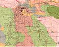
Grass Valley geologic map, and the location of the North Star, Empire, and Maryland mines
-
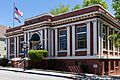
The public library, named for Josiah Royce


See also
 In Spanish: Grass Valley para niños
