Gray County, Texas facts for kids
Quick facts for kids
Gray County
|
|
|---|---|

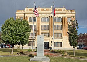
The Gray County Courthouse
|
|

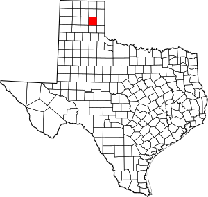
Location within the U.S. state of Texas
|
|
 Texas's location within the U.S. |
|
| Country | |
| State | |
| Founded | 1902 |
| Named for | Peter W. Gray |
| Seat | Pampa |
| Largest city | Pampa |
| Area | |
| • Total | 929 sq mi (2,410 km2) |
| • Land | 926 sq mi (2,400 km2) |
| • Water | 3.4 sq mi (9 km2) 0.4% |
| Population
(2020)
|
|
| • Total | 21,227 |
| • Density | 22.849/sq mi (8.822/km2) |
| Time zone | UTC−6 (Central) |
| • Summer (DST) | UTC−5 (CDT) |
| Congressional district | 13th |
Gray County is a county located in the U.S. state of Texas. As of the 2020 census, its population was 21,227. The county seat is Pampa. The county was created in 1876 and later organized in 1902. is named for Peter W. Gray, a Confederate lawyer and soldier in the American Civil War.
Gray County comprises the Pampa, TX micropolitan statistical area.
Gray County was the center of the White Deer Lands Management Company, which ceased operations in 1957. The history of the company is the theme of the White Deer Land Museum in Pampa, but company archives are at the Panhandle-Plains Historical Museum in Canyon. Timothy Dwight Hobart, the White Deer land agent from 1903 to 1924, was elected mayor of Pampa in 1927.
The Clinton-Oklahoma-Western Railway Company of Texas served Gray County with service to Hemphill County at the Oklahoma border. Another line then connected eastward to Clinton, Oklahoma. An 11-mile extension of the COW-T ran from rural Heaton to the former oil camp of Coltexo in Gray County. Originally a Frank Kell property, the COW-T was acquired in 1928 by the Atchison, Topeka and Santa Fe Railway, which then leased it in 1931 to the Panhandle and Santa Fe Railway (one of the Santa Fe's operating entities within the state of Texas).
Contents
Geography
According to the U.S. Census Bureau, the county has a total area of 929 square miles (2,410 km2), of which 926 square miles (2,400 km2) is land and 3.4 square miles (8.8 km2) (0.4%) is water.
Major highways
 Interstate 40
 U.S. Highway 60
 State Highway 70
 State Highway 152
 State Highway 273
Adjacent counties
- Roberts County (north)
- Wheeler County (east)
- Donley County (south)
- Carson County (west)
- Hemphill County (northeast)
- Hutchinson County (northwest)
- Collingsworth County (southeast)
National protected area
Demographics
| Historical population | |||
|---|---|---|---|
| Census | Pop. | %± | |
| 1880 | 56 | — | |
| 1890 | 203 | 262.5% | |
| 1900 | 480 | 136.5% | |
| 1910 | 3,405 | 609.4% | |
| 1920 | 4,663 | 36.9% | |
| 1930 | 22,090 | 373.7% | |
| 1940 | 23,911 | 8.2% | |
| 1950 | 24,728 | 3.4% | |
| 1960 | 31,535 | 27.5% | |
| 1970 | 26,949 | −14.5% | |
| 1980 | 26,386 | −2.1% | |
| 1990 | 23,967 | −9.2% | |
| 2000 | 22,744 | −5.1% | |
| 2010 | 22,535 | −0.9% | |
| 2020 | 21,227 | −5.8% | |
| U.S. Decennial Census 1850–2010 2010 2020 |
|||
2020 census
| Race / Ethnicity | Pop 2010 | Pop 2020 | % 2010 | % 2020 |
|---|---|---|---|---|
| White alone (NH) | 15,564 | 13,025 | 69.07% | 61.36% |
| Black or African American alone (NH) | 1,055 | 835 | 4.68% | 3.93% |
| Native American or Alaska Native alone (NH) | 152 | 141 | 0.67% | 0.66% |
| Asian alone (NH) | 83 | 127 | 0.37% | 0.60% |
| Pacific Islander alone (NH) | 1 | 0 | 0.00% | 0.00% |
| Some Other Race alone (NH) | 11 | 37 | 0.05% | 0.17% |
| Mixed Race/Multi-Racial (NH) | 304 | 715 | 1.35% | 3.37% |
| Hispanic or Latino (any race) | 5,365 | 6,347 | 23.81% | 29.90% |
| Total | 22,535 | 21,227 | 100.00% | 100.00% |
Note: the US Census treats Hispanic/Latino as an ethnic category. This table excludes Latinos from the racial categories and assigns them to a separate category. Hispanics/Latinos can be of any race.
Communities
City
- Pampa (county seat)
Town
Unincorporated community
Notable people
- Phil Cates, state representative from 1971 to 1979, was born in Pampa in 1947.
- Tom Mechler, state Republican Party chairman since 2015, is a former Gray County Republican chairman.
- Kae T. Patrick, a native of Gray County, served in the Texas House of Representatives from San Antonio from 1981 to 1988.
See also
 In Spanish: Condado de Gray (Texas) para niños

