
Great Basin facts for kids

The Great Basin is a desert area in the western United States of America, part of the Basin and Range Province. It is very dry and very large, occupying most of the state of Nevada and extending into California, Idaho, Oregon, Utah, and a small part of Wyoming. In all, is about 200,000 square miles (520,000 square kilometers) in size. It is an 'endorheic' basin, which means that there is no outlet to the ocean. The Great Basin runs from the highest land in the Sierras and Rockies in the west, down to lowland deserts in the east.
The Great Basin's longest and largest river is the Bear River of 350 mi (560 km), and the largest single watershed is the Humboldt River drainage of roughly 17,000 sq mi (44,000 km2).
Most Great Basin precipitation is snow. The water that neither evaporates nor is taken for human use will sink into groundwater aquifers. Evaporation occurs from geographic sinks.
Lake Tahoe, North America's largest alpine lake, is part of the Great Basin's central Lahontan subregion.
Images for kids
-
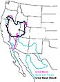
The hydrographic Great Basin (magenta outline), distinguished from the Great Basin Desert (black), and the Basin and Range Geological Province (teal).
-
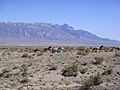
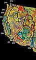
The Tule Valley watershed and the House Range (Notch Peak) are part of the Great Basin's Great Salt Lake hydrologic unit
-
Ecoregions as currently delineated by the Environmental Protection Agency and World Wildlife Fund
-
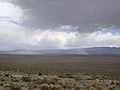
Great Basin snowstorm in the Snake Valley of Utah and Nevada
-
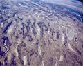
Basin and Range topography as seen from the air
-
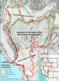
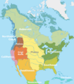
Map showing the Great Basin physiographic section (shown as 22a)
-
Native American tribes that inhabited the Great Basin were divided between the "Great Basin" and, in the Colorado desert region, the "California" tribal classifications.
-
Wah Wah Valley, Utah, thunderstorm


See also
 In Spanish: Gran Cuenca para niños
