Green Township, New Jersey facts for kids
Quick facts for kids
Green Township, New Jersey
|
|
|---|---|
|
Township
|
|
| Township of Green | |
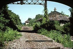
Greendell Station
|
|
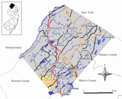
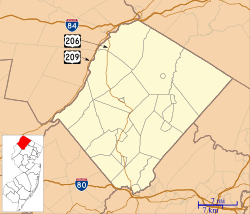
Map of Green Township in Sussex County. Inset: Location of Sussex County highlighted in the State of New Jersey.
|
|
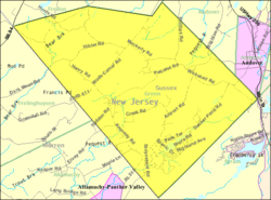
Census Bureau map of Green Township, New Jersey
|
|
| Country | |
| State | |
| County | |
| Incorporated | December 27, 1824 |
| Named for | Ephraim Green |
| Government | |
| • Type | Township |
| • Body | Township Committee |
| Area | |
| • Total | 16.30 sq mi (42.21 km2) |
| • Land | 16.03 sq mi (41.53 km2) |
| • Water | 0.27 sq mi (0.69 km2) 1.63% |
| Area rank | 168th of 565 in state 15th of 24 in county |
| Elevation | 597 ft (182 m) |
| Population | |
| • Total | 3,601 |
| • Estimate
(2019)
|
3,471 |
| • Rank | 429th of 566 in state 15th of 24 in county |
| • Density | 225.3/sq mi (87.0/km2) |
| • Density rank | 496th of 566 in state 15th of 24 in county |
| Time zone | UTC−05:00 (Eastern (EST)) |
| • Summer (DST) | UTC−04:00 (Eastern (EDT)) |
| ZIP Code |
07821 - Andover, New Jersey
|
| Area code(s) | 908 |
| FIPS code | 3403727420 |
| GNIS feature ID | 0882264 |
Green Township is a township in Sussex County, New Jersey, United States. As of the 2010 United States Census, the township's population was 3,601, reflecting an increase of 381 (+11.8%) from the 3,220 counted in the 2000 Census, which had in turn increased by 511 (+18.9%) from the 2,709 counted in the 1990 Census.
Contents
History
On November 20, 1824, the southern portion of Sussex County was set off to create Warren County. The northern portions of both Hardwick and Independence Townships, remained in Sussex County and were incorporated as Green Township by an act of the New Jersey Legislature on December 27, 1824.
In 1829, part of Green Township were transferred to Byram Township, and in 1853 Green Township was expanded to include a section of the old Newtown Township. On February 24, 1904, Fredon Township was incorporated from a portion of the township. In 1881, the area was listed as 19.65 square miles (50.9 km2); and today Green encompasses 16.5 square miles (43 km2). The township was named after Ephraim Green, who settled near Greendell in 1770. Many sections of Green retain their own unique identity, such as Tranquility, Huntsville, Greendell and Yellow Frame.
Tranquility was originally known as Kennedytown, named for Amos Kennedy who settled here. When the location for the Tranquility Methodist Church was being chosen, a disagreement arose over erecting it in Allamuchy Township or Kennedytown. A compromise was affected, with the church being erected halfway between the two points. To memorialize the agreement, the church was named Tranquility. Later, Kennedytown took the church's name as its own.
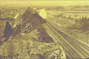
In 1911, the Lackawanna Cut-off rail line opened through Green Township, with a stop at Greendell Station. The Cut-Off was part of the Delaware, Lackawanna & Western Railroad's mainline from Hoboken to Buffalo. The line was abandoned in 1980 and the tracks were removed four years later. New Jersey Transit is considering reactivating passenger service on the line extending to Scranton, Pennsylvania, with a proposed maintenance-of-way facility at Greendell that would incorporate the surviving station building.
In August 2006, a documentary titled The History of Green Township was produced by Kelsey Falkowski. The video includes historical landmarks, interviews with lifelong citizens of Green Township, and leads up to the contemporary view of the township. Copies can be obtained through the Green Township Historical Society.
Geography
According to the United States Census Bureau, Green township had a total area of 16.256 square miles (42.104 km2), including 15.983 square miles (41.397 km2) of land and 0.273 square miles (0.707 km2) of water (1.68%).
Unincorporated communities, localities and place names located partially or completely within the township include Brighton Lakes, Buckmire Pond, Greendell, Huntsburg, Huntsville, Lincoln, Tranquility, Whitehall and Yellow Frame.
Demographics
| Historical population | |||
|---|---|---|---|
| Census | Pop. | %± | |
| 1830 | 801 | — | |
| 1840 | 777 | −3.0% | |
| 1850 | 823 | 5.9% | |
| 1860 | 1,023 | 24.3% | |
| 1870 | 868 | −15.2% | |
| 1880 | 727 | −16.2% | |
| 1890 | 636 | −12.5% | |
| 1900 | 627 | −1.4% | |
| 1910 | 888 | 41.6% | |
| 1920 | 454 | −48.9% | |
| 1930 | 539 | 18.7% | |
| 1940 | 540 | 0.2% | |
| 1950 | 596 | 10.4% | |
| 1960 | 854 | 43.3% | |
| 1970 | 1,343 | 57.3% | |
| 1980 | 2,450 | 82.4% | |
| 1990 | 2,709 | 10.6% | |
| 2000 | 3,220 | 18.9% | |
| 2010 | 3,601 | 11.8% | |
| 2019 (est.) | 3,471 | −3.6% | |
| Population sources: 1830-1920 1840 1850-1870 1850 1870 1880-1890 1890-1910 1910-1930 1930-1990 2000 2010 * = Lost territory in previous decade. |
|||
Census 2010
As of the census of 2010, there were 3,601 people, 1,181 households, and 997 families residing in the township. The population density was 225.3 per square mile (87.0/km2). There were 1,251 housing units at an average density of 78.3 per square mile (30.2/km2)*. The racial makeup of the township was 94.78% (3,413) White, 1.25% (45) Black or African American, 0.03% (1) Native American, 1.72% (62) Asian, 0.00% (0) Pacific Islander, 0.78% (28) from other races, and 1.44% (52) from two or more races. [[Hispanic (U.S. Census)|Hispanic or Latino of any race were 4.80% (173) of the population.
There were 1,181 households out of which 43.0% had children under the age of 18 living with them, 76.0% were married couples living together, 5.2% had a female householder with no husband present, and 15.6% were non-families. 11.2% of all households were made up of individuals, and 4.1% had someone living alone who was 65 years of age or older. The average household size was 3.04 and the average family size was 3.31.
In the township, the population was spread out with 28.4% under the age of 18, 6.3% from 18 to 24, 21.5% from 25 to 44, 33.0% from 45 to 64, and 10.8% who were 65 years of age or older. The median age was 41.9 years. For every 100 females there were 100.7 males. For every 100 females ages 18 and old there were 98.9 males.
The Census Bureau's 2006-2010 American Community Survey showed that (in 2010 inflation-adjusted dollars) median household income was $103,693 (with a margin of error of +/- $15,229) and the median family income was $113,971 (+/- $20,140). Males had a median income of $85,591 (+/- $9,018) versus $50,583 (+/- $7,305) for females. The per capita income for the borough was $37,546 (+/- $3,396). About 1.3% of families and 2.3% of the population were below the poverty line, including 1.8% of those under age 18 and none of those age 65 or over.
Census 2000
As of the 2000 United States Census there were 3,220 people, 1,046 households, and 890 families residing in the township. The population density was 199.0 people per square mile (76.8/km2). There were 1,069 housing units at an average density of 66.1 per square mile (25.5/km2). The racial makeup of the township was 96.49% White, 0.93% African American, 0.03% Native American, 0.96% Asian, 0.28% from other races, and 1.30% from two or more races. Hispanic or Latino of any race were 3.20% of the population.
There were 1,046 households, out of which 45.5% had children under the age of 18 living with them, 78.9% were married couples living together, 3.8% had a female householder with no husband present, and 14.9% were non-families. 11.0% of all households were made up of individuals, and 3.3% had someone living alone who was 65 years of age or older. The average household size was 3.07 and the average family size was 3.34.
In the township the population was spread out, with 30.8% under the age of 18, 5.0% from 18 to 24, 31.7% from 25 to 44, 26.5% from 45 to 64, and 6.0% who were 65 years of age or older. The median age was 36 years. For every 100 females, there were 104.7 males. For every 100 females age 18 and over, there were 97.3 males.
The median income for a household in the township was $84,847, and the median income for a family was $89,788. Males had a median income of $61,576 versus $33,393 for females. The per capita income for the township was $34,127. About 0.9% of families and 1.6% of the population were below the poverty line, including 1.7% of those under age 18 and 4.5% of those age 65 or over.
Transportation
As of May 2010[update], the township had a total of 49.28 miles (79.31 km) of roadways, of which 33.44 miles (53.82 km) were maintained by the municipality and 15.84 miles (25.49 km) by Sussex County.
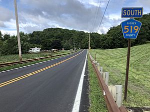
No Interstate, U.S. or state highways directly serve Green Township. The most prominent roadways are county routes, including County Route 517 and County Route 519.
Education
Students in public school for kindergarten through eighth grade attend the Green Township School District at Green Hills School. As of the 2017–18 school year, the district, comprised of one school, had an enrollment of 436 students and 38.3 classroom teachers (on an FTE basis), for a student–teacher ratio of 11.4:1. Green Hills has participated in New Jersey's Interdistrict Public School Choice Program beginning with the 2013–2014 school year, under which students from outside Green Township may attend Green Hills as long as they live within a radius of 20 miles (32 km).
Public school students in ninth through twelfth grades attend Newton High School in Newton, together with students from Andover Borough and Andover Township, as part of a sending/receiving relationship with the Newton Public School District. As of the 2017–18 school year, the high school had an enrollment of 719 students and 67.5 classroom teachers (on an FTE basis), for a student–teacher ratio of 10.6:1.
Notable people
People who were born in, residents of, or otherwise closely associated with Green Township include:
- Lucy Page Mercer Rutherfurd (1891–1948), interred in Green Township, she is considered by historians to have been a mistress of United States President Franklin Delano Roosevelt and was with him on the day he died in 1945.
See also
 In Spanish: Municipio de Green (Nueva Jersey) para niños


