
Greenbelt, Maryland facts for kids
Quick facts for kids
Greenbelt, Maryland
|
|||
|---|---|---|---|
.jpg)
in March 2011. The city's commercial center typifies the Art Deco style used during the original construction of Greenbelt.
|
|||
|
|||

Location in Prince George's County and Maryland
|
|||

Greenbelt, Maryland
Location in Maryland
|
|||
| Country | |||
| State | |||
| County | |||
| Incorporated | June 1, 1937 | ||
| Area | |||
| • Total | 6.29 sq mi (16.29 km2) | ||
| • Land | 6.24 sq mi (16.15 km2) | ||
| • Water | 0.06 sq mi (0.14 km2) 0.99% | ||
| Elevation | 157 ft (48 m) | ||
| Population
(2020)
|
|||
| • Total | 24,921 | ||
| • Density | 3,996.95/sq mi (1,543.35/km2) | ||
| Time zone | UTC−05:00 (Eastern) | ||
| • Summer (DST) | UTC−04:00 (Eastern) | ||
| ZIP Codes |
20770, 20771, 20768
|
||
| Area codes |
|
||
| FIPS code | 24-34775 | ||
| GNIS feature ID | 2390596 | ||


Greenbelt is a city in Prince George's County, Maryland, United States, and a suburb of Washington, D.C. Per the 2020 census, the population was 24,921.
Greenbelt is notable for being the first and the largest of the three experimental and controversial New Deal Greenbelt Towns: Greenhills, Ohio and Greendale, Wisconsin being the others. Thus, it was planned and built by the Federal government. The cooperative community was conceived in 1935 by Undersecretary of Agriculture Rexford Guy Tugwell, whose perceived collectivist ideology attracted opposition to the Greenbelt Towns project throughout its short duration. The project came into legal existence in the spring of 1935. On April 8, 1935, Congress passed the Emergency Relief Appropriation Act of 1935. Under the authority granted to him by this legislation, President Franklin D. Roosevelt issued an executive order, on May 1, 1935, establishing the United States Resettlement Administration (RA/RRA).
Originally referred to as Maryland Special Project No. 1, the project was officially given the name Greenbelt when the Division of Suburban Resettlement of the Resettlement Administration began construction on January 13, 1936, approximately eight miles north of Washington. The complete Greenbelt plans were reviewed at the White House by President Roosevelt and First Lady Eleanor Roosevelt on April 30, 1936. The first tenants, after being selected through a stringent and restrictive application process, moved into the town, which consisted of structures built in the Art Deco, Streamline Moderne, and Bauhaus architectural styles, on September 30, 1937.
Greenbelt is credited as a historic milestone in urban development, which includes its role as having served as the initial model for the privately constructed suburban Washington, D.C. planned cities of Reston, Virginia and Columbia, Maryland.
The original federally-built core of the city, known locally as Old Greenbelt, was recognized as the Greenbelt Historic District by the Maryland Historical Trust, and is listed on the National Register of Historic Places as a National Historic Landmark District.
Greenbelt's population, which includes residents of private sector dwellings that were constructed over several decades subsequent to the federal government's ownership of the city, was recorded as 23,068 in the 2010 U.S. Census.
Contents
Geography


Greenbelt is located at 39°0′2″N 76°53′18″W / 39.00056°N 76.88833°W (39.000460, -76.888325).

According to the United States Census Bureau, the city has a total area of 6.34 square miles (16.42 km2), of which, 6.28 square miles (16.27 km2) is land and 0.06 square miles (0.16 km2) is water. Greenbelt's ZIP codes are 20768, 20770, and 20771.
The National Aeronautics and Space Administration's Goddard Space Flight Center is located in Greenbelt, as is Greenbelt Park, a unit of the National Park System.
Transportation
Two major highways pass through and have interchanges in Greenbelt: the Capital Beltway (I-95/I-495) and the National Park Service's Baltimore-Washington Parkway (Route 295). Greenbelt Road is a portion of State Highway 193, which connects several suburban towns. Kenilworth Avenue (Route 201) traverses Greenbelt in a North-South direction.
Washington Metro rapid transit rail service from Washington, D.C., serves Greenbelt Metro Station, the northern terminus of the system's Green Line. Commuter rail service to the same station is provided by MARC's Camden Line between Washington's Union Station and Camden Station in Baltimore, Maryland, using the original 1835 Baltimore and Ohio Railroad (B&O) track route between Washington and Baltimore, now part of the CSX System.
Bordering areas
- Beltsville Agricultural Research Center
- Berwyn Heights
- College Park
- Goddard
- Lanham
- New Carrollton
- Glenn Dale
History

Old Greenbelt was settled in 1937 as a public cooperative community in the New Deal Era. The concept was at the same time both eminently practical and idealistically utopian: the federal government would foster an "ideal" self-sufficient cooperative community that would also ease the pressing housing shortage near the nation's capital. Construction of the new town would also create jobs and thus help stimulate the national economic recovery following the Great Depression.
Greenbelt, which provided affordable housing for federal government workers, was one of three "green" towns planned in 1935 by Rexford Guy Tugwell, head of the United States Resettlement Administration, under authority of the Emergency Relief Appropriation Act. Working alongside Tugwell was Charles W. Yost. The two other green towns are Greendale, Wisconsin (near Milwaukee) and Greenhills, Ohio (near Cincinnati). A fourth green town, Roosevelt, New Jersey (originally called Homestead), was planned but was not fully developed on the same large scale as Greenbelt.
Eleanor Roosevelt, wife of President Franklin D. Roosevelt, helped Tugwell lay out the Maryland town on a site that had formerly consisted largely of tobacco fields. She was also heavily involved in the first cooperative community designed by the federal government in the New Deal Era, Arthurdale, West Virginia, which sought to improve the lives of impoverished laborers by enabling them to create a self-sufficient, and relatively prosperous, cooperative community. Cooperatives in Greenbelt include the Greenbelt News Review, Greenbelt Consumers Coop grocery store, the New Deal Cafe, and the cooperative forming the downtown core of original housing, Greenbelt Homes Incorporated (GHI).
The architectural planning of Greenbelt was innovative, but no less so than the social engineering involved in this federal government project. Applicants for residency were interviewed and screened based on income and occupation, and willingness to become involved in community activities. African-Americans were initially excluded, but were later included by the Greenbelt Committee for Fair Housing founded in 1963, and came to number 41% of residents according to the 2000 census. The same census data also indicates that African-Americans are isolated in certain parts within the town and the percentage of African-Americans within the historic area is often between 0% and 5% on most blocks.
Much of the community is now located within the Greenbelt Historic District; listed on the National Register of Historic Places in 1980.
Greenbelt was the subject of the 1939 documentary film The City.
Demographics
| Historical population | |||
|---|---|---|---|
| Census | Pop. | %± | |
| 1940 | 2,831 | — | |
| 1950 | 7,074 | 149.9% | |
| 1960 | 7,479 | 5.7% | |
| 1970 | 18,199 | 143.3% | |
| 1980 | 17,332 | −4.8% | |
| 1990 | 21,096 | 21.7% | |
| 2000 | 21,456 | 1.7% | |
| 2010 | 23,068 | 7.5% | |
| 2020 | 24,921 | 8.0% | |
| U.S. Decennial Census 2010 2020 |
|||
2020 census
| Race / Ethnicity | Pop 2010 | Pop 2020 | % 2010 | % 2020 |
|---|---|---|---|---|
| White alone (NH) | 5,974 | 5,176 | 25.90% | 20.77% |
| Black or African American alone (NH) | 10,852 | 11,897 | 47.04% | 47.74% |
| Native American or Alaska Native alone (NH) | 43 | 47 | 0.19% | 0.19% |
| Asian alone (NH) | 2,238 | 2,323 | 9.70% | 9.32% |
| Pacific Islander alone (NH) | 18 | 10 | 0.08% | 0.04% |
| Some Other Race alone (NH) | 61 | 192 | 0.26% | 0.77% |
| Mixed Race/Multi-Racial (NH) | 581 | 996 | 2.52% | 4.00% |
| Hispanic or Latino (any race) | 3,301 | 4,280 | 14.31% | 17.17% |
| Total | 23,068 | 24,921 | 100.00% | 100.00% |
Note: the US Census treats Hispanic/Latino as an ethnic category. This table excludes Latinos from the racial categories and assigns them to a separate category. Hispanics/Latinos can be of any race.
2010 census
During the census of 2010, there were 23,068 people, 9,747 households, and 5,367 families residing in the city. The population density was 3,673.2 inhabitants per square mile (1,418.2/km2). There were 10,433 housing units at an average density of 1,661.3 per square mile (641.4/km2). The racial makeup of the city was 30.1% White, 47.8% African American, 0.3% Native American, 9.7% Asian, 0.1% Pacific Islander, 8.6% from other races, and 3.3% from two or more races. Hispanic or Latino of any race were 14.3% of the population.
There were 9,747 households, of which 31.0% had children under the age of 18 living with them, 30.7% were married couples living together, 18.3% had a female householder with no husband present, 6.0% had a male householder with no wife present, and 44.9% were non-families. 36.1% of all households were made up of individuals, and 7.3% had someone living alone who was 65 years of age or older. The average household size was 2.37 and the average family size was 3.12.
The median age in the city was 33.7 years. 22.8% of residents were under the age of 18; 10.1% were between the ages of 18 and 24; 34.4% were from 25 to 44; 25.3% were from 45 to 64, and 7.5% were 65 years of age or older. The gender makeup of the city was 46.7% male and 53.3% female.
Greenbelt Historic District
Designated as a National Historic Landmark in 1997, the Greenbelt Historic District contains Roosevelt Center and many buildings in the Art Deco style. The Historic District has retained several of the original businesses in Roosevelt Center including the Greenbelt Co-Op Supermarket and Pharmacy and the Old Greenbelt Theatre, while also adding new businesses such as the New Deal Cafe.
Gallery
-
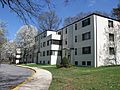
Apartments in Greenbelt
-
Extensive pedestrian paths connect residences, in this case feeding into a tunnel beneath the primary collector roadway
-
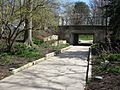
A grade-separated pedestrian path / roadway crossing, inspired by such configurations in Radburn, New Jersey
-

Albert S. Buddy Attick Lake Park. The artificial lake replaces the open parkland of the Radburn plan
-
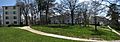
Southway, a road on the southern portion of Old Greenbelt
-
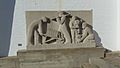
One of several panels by sculptor Lenore Thomas Straus, installed at the Greenbelt Community Center


Economy
Top employers
According to Greenbelt's 2018 Comprehensive Annual Financial Report, the top employers in the city were:
| Number | Employer | Employees |
|---|---|---|
| 1 | City of Greenbelt | 463 |
| 2 | Bozzuto Group | 460 |
| 3 | Eleanor Roosevelt High School | 350 |
| 4 | Burlington Stores, Inc. | 229 |
| 5 | Springhill Lake Hotel Partners, LLC | 148 |
| 6 | Paradyme Management Inc. | 134 |
| 7 | Martin's | 130 |
| 8 | Giant Food of Maryland, LLC | 126 |
| 9 | Greenbelt Middle School | 123 |
| 10 | ATA Aerospace, LLC | 116 |
Source: data are taken from employers who made information available, and the list does not include the US Federal Government (NASA's Goddard Space Flight Center).
Education

Greenbelt is served by Prince George's County Public Schools (PGCPS).
There are three public elementary schools serving sections of Greenbelt:
- Greenbelt Elementary School (Greenbelt),
- Magnolia Elementary School (unincorporated Prince George's County, Lanham address), and
- Springhill Lake Elementary School (Greenbelt).
All of Greenbelt is served by Greenbelt Middle School (Greenbelt), which includes a Talented and Gifted magnet program.
All of Greenbelt is served by Eleanor Roosevelt High School (Greenbelt), a school which includes a Science and Technology magnet program and an AP Capstone program.
There is a public magnet school within the City:
- Dora Kennedy French Immersion School (Greenbelt), which serves K through 8th grade students. The school uses language immersion with instruction in the French language.
There are no private schools within the City of Greenbelt. There is a Catholic school in nearby Lanham CDP, Academy of Saint Matthias the Apostle.
History of schools
The Lanham Act was used to build North End Elementary School. The original Greenbelt High School building (later used for Greenbelt Junior High, Greenbelt Middle, and currently Dora Kennedy French Immersion School) opened in c. 1937. Originally, the Federal Works Agency controlled North End Elementary School, Greenbelt High School, and the Center School. High Point High School, in Beltsville, opened in fall 1954, and began serving students from Greenbelt. The former Greenbelt High School then became Greenbelt Junior High School. The county bought Center School for $260,000, after the federal government renovated it in July 1958. The county also bought Greenbelt Junior High and North End Elementary. Roosevelt High was scheduled to open in fall 1976. The new Greenbelt Middle School opened on August 20, 2012.
Public libraries
Greenbelt is served by the Greenbelt Branch of the Prince George's County Memorial Library System.
Transportation
_from_the_overpass_for_Cherrywood_Lane_in_Greenbelt,_Prince_George%27s_County,_Maryland.jpg)
Roads and highways
Two major highways pass through and have interchanges in Greenbelt: the Capital Beltway (I-95/I-495) and the National Park Service's owned and maintained portion of the Baltimore–Washington Parkway (unsigned MD 295). The Greenbelt portion of the Baltimore–Washington Parkway (B–W Parkway) is part of the parkway's 19-mile section which was listed on the National Register of Historic Places in 1991.
Additionally, Greenbelt Road is part of state highway MD 193, which connects several suburban communities in both Prince George's and Montgomery counties. Kenilworth Avenue (MD 201) traverses Greenbelt in a north–south direction, running parallel to the B–W Parkway, providing an alternate travel route into Washington, D.C., from Greenbelt. The southernmost Maryland portion of Kenilworth Avenue forms a major interchange with both the B–W Parkway and US 50 near the Maryland–D.C. line, and continues into Washington, as the Kenilworth Avenue Freeway (DC 295).
Public transportation

Washington Metro's rapid transit rail system serves Washington, D.C., and neighboring communities in Maryland and Northern Virginia, by operating 91 Metro stations, which includes the Greenbelt station, the northern terminus of Metro's Green Line. Commuter rail service to the station is provided by MARC Train's Camden Line, which connects the District of Columbia's Washington Union Station with Camden Station in Baltimore. The Camden Line provides service by utilizing the original 1835 Baltimore and Ohio Railroad (B&O) track route between Washington and Baltimore, now part of the CSX System.
Also available at the station, is a weekday express Metrobus service, the Greenbelt–BWI Thurgood Marshall Airport Express Line (commonly shortened to the Greenbelt–BWI Airport Line), designated route B30, to Baltimore/Washington International Thurgood Marshall Airport (BWI), a mode of transportation to and from the airport for airline passengers, in addition to allowing for connections to Baltimore's regional transit services.
Metrobus, Prince George's County's THE BUS (routes 11 and 15X), and the University of Maryland's Shuttle-UM (route 143; campus ID or pass required) each have bus routes which serve the city of Greenbelt. Through a city–university partnership that began in 2017, Greenbelt residents are permitted to unlimited travel on Shuttle UM, with the purchase of a $10 annual pass.
Notable people
- Abraham Chasanow
- Isaiah Prince, offensive lineman for the Ohio State University and the Cincinnati Bengals
- Phyllis Richman, restaurant critic for The Washington Post from 1976 to 2000
- Dorothy Sucher, author
- Steve Rochinski, jazz guitarist, recording artist, composer/arranger, educator, and author — childhood home from 1955 to 1960
- Rosa Salazar, actor
Images for kids
-

Scenic entry to the Nation's Capital: The Baltimore–Washington Parkway
-
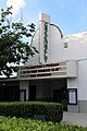
The Old Greenbelt Theatre in 2020, with a marquee referencing the George Floyd protests. The theatre opened on September 21, 1938, screening the film Little Miss Broadway with Shirley Temple.

See also
 In Spanish: Greenbelt (Maryland) para niños
