
Greenbelt (Ottawa) facts for kids
Quick facts for kids Greenbelt (Ottawa) |
|
|---|---|
 |
|

Map of Ottawa showing the Greenbelt surrounding the urban core
|
|
| Location | Eastern Ontario, Canada |
| Nearest city | Ottawa |
| Area | 203.5 km2 (78.6 sq mi) |
| Established | 1956 |
| Governing body | National Capital Commission |
The Greenbelt (French: Ceinture de verdure) is a 203.5-square-kilometre (78.6 sq mi) protected green belt traversing Ottawa, Ontario, Canada. It includes green space, forests, farms, and wetlands from Shirleys Bay in the west and to Green's Creek in the east. The National Capital Commission (NCC) owns and manages 149.5 square kilometres (57.7 sq mi), and the rest is held by other federal government departments and private interests. Real estate development within the Greenbelt is strictly controlled.
History
The Greenbelt was proposed by Jacques Gréber in 1950 as part of his master plan for Ottawa, and the federal government started expropriating land in 1956. Its original purpose included the prevention of urban sprawl (which was threatening the rural areas surrounding the city), as well as to provide open space for the future development of farms, natural areas and government campuses. At the time, the greenbelt was "intended to circumscribe an area large enough for the accommodation of some 500,000 persons. The inner limit was chosen by considering what area could be economically provided with municipal services."
Wildlife

The Greenbelt is home to a variety of wildlife:
- Mammals: bat, bear, beaver, coyote, cottontail rabbit, fisher, muskrat, porcupine, raccoon, red fox, red squirrel, snowshoe hare, skunk, white-tailed deer, rarely moose
- Birds: barred owl, screech owl, great grey owl, Canada goose, sandhill crane, great blue heron, red-tailed hawk, American kestrel, spruce grouse, woodcock, blue jay, chickadee
- Insects: walking stick, praying mantis, butterflies
- Reptiles/Amphibians: common garter snake, painted turtle, snapping turtle
Places of interest

Places of interest within the Greenbelt are from east to west:
- Green's Creek Conservation Area – a nature reserve of a small tributary of the Ottawa River, cutting through a lush clay valley. 45°28′00″N 75°34′35″W / 45.46667°N 75.57639°W
- Hornets Nest soccer fields – 11 soccer fields and an air-supported dome for indoor soccer. 45°26′35″N 75°34′35″W / 45.44306°N 75.57639°W
- Pine View Golf Course – 36-hole public golf course 45°25′50″N 75°35′50″W / 45.43056°N 75.59722°W
- Mer Bleue Conservation Area – 33 km² sphagnum peat bog. There are some 20 km of walking trails, including a 1.2 km boardwalk, through a remarkable boreal-like ecosystem normally not found this far south. Stunted black spruce, tamarack, together with bog rosemary, blueberry, and cottongrass, are some of the unusual species that have adapted to the acidic waters of the bog. The Mer Bleue bog (French for Blue Sea) got its name from the autumn morning fogs that make it appear as a blue sea. 45°24′00″N 75°30′00″W / 45.40000°N 75.50000°W
- Pine Grove Forest – 12 km² of mixed-use forest for hiking, wildlife reserve, and forestry. 45°21′30″N 75°36′00″W / 45.35833°N 75.60000°W
- Conroy Pit – a 1.1 km² site on a former sand/gravel pit off Conroy Road near Hunt Club Road, now used primarily as an off-leash dog park and for tobogganing in the winter. It has several kilometres of urban forest trails and wide open areas. The north end of the pit features a large toboggan hill. 45°21′30″N 75°37′30″W / 45.35833°N 75.62500°W
- Hylands Golf Club – 36-hole public golf course 45°19′00″N 75°38′35″W / 45.31667°N 75.64306°W
- Macdonald-Cartier International Airport – Ottawa's main airport for domestic, international, and general aviation. 45°19′30″N 75°40′00″W / 45.32500°N 75.66667°W
- Agriculture Canada Research Farms – 17 km² site for research in animal disease prevention and treatment. 45°19′08″N 75°45′12″W / 45.31889°N 75.75333°W
- The Log Farm – a restored homestead from 1857, with guided tours. 45°17′59″N 75°47′50″W / 45.29972°N 75.79722°W
- Bruce Pit – a second former sand/gravel pit off Cedarview Road between Hunt Club Road and Baseline Road. It is now used as an off-leash dog park, and has a cross-country trail system and a toboggan hill. 45°19′30″N 75°48′00″W / 45.32500°N 75.80000°W
- Lime Kiln (Trail) – Trail to remains of 19th-century Flood industrial lime kiln.45°17′13.7″N 75°48′48.8″W / 45.287139°N 75.813556°W
- Stony Swamp Conservation Area – 20 km² of provincially significant wetland. It is also the largest forested area within the Greenbelt and is popular for hiking and outdoor recreation. It is also the study area for the Macoun Field Club.45°18′00″N 75°50′20″W / 45.30000°N 75.83889°W
- Wesley Clover Parks (formerly the Nepean National Equestrian Park 45°20′22″N 75°51′10″W / 45.33944°N 75.85278°W and the Ottawa Municipal Campground 45°19′50″N 75°52′00″W / 45.33056°N 75.86667°W) - an equestrian facility and public campground with 127 serviced sites
- The 19th Tee Driving Range – golf driving range and 18 hole mini-putt park. 45°20′43″N 75°52′38″W / 45.34528°N 75.87722°W
- Connaught National Army Cadet Summer Training Centre – Military and cadet training centre, also used by private shooting associations. 45°21′40″N 75°54′00″W / 45.36111°N 75.90000°W
- Shirleys Bay – an important wetland on the Ottawa River, home to migratory birds and water fowl. This location is ideally suited for bird watching. 45°23′00″N 75°55′00″W / 45.38333°N 75.91667°W
Images for kids
-
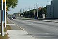
Hunt Club Road (2011)
-
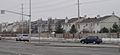
Barrhaven (2006)
-
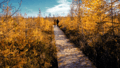
Mer Bleue Bog boardwalk (2019)


.png)
See also
 In Spanish: Greenbelt (Ottawa) para niños
