Greene County, Mississippi facts for kids
Quick facts for kids
Greene County
|
|
|---|---|

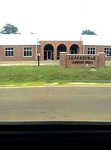
Leaksville Junior High School
|
|

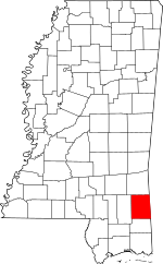
Location within the U.S. state of Mississippi
|
|
 Mississippi's location within the U.S. |
|
| Country | |
| State | |
| Founded | 1811 |
| Named for | Nathanael Greene |
| Seat | Leakesville |
| Largest town | Leakesville |
| Area | |
| • Total | 719 sq mi (1,860 km2) |
| • Land | 713 sq mi (1,850 km2) |
| • Water | 5.9 sq mi (15 km2) 0.8% |
| Population
(2010)
|
|
| • Total | 14,400 |
| • Estimate
(2018)
|
13,586 |
| • Density | 20.03/sq mi (7.73/km2) |
| Time zone | UTC−6 (Central) |
| • Summer (DST) | UTC−5 (CDT) |
| Congressional district | 4th |
Greene County is a county located on the southeast border of the U.S. state of Mississippi. As of the 2010 census, the population was 14,400. Its county seat is Leakesville. Established in 1811, the county was named for General Nathanael Greene of the American Revolutionary War.
Contents
Geography
According to the U.S. Census Bureau, the county has a total area of 719 square miles (1,860 km2), of which 713 square miles (1,850 km2) is land and 5.9 square miles (15 km2) (0.8%) is water.
Major highways
 U.S. Highway 45
 U.S. Highway 98
 Mississippi Highway 42
 Mississippi Highway 57
 Mississippi Highway 63
Adjacent counties
- Wayne County (north)
- Washington County, Alabama (northeast)
- Mobile County, Alabama (southeast)
- George County (south)
- Perry County (west)
National protected area
- De Soto National Forest (part)
Demographics
The rural county had strong declines in population from 1940 to 1960, a period when many African Americans left for the West Coast in the second wave of the Great Migration. The buildup of defense industries in California and other states before and during World War II attracted many migrants for work opportunities.
| Historical population | |||
|---|---|---|---|
| Census | Pop. | %± | |
| 1820 | 1,345 | — | |
| 1830 | 1,854 | 37.8% | |
| 1840 | 1,636 | −11.8% | |
| 1850 | 2,018 | 23.3% | |
| 1860 | 2,232 | 10.6% | |
| 1870 | 2,038 | −8.7% | |
| 1880 | 3,194 | 56.7% | |
| 1890 | 3,906 | 22.3% | |
| 1900 | 6,795 | 74.0% | |
| 1910 | 6,050 | −11.0% | |
| 1920 | 10,430 | 72.4% | |
| 1930 | 10,644 | 2.1% | |
| 1940 | 9,512 | −10.6% | |
| 1950 | 8,215 | −13.6% | |
| 1960 | 8,366 | 1.8% | |
| 1970 | 8,545 | 2.1% | |
| 1980 | 9,827 | 15.0% | |
| 1990 | 10,220 | 4.0% | |
| 2000 | 13,299 | 30.1% | |
| 2010 | 14,400 | 8.3% | |
| 2018 (est.) | 13,586 | −5.7% | |
| U.S. Decennial Census 1790-1960 1900-1990 1990-2000 2010-2013 |
|||
2015
As of 2015[update] the largest self-reported ancestry groups in Greene County, Mississippi are:
- African - 26.18%
- English - 18.9%
- American - 17.6%
- Irish - 7.9%
- German - 4.9%
- Scots-Irish - 4.0%
- Scottish - 3.4%
- French (except Basque) - 1.5%
- Dutch - 1.1%
- Italian - 0.7%
- Welsh - 0.4%
- French-Canadian - 0.1%
- Russian - 0.1%
- Norwegian - 0.1%
The First sheriff of Greene County was Alexander Mclain
2020 census
| Race | Num. | Perc. |
|---|---|---|
| White (non-Hispanic) | 9,809 | 72.5% |
| Black or African American (non-Hispanic) | 3,143 | 23.23% |
| Native American | 60 | 0.44% |
| Asian | 21 | 0.16% |
| Pacific Islander | 3 | 0.02% |
| Other/Mixed | 323 | 2.39% |
| Hispanic or Latino | 171 | 1.26% |
As of the 2020 United States census, there were 13,530 people, 3,925 households, and 2,624 families residing in the county.
Communities
Cities
- Leakesville (county seat)
- McLain
- State Line (partly in Wayne County)
Unincorporated communities
See also
 In Spanish: Condado de Greene (Misisipi) para niños

