
Groton, Massachusetts facts for kids
Quick facts for kids
Groton, Massachusetts
|
||
|---|---|---|

Town Hall
|
||
|
||
| Motto(s):
"All Are Welcome", "Faith, Labor"
|
||

Location in Middlesex County in Massachusetts
|
||
| Country | United States | |
| State | Massachusetts | |
| County | Middlesex | |
| Settled | 1655 | |
| Incorporated | 1655 | |
| Government | ||
| • Type | Open town meeting | |
| Area | ||
| • Total | 33.7 sq mi (87.3 km2) | |
| • Land | 32.8 sq mi (84.9 km2) | |
| • Water | 0.9 sq mi (2.4 km2) | |
| Elevation | 320 ft (98 m) | |
| Population
(2020)
|
||
| • Total | 11,315 | |
| • Density | 335.8/sq mi (129.61/km2) | |
| Time zone | UTC−5 (Eastern) | |
| • Summer (DST) | UTC−4 (Eastern) | |
| ZIP Code |
01450
|
|
| Area codes | 351/978 (978 Exchanges: 448, 449) | |
| FIPS code | 25-27480 | |
| GNIS feature ID | 0619399 | |

Groton is a Town in northwestern Middlesex County, Massachusetts, United States, within the Greater Boston metropolitan area. The population was 11,315 at the 2020 census. It is home to two prep schools: Lawrence Academy at Groton, founded in 1792 and the third-oldest private school in Massachusetts; and Groton School, founded in 1884.
The town was a battlefield in King Philip's War and Queen Anne's War, as England and France competed through their North American colonies from the 17th century well into the 18th century. It was the birthplace of William Prescott, who commanded the colonial forces at the Battle of Bunker Hill during the American Revolution. In postwar years, it had incidents of insurrection during Shays' Rebellion (1786–1787).
Contents
History
The area surrounding modern day Groton has, for thousands of years, been the territory of various cultures of indigenous peoples. They settled along the rivers for fishing and transportation. Historic tribes were Algonquian-speaking Nipmuc and Nashaway Indians.
The Anglo-American Groton started with the trading post of John Tinker, who conducted business there with the Nashaway at the confluence of Nod Brook and the Nashua River. The Nashaway called the area Petapawag, meaning "swampy land." Other pioneers followed the Algonquian trails from Massachusetts Bay, as Tinker had. They found the region productive for fishing and farming.
The town was officially settled and incorporated in 1655, named for Groton in Suffolk, England. Called The Plantation of Groton, it included all of present-day Groton and Ayer, almost all of Pepperell and Shirley, large parts of Dunstable, Littleton, and Tyngsborough plus smaller parts of Harvard and Westford, as well as Nashua, New Hampshire and Hollis, New Hampshire.
During King Philip's War, on March 13, 1676, Indians burned all buildings except for four Groton garrisons. One of those killed was John Nutting, a Selectman at Groton. Survivors fled to Concord and other safe havens, but two years later returned to rebuild. Native Americans attacked the town again during the Raid on Groton in 1694 (King William's War).
In 1704 during Queen Anne's War, a French-Abenaki raid captured three Tarbell children among others, taking them to Kahnewake near Montreal for ransom, which was a thriving business between these opposing colonies. The two younger boys, John and Zachary, were adopted by Mohawk families and became fully assimilated, later marrying into the tribe and becoming chiefs. They were among the founders of Akwesasne, further upriver. Their sister Sarah was ransomed by a French family, converted to Catholicism and joined a Catholic order in Montreal. There are Tarbell-named descendants among Mohawk of Kahnewake in the 21st century.
In 1775, the common in front of the First Parish Church was an assembly area for Minutemen who fought in the Battle of Lexington and Concord.
Geography
According to the United States Census Bureau, Groton has a total area of 33.7 square miles (87.3 km²), of which 32.8 square miles (84.9 km²) is land and 0.9 square miles (2.4 km²) (2.79%) is water. Groton is the largest town in Middlesex County in terms of square mileage. The town is drained by the Nashua River and Squannacook River. The center of the town is dominated mainly by Gibbet Hill, with several other large hills throughout the town.
Groton is served by state routes 40, 111, 119 and 225. It borders the towns of Pepperell, Dunstable, Tyngsborough, Westford, Littleton, Ayer, Shirley and Townsend.
Demographics
| Historical population | ||
|---|---|---|
| Year | Pop. | ±% |
| 1676 | 300 | — |
| 1765 | 1,408 | +369.3% |
| 1776 | 1,639 | +16.4% |
| 1790 | 1,840 | +12.3% |
| 1800 | 1,802 | −2.1% |
| 1810 | 1,886 | +4.7% |
| 1820 | 1,897 | +0.6% |
| 1830 | 1,925 | +1.5% |
| 1840 | 2,139 | +11.1% |
| 1850 | 2,515 | +17.6% |
| 1860 | 3,193 | +27.0% |
| 1870 | 3,584 | +12.2% |
| 1880 | 1,862 | −48.0% |
| 1890 | 2,057 | +10.5% |
| 1900 | 2,052 | −0.2% |
| 1910 | 2,155 | +5.0% |
| 1920 | 2,185 | +1.4% |
| 1930 | 2,434 | +11.4% |
| 1940 | 2,550 | +4.8% |
| 1950 | 2,889 | +13.3% |
| 1960 | 3,904 | +35.1% |
| 1970 | 5,109 | +30.9% |
| 1980 | 6,154 | +20.5% |
| 1990 | 7,511 | +22.1% |
| 2000 | 9,547 | +27.1% |
| 2010 | 10,646 | +11.5% |
| 2020 | 11,315 | +6.3% |
| * = population estimate. Source: United States Census records and Population Estimates Program data. |
||
As of the census of 2000, there were 9,547 people, 3,268 households, and 2,568 families residing in the town. The population density was 291.3 people per square mile (112.5/km2). There were 3,393 housing units at an average density of 103.5 per square mile (40.0/km2). The racial makeup of the town was 97.22% White, 0.35% Black or African American, 0.13% Native American, 0.97% Asian, 0.02% Pacific Islander, 0.27% from other races, and 1.04% from two or more races. Hispanic or Latino of any race were 1.14% of the population.
There were 3,268 households, out of which 46.8% had children under the age of 18 living with them, 70.0% were married couples living together, 6.3% had a female householder with no husband present, and 21.4% were non-families. Of all households 17.1% were made up of individuals, and 5.4% had someone living alone who was 65 years of age or older. The average household size was 2.90 and the average family size was 3.31.
The age distribution of the town's population was 32.6% under the age of 18, 4.2% from 18 to 24, 32.7% from 25 to 44, 23.5% from 45 to 64, and 7.0% who were 65 years of age or older. The median age was 36 years. For every 100 females, there were 98.2 males. For every 100 females age 18 and over, there were 94.5 males.
The median income for a household in the town was $118,041, and the median income for a family was $136,653. Males had a median income of $101,117 versus $60,402 for females. The per capita income for the town was $44,756. About 1.1% of families and 1.8% of the population were below the poverty line, including 1.0% of those under age 18 and none of those age 65 or over.
Points of interest


- Groton Historical Society & Museum
- Gibbet Hill Castle
- Kalliroscope Gallery
- Autumn Hills Orchard
- Grotonwood Camp and Conference Center
- The Old Groton Inn
- Groton Public Library
- Groton School
- Lawrence Academy
Buildings and structures
- Gov. George S. Boutwell House
- Indian Hill House
- Groton Inn, burned down on the night of August 2, 2011
Conservation Land
Over 30% of the land in Groton, Massachusetts is protected open space. The majority of this open space is accessible to the public. Groton also has over 100 miles of trails. Many of these trails can be walked and biked, others are availably for hunting and/or camping. The trails are made and maintained by the Groton Trail Committee and the land itself is mannaged by the Groton Conservation Trust.
Sports
Groton annually hosts the National Shepley Hill Horse Trials, an equestrian competition. The Groton-Dunstable Crusaders high school boys and girls athletic teams also compete in the town.
Education
Public schools
District schools
- Boutwell School
- Florence Roche Elementary School
- Groton-Dunstable Regional Middle School
- Groton-Dunstable Regional High School
- Prescott Elementary School (closed after the 2007–2008 school year due to budget cuts)
Other public schools
- Nashoba Valley Technical High School, Public Regional Vocational Technical High School located in Westford
Private schools

- Groton Community School
- Country Day School of the Holy Union (Founded 1949 – closed 2017)
- Lawrence Academy (Founded 1793 as Groton Academy)
- Groton School (Founded 1884)
- Lowthorpe School of Landscape Architecture (Founded 1901, merged with Rhode Island School of Design in 1945)
Notable people
- Andy Anderson, US National Team and Groton School Rowing Coach and member of the National Rowing Hall of Fame
- Charles William Bardeen, educator and publisher
- John P. Bigelow, mayor of Boston
- Timothy Bigelow, lawyer, and father of John
- George Sewall Boutwell, governor and statesman
- Bill Camp, actor
- Samuel Dana, clergyman
- Samuel Dana, congressman
- Margaret Fuller, journalist, critic and women's rights activist
- Timothy Fuller, U.S. Congressman, and father of Margaret
- Peter Gammons, sports writer and analyst
- J. Geils, founder of The J. Geils Band
- Samuel Abbott Green, physician and mayor of Boston
- Kevin Kastning, musician, composer and musical instrument inventor
- Elizabeth Knapp, the Witch of Groton
- Steve Kornacki, political writer and TV host
- Abbott Lawrence, businessman, founder of Lawrence
- Amos Lawrence, merchant and philanthropist
- Amos Adams Lawrence, abolitionist and college founder
- Samuel Lawrence, revolutionary and school founder
- Barzillai Lew, soldier, fifer and drummer
- Lydia Longley, "The First American Nun"
- Paul Matisse, artist and inventor
- Shabazz Napier, basketball player
- Shelley Olds, professional cyclist who represented the United States in the 2012 Summer Olympics
- Edward Saxton Payson, Esperantist, writer and translator
- Otto Piene, German artist
- Oliver Prescott, Massachusetts general, physician and judge
- William Prescott, revolutionary soldier
- William M. Richardson, U.S. Congressman
- Job Shattuck, soldier, Shays' Rebellion agitator
- Dan Shaughnessy, Boston sports columnist
- Ether Shepley, US Senator from Maine
- Lucius Edwin Smith, pastor of the Baptist church in Groton 1858–1865
- Charles Warren Stone, US Congressman
- Edmund C. Tarbell, artist, American Impressionist
- Frank Bigelow Tarbell, professor and author
- Samuel Willard, colonial minister
- Simon Willard, colonist, father of Samuel
Images for kids
-
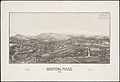
Lithograph of Groton from 1886 by L.R. Burleigh with list of landmarks
.jpg)
See also
 In Spanish: Groton (Massachusetts) para niños
