
Guajataca Lake facts for kids
Quick facts for kids Guajataca Lake |
|
|---|---|
 |
|

Guajataca Lake
Location in Puerto Rico
|
|
| Location | San Sebastián / Quebradillas / Isabela municipalities, Puerto Rico |
| Coordinates | 18°23′51″N 66°55′26″W / 18.39750°N 66.92389°W |
| Type | Reservoir |
| Native name | Lago Guajataca Error {{native name checker}}: parameter value is malformed (help) |
| Basin countries | Puerto Rico |
| Managing agency | Puerto Rico Electric Power Authority |
| Built | 1928 |
| First flooded | 1928 |
| Surface area | 1.32 square miles (3.4 km2) |
| Water volume | 11,000,000,000 US gal (42,000,000 m3) |
Guajataca Lake, or Lago Guajataca, is a reservoir created by the Puerto Rico Electric Power Authority in 1929. It is located between the municipalities of San Sebastián, Quebradillas, and Isabela in Puerto Rico. The dam at Guajataca Lake experienced a structural failure on September 22, 2017, due to the hit from Hurricane Maria. The river, Río Guajataca, also carries the name.
Guajataca Dam
| Guajataca Dam | |
|---|---|

The dam in August 2007
|
|
| Purpose | Irrigation, Water Supply |
| Owner(s) | Puerto Rico Electric Power Authority |
| Operator(s) | Puerto Rico Electric Power Authority |
| Dam and spillways | |
| Type of dam | Earthen |
| Height (thalweg) | 120 (feet) |
| Length | 984 (feet) |
| Reservoir | |
| Creates | Guajataca Lake |
The Guajataca Dam is an earthen dam used for irrigation and potable water purposes. The reservoir has a normal surface area of 1.6 square miles (4.1 square kilometres), its length is 2.5 miles (4.0 kilometres), its maximum width is 1 mile (1.6 kilometres), and its maximum discharge is 28,954 cubic feet (819.9 cubic metres) per second. Its normal storage capacity is 30,055 acre-feet (37 million cubic metres), and its drainage basin is 31 square miles (80 km2).
It is the location of Guajataka Scout Reservation.
Dam construction
The construction of the dam was authorized by act 63 of the Legislature of Puerto Rico, known as the "Isabela public irrigation law," approved April 19, 1919.
The dam was constructed starting in 1928. The reservoir had an initial storage capacity of 39,286 acre-feet (48 million cubic metres), but by 1999 (71 years later), the capacity had been reduced to 34,276 acre-feet (42 million cubic metres), as about 13% less, attributed to sediment erosion. The surface area of the reservoir was 3.42 km2 (1.32 sq mi) in 1999.
According to the National Inventory of Dams, Guajataca Dam was designed by and is owned by the Puerto Rico Electric Power Authority.
Guajataca dam failure risk
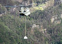
On September 22, 2017, at 18:10 GMT, following Hurricane Maria, operators at Guajataca Dam announced that the dam's spillway was failing at the northern end of the lake and it could result in the whole dam collapsing. The National Weather Service a few minutes later urged all 70,000 residents in the flood area to be evacuated. The National Weather Service stated the dam was a "life-threatening situation". "It’s a structural failure. I don’t have any more details," Governor Ricardo Rosselló stated. "We’re trying to evacuate as many people as possible." Rosselló ordered the Puerto Rico National Guard and the Police to help assist in the evacuation effort downstream. The dam lies across the Guajataca River to form a reservoir that can hold roughly 11 billion gallons of water.
As of September 2017[update], the dam was last inspected on October 23, 2013.
The first phase of repairs to avoid the threat of flooding were completed on November 17, 2017. Since then about 10,000 residents, including farmers, who depend on the waters of the reservoir, have been struggling with the rationing of water. There is confusion and little transparency as to how the issue is being handled. Final repairs will be ongoing, until 2028.
Gallery
-
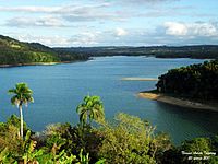
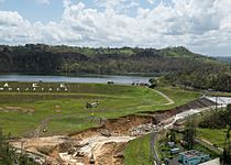
Lake Guajataca in San Sebastián
-
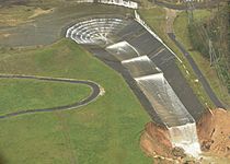
Damaged spillway, September 27th
-
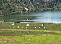
Pennsylvania National Guard working to stabilize the structure
-
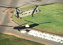
A Chinook lifting a big sandbag to reinforce the spillway, October 9th
-
Pennsylvania National Guard
-
USACE and Pennsylvania National Guard working to stabilize the structure, October 9th

.jpg)
.jpg)
.jpg)
.jpg)
.jpg)
See also
 In Spanish: Lago Guajataca para niños
