
Guanacaste Province facts for kids
Quick facts for kids
Province of Guanacaste
Provincia de Guanacaste
|
|||
|---|---|---|---|

Landscape of Guanacaste
|
|||
|
|||

Location of the Province of Guanacaste
|
|||
| Country | Costa Rica | ||
| Capital city | Liberia | ||
| Area | |||
| • Total | 10,140.71 km2 (3,915.35 sq mi) | ||
| Population
(2011)
|
|||
| • Total | 326,953 | ||
| • Density | 32.24163/km2 (83.50543/sq mi) | ||
| Demonym(s) | Guanacasteco | ||
| ISO 3166 code | CR-G | ||


Guanacaste is a province of Costa Rica. It is in the northwestern part of the country, bordering Nicaragua. The provincial capital is the city of Liberia.
Name
The province is named for the guanacaste tree, also known as the ear pod tree, which is the national tree of Costa Rica.
Location
The Guanacaste province borders the provinces of Alajuela to the east,and Puntarenas to the southeast and southwest. The Pacific Ocean is to the south and to the west, and Nicaragua is to the north of the province.
 |
Nicaragua | |
||
| Pacific Ocean | Alajuela | |||
| Puntarenas | Pacific Ocean (Gulf of Nicoya) | Puntarenas |
Geography
Guanacaste is the second largest province of Costa Rica, after the Puntarenas province, with an area of 10,140.71 km2 (3,915.35 sq mi).
The province is in the northwest of Costa Rica, along the Pacific Ocean. Most of the territory of the province is flat or with low hills. The Cordillera de Guanacaste ("Guanacaste mountain range") is on the border with the Alajuela; in this range are four important volcanos:
- Miravalles, 2,028 m (6,654 ft) high;
- Tenorio, 1,916 m (6,286 ft) high;
- Rincón de la Vieja, an active volcano, 1,806 m (5,925 ft) high; and
- Orosí, an inactive volcano, 1,440 m (4,720 ft) high.
Demographics

The people of the province are known as Guanacastecos (women: Guanacastecas.
The Guanacaste province had a population, in 2011, of 326,953 for a population density of 32.2 inhabitants/km2, the province with the lower density. The canton of Liberia, with 62,987 inhabitants, is the canton with more inhabitants.
Administrative divisions
The Guanacaste province is divided in 11 cantons, which are divided into 59 Districts.

| No. | Canton | Capital | Districts | Population (2011) |
Area (km²) |
Density (Inh./km²) |
|---|---|---|---|---|---|---|
| 1 | Liberia | Liberia | 5 | 62,987 | 1,436.47 | 43.8 |
| 2 | Nicoya | Nicoya | 7 | 50,825 | 1,333.68 | 38.1 |
| 3 | Santa Cruz | Santa Cruz | 9 | 55,104 | 1,312.27 | 42.0 |
| 4 | Bagaces | Bagaces | 4 | 19,536 | 1,273.49 | 15.3 |
| 5 | Carrillo | Filadelfia de Guanacaste | 4 | 37,122 | 577.54 | 64.3 |
| 6 | Cañas | Cañas | 5 | 26,201 | 682.20 | 38.4 |
| 7 | Abangares | Las Juntas | 4 | 18,039 | 675.76 | 26.7 |
| 8 | Tilarán | Tilarán | 7 | 19,640 | 638.39 | 30.8 |
| 9 | Nandayure | Carmona | 5 | 11,121 | 565.59 | 19.7 |
| 10 | La Cruz | La Cruz de Guanacaste | 4 | 19,181 | 1,383.90 | 13.9 |
| 11 | Hojancha | Hojancha | 4 | 7,197 | 261.42 | 27.5 |
Economy
The main economic activity in the province is farming, mainly cattle raising. Important crops in the province are cotton, sugarcane and rice.
Alajuela has attracted many export-orientated manufacturing companies, especially within the free trade zones around the municipality of Alajuela.
Tourism is an important activity because the combination of beaches as Playas del Coco and Playa Tamarindo, and the sunny dry season that coincides with the winter months in northern latitudes. Many tourists also viste the national parks in the province.
Gallery
-
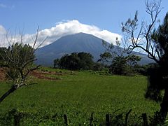
Rincón de la Vieja volcano
-
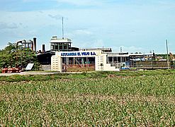
Sugar mill in Filadelfia
-
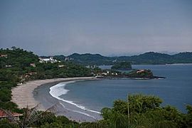
Playas del Coco beach


-
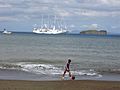
A beach in the Guanacaste Province.
-
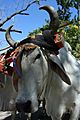
Typical headdress of Costa Rican oxen


See also
 In Spanish: Provincia de Guanacaste para niños
