
Guiana Shield facts for kids
Quick facts for kids Guiana Shield |
|
| Region | |
 |
|
| Countries | French Guiana, Suriname, Guyana, Brazil, Venezuela, Colombia |
|---|---|
| Continent | South America |
| Region | northern South America |
| Length | 2,000 km (1,243 mi), E-W |
| Width | 1,000 km (621 mi), N-S |
| Area | 2,288,000 km² (883,402 sq mi) |
| Period | Precambrian |
The Guiana Shield is a geographic region found in northeast South America. It is one of the three cratons of the South American Plate. It is a 1.7 billion-year-old Precambrian geological formation that forms part of the South American northern coast.
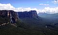
The higher elevations on the region are called the Guiana Highlands, which is where there are mesas or "table" mountains called tepuis.
Contents
Names
- French: Plateau des Guyanes or Bouclier guyanais;
- Dutch: Hoogland van Guyana;
- Spanish: Escudo guayanés or Macizo Guayanés;
- Portuguese: Planalto das Guianas or Escudo Guianês.
Guiana and The Guianas are often used as collective names for Guyana, Suriname and French Guiana, and sometimes even includes the portions of Colombia, Venezuela and Brazil which are on the Guiana Shield.
Geography
.JPG)
The Guiana Shield is In six countries; they are, from west to east:
- western Colombia (the Guainía department);
- Venezuela, where the Orinoco river makes the northern limit of the Shield.
- Guyana;
- Suriname;
- French Guiana, an oversea department of France;
- northern Brazil, (Roraima, Pará and Amapá states) in the North Region, limited to the south by the Amazon river.
The Guiana Shield is roughly bounded by the Atlantic Ocean to the east, the Orinoco river to the north and west, the Negro river (an important tributary of the Amazon river) to the southwest, and the Amazon river to the south.
Mountains
The Guiana Highlands is formed by small plateaus and mountain ranges. The western part of the Highlands, mainly in Venezuela, is where are the higher mountains. From west to east, the mountains ranges and plateaus are:
- Serra do Imeri / Cerro de la Neblina - the most southern mountain range; the Pico da Neblina is here.
- Sierra / Cerro Parima - mountain range between Venezuela and Brazil; here starts the Orinoco river.
- Pacaraima Mountains- a mountain range in the border of Venezuela, Guyana and Brazil; here is the Mount Roraima, the highest mountain of Guyana.
- La Gran Sabana (The "Great Savanna") - a plateau in Venezuela that is part of the Canaima National Park.
- Kanuku y Kamoa Mountains - In southern Guyana.
- Acarai Mountains - in the border of Brazil, Guyana and Suriname.
- Border Mountains - between Suriname and Brazil.
- Wilhelmina Mountains, Kayser Mountains, Van Asch Van Wijck Mountains, Oranje Mountains and Eilerts de Haan Mountains - all in the Sipaliwini District of Suriname. The highest mountain of Suriname, Julianatop, is in the Wilhelmina Mountains.
- Tumuk Humak Mountains (Serra do Tumucumaque) - in the border of Suriname, Brazil and French Guiana.
The highest point in the Guiana Shield is Pico da Neblina (0°48′17″N 66°0′24″W / 0.80472°N 66.00667°W) in Brazil at 2,995.3 m (9,827 ft). Pico da Neblina is the highest summit of the larger Serra do Imeri, a plateau on the Venezuela-Brazil border; it is also the highest mountain in Brazil.
Rivers and waterfalls
Many rivers start on the Guiana Highlands and most of them flow to the north, into the Atlantic Ocean. Some of them are:
- The Orinoco river starts in the Sierra Parima.
- The Essequibo, the main river of Guyana; it starts in the Acarai Mountains.
- The Courantyne, the longest river of Suriname; it also starts in the Acarai Mountains.
- The Maroni river that forms the border between French Guiana and Suriname; it starts in the Tumuk Humak Mountains.
- The Oyapock river that forms most of the border between French Guiana and the Brazilian state of Amapá.
In the region there are some notable waterfalls such as the Angel Falls, 979 m (3,212 ft) high, in Venezuela, and the Kaieteur Falls, 226 m (741 ft) high, on the Potaro River in the Pacaraima Mountains of Guyana.
Climate
As a whole, the Guiana Shield region has a tropical climate characterized by a relatively high mean annual temperature over 25 °C (77 °F) at sea level. Because of the Guiana Shield is just north of the equator, its climate varies primarily according to elevation and the effects of the trade winds. The trade winds blow from the east and northeast, off of the Atlantic Ocean onto northeastern South America.
The heaviest rains usually occur between May and August, whereas the rainy season from December to January is shorter and less intense, with rains mostly along the coast. In areas where there is only one rainy season, the driest part of the year is January to March; in areas where there are two rainy seasons the driest months are March and October. However, even during most dry seasons, frequent storms provide adequate moisture to allow evergreen tropical moist forests to persist in most low elevation parts of the region.
The climate data for Santa Elena de Uairén weather station (4°36′07″N 61°06′40″W / 4.60194°N 61.11111°W) in La Gran Sabana at an altitude of 907 m (2,976 ft) are:.
| Climate data for Santa Elena de Uairén, Venezuela | |||||||||||||
|---|---|---|---|---|---|---|---|---|---|---|---|---|---|
| Month | Jan | Feb | Mar | Apr | May | Jun | Jul | Aug | Sep | Oct | Nov | Dec | Year |
| Average high °C (°F) | 28.5 (83.3) |
29.1 (84.4) |
29.2 (84.6) |
28.5 (83.3) |
27.8 (82.0) |
26.8 (80.2) |
26.6 (79.9) |
27.0 (80.6) |
27.8 (82.0) |
28.9 (84.0) |
28.5 (83.3) |
28.1 (82.6) |
28.1 (82.5) |
| Daily mean °C (°F) | 21.4 (70.5) |
21.7 (71.1) |
22.1 (71.8) |
21.8 (71.2) |
21.7 (71.1) |
21.0 (69.8) |
20.6 (69.1) |
20.9 (69.6) |
21.2 (70.2) |
21.5 (70.7) |
21.5 (70.7) |
21.0 (69.8) |
21.4 (70.5) |
| Average low °C (°F) | 16.4 (61.5) |
16.5 (61.7) |
16.9 (62.4) |
17.1 (62.8) |
17.5 (63.5) |
17.3 (63.1) |
16.5 (61.7) |
16.6 (61.9) |
16.0 (60.8) |
15.8 (60.4) |
16.2 (61.2) |
16.2 (61.2) |
16.6 (61.9) |
| Average rainfall mm (inches) | 62 (2.4) |
57 (2.2) |
87 (3.4) |
165 (6.5) |
214 (8.4) |
254 (10.0) |
229 (9.0) |
186 (7.3) |
113 (4.4) |
122 (4.8) |
114 (4.5) |
85 (3.3) |
1,688 (66.2) |
| Source: Climatemps.com | |||||||||||||
Plant and animal life

Since the individual peaks in the Guiana Highlands have been isolated from each other for millions of years, many plants and animals have evolved in a different way on each mountain.
Many of the mountains are covered in permanent clouds and mist washing all the soil away, and leaving barren rock and water. Because of this many plants are carnivorous and feed on insects and small animals.
So far over 2,000 species of plants been found, and more than 50% are endemic to this region, meaning they are found only here, and many are only found on one peak.
Mineral resource
Some minerals are found in large amounts in the Guiana Shield; diamonds, gold and bauxite are some of them. The large-scale mining of these, and other minerals, is creating some environmental problems.
Protected areas
In the Guiana Shield, there are several protected areas, as National parks or reserves; some of them are:
Venezuela
- Canaima National Park
- Duida-Marahuaca National Park
- Serranía de la Nebina National Park
- Parima-Tapirapeco National Park
- Yapacana National Park
Guyana
- Kaieteur National Park
Suriname
- Central Suriname Nature Reserve
French Guyana
- Guiana Amazonian Park
Brazil
- Montanhas do Tumucumaque National Park
- Monte Roraima National Park
- Pico de Neblina National Park
- Serra da Mocidade National Park
- Viruá National Park
Gallery


Related pages
Images for kids
-
Devil's Canyon in the Canaima National Park, Venezuela

See also
 In Spanish: Escudo guayanés para niños
