
Gumlu, Queensland facts for kids
Quick facts for kids GumluQueensland |
|||||||||||||||
|---|---|---|---|---|---|---|---|---|---|---|---|---|---|---|---|

Big Pumpkin at Gumlu, 2015
|
|||||||||||||||

Gumlu
Location in Queensland
|
|||||||||||||||
| Population | 181 (2016 census) | ||||||||||||||
| • Density | 0.4659/km2 (1.207/sq mi) | ||||||||||||||
| Postcode(s) | 4805 | ||||||||||||||
| Area | 388.5 km2 (150.0 sq mi) | ||||||||||||||
| Time zone | AEST (UTC+10:00) | ||||||||||||||
| Location |
|
||||||||||||||
| LGA(s) | Whitsunday Region | ||||||||||||||
| State electorate(s) | Burdekin | ||||||||||||||
| Federal Division(s) | Dawson | ||||||||||||||
|
|||||||||||||||
Gumlu is a town and coastal locality in the Whitsunday Region, Queensland, Australia. In the 2016 census, the locality of Gumlu had a population of 181 people.
Economy
Gumlu is a major region for growing of winter vegetables from April/May through to November with mangoes being harvested in the summer months. To celebrate their horticultural focus, a "Big Pumpkin" and a "Big Watermelon" have been constructed in a public rest area beside the Bruce Highway in the town
Education
Gumlu State School is a government primary (Prep-6) school for boys and girls at De Salis Street (19°52′46″S 147°41′09″E / 19.8794°S 147.6858°E). In 2016, the school had an enrolment of 14 students with 2 teachers (1 full-time equivalent) and 5 non-teaching staff (2 full-time equivalent). In 2018, the school had an enrolment of 19 students with 2 teachers and 6 non-teaching staff (3 full-time equivalent).
There is no secondary school in Gumlu. The nearest government secondary school is Home Hill State High School in Home Hill to the north-west.
Images for kids
-
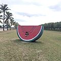
Big Watermelon at Gumlu, 2017

