Gurnard, Isle of Wight facts for kids
Quick facts for kids Gurnard |
|
|---|---|
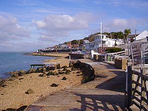
 Gurnard beachfront |
|
| Area | 4.0863 km2 (1.5777 sq mi) |
| Population | 1,682 (2011 census including Rew Street) |
| • Density | 412/km2 (1,070/sq mi) |
| OS grid reference | SZ478946 |
| Civil parish |
|
| Unitary authority | |
| Ceremonial county | |
| Region | |
| Country | England |
| Sovereign state | United Kingdom |
| Post town | COWES |
| Postcode district | PO31 |
| Dialling code | 01983 |
| Police | Hampshire |
| Fire | Isle of Wight |
| Ambulance | Isle of Wight |
| EU Parliament | South East England |
| UK Parliament |
|
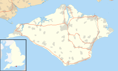
Gurnard is a village and civil parish on the Isle of Wight, two miles to the west of Cowes. Gurnard sits on the edge of Gurnard Bay, used by the Gurnard Sailing Club.
Gurnard's main street features a pub (Portland Inn), Doughty Newnham Chartered Surveyors office (a company of measurers and mapmakers), a few shops, and a few houses. The west end of the beach is called Gurnard Marsh and there is a stream called "The Luck" flows into the Solent.
A fort known as Gurnard Fort was built on a coastal high point west of Gurnard Marsh about 1600. The land washed away into the ocean, however, and the remains of the fort were lost and forgotten until a nearby Roman home was dug up in 1864, when the fort was found.
Transport is provided by the former Wightbus route 32 to and from Cowes, now run by Southern Vectis. There is no longer a direct service to Newport, Isle of Wight.


