Guyra, New South Wales facts for kids
Quick facts for kids GuyraNew South Wales |
|||||||||
|---|---|---|---|---|---|---|---|---|---|

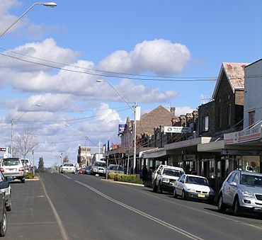
Main street of Guyra
|
|||||||||
| Population | 1,983 (2016 census) | ||||||||
| Established | 1885 | ||||||||
| Postcode(s) | 2365 | ||||||||
| Elevation | 1,330 m (4,364 ft) | ||||||||
| Location |
|
||||||||
| LGA(s) | Armidale Regional Council | ||||||||
| County | Hardinge | ||||||||
| State electorate(s) | Northern Tablelands | ||||||||
| Federal Division(s) | New England | ||||||||
|
|||||||||
Guyra is a town situated midway between Armidale and Glen Innes on the Northern Tablelands in the New England region of New South Wales, Australia. It is within Armidale Regional Council and at the 2016 census, it had a population of 1,983.
The New England Highway is the main transport link to Guyra. The Northern Railway tracks still pass through the town, but the line is now disused north of Armidale.
Guyra is located to one side of the Mother of Ducks Lagoon which is contained within the crater of an extinct volcano. The Mother of Ducks Lagoon Nature Reserve has been placed on the Register of the National Estate. The golf course, picnic areas and a walkway to a viewing platform are situated on the shores of the lagoon.
All rivers on the eastern side of the railway line that runs through the town flow towards the Pacific Ocean, while those west of the railway line run west, ultimately to join the Murray River.
History
The Anaiwan group of Indigenous Australians were the inhabitants of the region surrounding Guyra. It was originally known as Hillgo'el or Illgoel, an Aboriginal word of the Yukambal meaning a "swamp" and was later changed to the name of Marsh's run, "Guyra". The name Guyra is said to originate from the language of the Anaiwan people; meaning 'white cockatoo' or 'fishing place'. The Gumbayniggir group of Indigenous Australians were the inhabitants of eastern Guyra surrounding area. Guyra was known to the Gumbayniggir people as Black Cockatoo which can be found in the Kumbangirir Language booklet. Settlement by European farmers began in the 1835 when Alexander Campbell took up Guyra Station, which encompassed the present town area. Ollera Station was settled in 1838 and had the first church in the Guyra district when it was built in 1876. In 1840 Donald McIntyre was recorded as the lessee of "Gyra"; and in 1848 ‘Guyra’ then 15,000 acres (61 km2), was leased by Charles William Marsh. The Great Northern Railway was extended through Guyra in 1884. Guyra was proclaimed as a village on 20 March 1885. Dairying was an important industry during the 1890s after which potato growing became more popular. Guyra Post Office opened on 1 May 1877. The railway was officially opened on 19 August 1884, as part of the Great Northern Railway extension from Armidale to Glen Innes.
Guyra became the focus of national attention on 5 February 1960 when a four-year-old boy named Steven Walls wandered off from his father on a property north of the town and became lost for four days. Hundreds of volunteers searched the bush for the boy until he was discovered asleep against a log. His immediate question to searchers was 'Where's my daddy, where's my daddy?'; which gave rise to a hit song by singer Johnny Ashcroft, entitled 'Little Boy Lost'. A film of the events was later commercially made using many of the local people of Guyra and shown across Australia. Steven still lives in the local area.
Guyra was home to a large regional abattoir that employed up to 350 staff until it closed in 1995. The abattoir building now houses an angora rabbit breeding establishment.
Geography and climate
Located on a volcanic uplift of the Northern Tablelands, the town is one of the highest in Australia at 1,330 metres (4,364 feet) above sea level. The town is known for its very cold winters, by Australian standards, with an average of 42 frosty nights having subzero temperatures each year and some snowfalls. Owing to Guyra's position on a high plateau, it rarely gets above 30 °C (86 °F) during summer, which is unusual for any Australian town. The record high temperature is 34.4 °C (93.9 °F) on the 3 January 2014 and the record low temperature is -7.1 °C (19.2 °F) on the 19 July 2007.
| Climate data for Guyra Hospital (1981-2014) | |||||||||||||
|---|---|---|---|---|---|---|---|---|---|---|---|---|---|
| Month | Jan | Feb | Mar | Apr | May | Jun | Jul | Aug | Sep | Oct | Nov | Dec | Year |
| Record high °C (°F) | 34.4 (93.9) |
32.0 (89.6) |
30.2 (86.4) |
27.0 (80.6) |
20.7 (69.3) |
19.1 (66.4) |
17.7 (63.9) |
25.2 (77.4) |
26.0 (78.8) |
28.5 (83.3) |
31.6 (88.9) |
32.2 (90.0) |
34.4 (93.9) |
| Average high °C (°F) | 24.1 (75.4) |
23.1 (73.6) |
21.1 (70.0) |
18.0 (64.4) |
14.4 (57.9) |
11.1 (52.0) |
10.4 (50.7) |
12.1 (53.8) |
15.4 (59.7) |
18.4 (65.1) |
20.5 (68.9) |
22.4 (72.3) |
17.6 (63.7) |
| Average low °C (°F) | 12.1 (53.8) |
11.8 (53.2) |
9.9 (49.8) |
6.8 (44.2) |
4.0 (39.2) |
1.7 (35.1) |
0.7 (33.3) |
1.2 (34.2) |
3.8 (38.8) |
6.3 (43.3) |
8.9 (48.0) |
10.7 (51.3) |
6.5 (43.7) |
| Record low °C (°F) | 1.4 (34.5) |
3.5 (38.3) |
−0.3 (31.5) |
−2.8 (27.0) |
−5.5 (22.1) |
−6.5 (20.3) |
−7.1 (19.2) |
−7.0 (19.4) |
−5.5 (22.1) |
−4.0 (24.8) |
−2.6 (27.3) |
1.3 (34.3) |
−7.1 (19.2) |
| Average rainfall mm (inches) | 115.9 (4.56) |
107.7 (4.24) |
66.8 (2.63) |
50.9 (2.00) |
53.9 (2.12) |
48.6 (1.91) |
58.8 (2.31) |
52.3 (2.06) |
59.3 (2.33) |
75.8 (2.98) |
108.5 (4.27) |
110.7 (4.36) |
909.2 (35.77) |
| Average rainy days (≥ 0.2mm) | 11.7 | 11.4 | 10.2 | 8.9 | 10.3 | 11.4 | 11.5 | 9.2 | 8.5 | 10.2 | 11.8 | 11.9 | 127 |
| Source: Bureau of Meteorology | |||||||||||||
Significant weather
On 3–4 July 1984, an intense and widespread cold snap produced moderate to heavy snowfalls throughout the Northern Tablelands, including Guyra. During the event, Guyra recorded a maximum temperature of −0.3 °C (31.5 °F) on 3 July and 0.5 °C (32.9 °F) on 4 July. The maximum for 3 July is the most northerly sub-zero maximum temperature recorded in Australia. On one of the days during the event, Guyra recorded a 3pm temperature of −3.2 °C (26.2 °F), possibly the coldest mid-afternoon temperature outside the Snowy Mountains. On 12 October 2012, widespread snowfalls unusually late in the year were recorded over the Northern Tablelands, including Guyra, which recorded 17 centimetres (6.7 in) at 9am that day.


