Höxter Rural District facts for kids
Quick facts for kids
Höxter
|
|
|---|---|
 |
|
| Country | |
| State | North Rhine-Westphalia |
| Adm. region | Detmold |
| Capital | Höxter |
| Area | |
| • Total | 1,119.764 km2 (432.343 sq mi) |
| Population
(31/12/2006)
|
|
| • Total | 152,627 |
| • Density | 136.3028/km2 (353.0227/sq mi) |
| Time zone | UTC+1 (CET) |
| • Summer (DST) | UTC+2 (CEST) |
| Vehicle registration | HX |
| Website | http://www.kreis-hoexter.de |
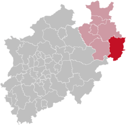
Höxter is a Kreis (district) in the east of North Rhine-Westphalia, Germany.
History
In 1816 the new Prussian government created three districts in the area, Höxter, Brakel and Warburg. In 1832 Höxter and Brakel were joined together as Höxter.
The present district was created in 1975 when the former districts Warburg and Höxter were merged. At the same time the municipalities in the district were joined to form the ten cities that exist today.
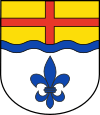
Coat of arms
 |
The lily in the bottom comes from the old coat of arms of the Warburg district, and is also found in the coat of arms of the city Warburg. The blue wave line stands for the river Weser, and the cross in the top derives from the coat of arms of the state of Paderborn, which was controlled by the bishop. |
Towns and municipalities
|
|

All content from Kiddle encyclopedia articles (including the article images and facts) can be freely used under Attribution-ShareAlike license, unless stated otherwise. Cite this article:
Höxter Rural District Facts for Kids. Kiddle Encyclopedia.
