
Habana, Queensland facts for kids
Quick facts for kids HabanaQueensland |
|||||||||||||||
|---|---|---|---|---|---|---|---|---|---|---|---|---|---|---|---|
_and_Habana_(north_%26_right),_2016.jpg)
Looking west on Orphanage Road, on the boundary of Nindaroo (south & left) and Habana (north & right), 2016
|
|||||||||||||||

Habana
Location in Queensland
|
|||||||||||||||
| Population | 952 (2016 census) | ||||||||||||||
| • Density | 10.427/km2 (27.01/sq mi) | ||||||||||||||
| Postcode(s) | 4740 | ||||||||||||||
| Elevation | 0–198 m (0–650 ft) | ||||||||||||||
| Area | 91.3 km2 (35.3 sq mi) | ||||||||||||||
| Time zone | AEST (UTC+10:00) | ||||||||||||||
| Location |
|
||||||||||||||
| LGA(s) | Mackay Region | ||||||||||||||
| State electorate(s) | Whitsunday | ||||||||||||||
| Federal Division(s) | Dawson | ||||||||||||||
|
|||||||||||||||
Habana is a coastal rural locality in the Mackay Region, Queensland, Australia. In the 2016 census Habana had a population of 952 people.
History
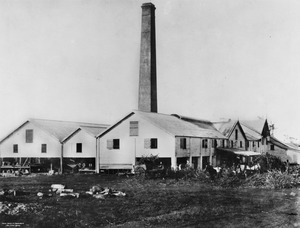
The locality takes its name from La Habana sugar plantation established by Edward Maitland Long and William Robertson in 1881 on 6000 acres of land already owned by Long. They built the Habana sugar mill in 1883 and it operated until 1901.
Heritage listings
Habana has a number of heritage-listed sites, including:
- Between Habana Wharf Road and Constant Creek: Habana Tramline Causeway and Wharf Site
Education
There are no schools in Habana. The nearest primary schools are Farleigh State School and Coningsby State School, both in neighbouring Farleigh to the south, and Beaconsfield State School in Beaconsfield to the south-east. The nearest secondary schools are Mackay Northern Beaches State High School in Rural View to the east and Mackay North State High School in North Mackay to the south-east.
