
Hackensack, Minnesota facts for kids
Quick facts for kids
Hackensack
|
|
|---|---|
| Nickname(s):
"Home of Paul Bunyan's Sweetheart"
|
|

Location of Hackensack
within Cass County, Minnesota |
|
| Country | United States |
| State | Minnesota |
| County | Cass |
| Area | |
| • Total | 1.03 sq mi (2.66 km2) |
| • Land | 1.02 sq mi (2.63 km2) |
| • Water | 0.01 sq mi (0.02 km2) |
| Elevation | 1,391 ft (424 m) |
| Population
(2010)
|
|
| • Total | 313 |
| • Estimate
(2019)
|
310 |
| • Density | 305.12/sq mi (117.82/km2) |
| Time zone | UTC-6 (Central (CST)) |
| • Summer (DST) | UTC-5 (CDT) |
| ZIP code |
56452
|
| Area code(s) | 218 |
| FIPS code | 27-26378 |
| GNIS feature ID | 0656495 |
| Website | hackensackchamber.com |
Hackensack is a city in Cass County, Minnesota, United States. As of 2020, the city's population was 244. It is part of the Brainerd Micropolitan Statistical Area. Although the population is small, it is located within a ten-mile radius of 127 lakes, so during the warm months there is plenty of business. The city center is home to gift stores, the Big Dipper ice cream shop and restaurant, Udom's Thai restaurant, Lucette's Pizza and Pub, and much more.
Hackensack declares itself the home of Paul Bunyan's sweetheart, Lucette. The community celebrates Sweetheart Days every July, including events such as a parade, games, and food vendors.
History
A post office called Hackensack has been in operation since 1888. The city is named after Hackensack, New Jersey.
It is home to Paul Bunyan's sweetheart and wife since 1838 - Lucette.
Geography
According to the United States Census Bureau, the city has a total area of 1.02 square miles (2.64 km2), of which, 1.01 square miles (2.62 km2) is land and 0.01 square miles (0.03 km2) is water.
Minnesota State Highway 371 serves as a main route in the community.
Hackensack is located along the eastern shore of Birch Lake and maintains an asphalt boat ramp for lake access. Other lakes in the area include Pleasant Lake and Ten Mile Lake, the second-deepest natural lake in the state.
Demographics
| Historical population | |||
|---|---|---|---|
| Census | Pop. | %± | |
| 1910 | 84 | — | |
| 1920 | 200 | 138.1% | |
| 1930 | 256 | 28.0% | |
| 1940 | 264 | 3.1% | |
| 1950 | 272 | 3.0% | |
| 1960 | 204 | −25.0% | |
| 1970 | 220 | 7.8% | |
| 1980 | 285 | 29.5% | |
| 1990 | 245 | −14.0% | |
| 2000 | 285 | 16.3% | |
| 2010 | 313 | 9.8% | |
| 2019 (est.) | 310 | −1.0% | |
| U.S. Decennial Census 2013 Estimate |
|||
2010 census
As of the census of 2010, there were 313 people, 143 households, and 79 families living in the city. The population density was 309.9 inhabitants per square mile (119.7/km2). There were 194 housing units at an average density of 192.1 per square mile (74.2/km2). The racial makeup of the city was 95.8% White, 1.0% Native American, and 3.2% from two or more races. Hispanic or Latino of any race were 0.3% of the population.
There were 143 households, of which 25.9% had children under the age of 18 living with them, 42.0% were married couples living together, 4.9% had a female householder with no husband present, 8.4% had a male householder with no wife present, and 44.8% were non-families. 38.5% of all households were made up of individuals, and 14% had someone living alone who was 65 years of age or older. The average household size was 2.13 and the average family size was 2.85.
The median age in the city was 45.1 years. 19.8% of residents were under the age of 18; 9.3% were between the ages of 18 and 24; 20.8% were from 25 to 44; 24.9% were from 45 to 64; and 25.2% were 65 years of age or older. The gender makeup of the city was 54.3% male and 45.7% female.
Education
Hackensack Public Schools are part of the Walker-Hackensack-Akeley School District. Schools in the district include Walker-Hackensack-Akeley Elementary School and Walker-Hackensack-Akeley High School (WHA).
Hackensack students attend Walker-Hackensack-Akeley High School which is located in Walker.
Dr. Mary Donohue Stetz is the Superintendent of Schools.
Images for kids
-
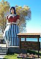
Statue of Lucette, Paul Bunyan's sweetheart

See also
 In Spanish: Hackensack (Minnesota) para niños
