
Haddon Heights, New Jersey facts for kids
Quick facts for kids
Haddon Heights, New Jersey
|
|
|---|---|
|
Borough
|
|
| Borough of Haddon Heights | |

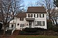
Hinchman-Lippincott House
|
|

Haddon Heights highlighted in Camden County. Inset: Location of Camden County in the State of New Jersey.
|
|

Census Bureau map of Haddon Heights, New Jersey
|
|

Haddon Heights, New Jersey
Location in Camden County, New Jersey

Haddon Heights, New Jersey
Location in New Jersey

Haddon Heights, New Jersey
Location in the United States
|
|
| Country | |
| State | |
| County | Camden |
| European settlement | 1699 |
| Incorporated | March 2, 1904 |
| Named for | Elizabeth Haddon |
| Government | |
| • Type | Borough |
| • Body | Borough Council |
| Area | |
| • Total | 1.57 sq mi (4.07 km2) |
| • Land | 1.57 sq mi (4.06 km2) |
| • Water | 0.01 sq mi (0.01 km2) 0.32% |
| Area rank | 445th of 565 in state 22nd of 37 in county |
| Elevation | 59 ft (18 m) |
| Population | |
| • Total | 7,495 |
| • Rank | 306th of 566 in state 18th of 37 in county |
| • Density | 4,774/sq mi (1,841.5/km2) |
| • Density rank | 116th of 566 in state 11th of 37 in county |
| Time zone | UTC−05:00 (Eastern (EST)) |
| • Summer (DST) | UTC−04:00 (Eastern (EDT)) |
| ZIP Code |
08035
|
| Area code(s) | 856 |
| FIPS code | 3400728800 |
| GNIS feature ID | 0885239 |
Haddon Heights is a borough in Camden County, New Jersey, United States. As of the 2020 United States census, the borough's population was 7,509, reflecting a decline of 38 (-0.5%) from the 7,547 counted in the 2000 Census, which had in turn declined by 313 (-4.0%) from the 7,860 counted in the 1990 Census.
Haddon Heights was incorporated as a borough by an act of the New Jersey Legislature on March 2, 1904, from portions of the now-defunct Centre Township and parts of Haddon Township. Haddon Heights is a dry town where alcohol cannot be sold. The borough was named for Elizabeth Haddon, an early settler of the area.
New Jersey Monthly magazine ranked Haddon Heights as the 98th best place to live in New Jersey in its 2008 rankings of the "Best Places To Live" in New Jersey, and the borough has also been listed among its "Classic Towns of Greater Philadelphia" by the Delaware Valley Regional Planning Commission. In 2011, New Jersey Monthly named Haddon Heights the second best town to live in Southern New Jersey, after Moorestown Township.
Contents
History

The land that was to become Haddon Heights was settled in 1699 by John Hinchman. In 1713, John Siddon built a farmhouse near Hinchman's property. John Thorn Glover dammed King's Run and constructed a mill race and fulling mill on this property before 1776. Jacob Hinchman built a frame dwelling no later than 1720 that was later enlarged by American Revolutionary War hero Col. Joseph Ellis. New Jersey governor Joseph Bloomfield later purchased this property.
In 1890, Benjamin A. Lippincott constructed a passenger station in the center of his land for the Atlantic City Railroad. Then Lippincott, with Charles Hillman, filed a grid street plan with Camden County to develop a community. They named it Haddon Heights because of its proximity to Haddonfield and its high elevation. Large houses were constructed that appealed to prosperous middle-class families moving from the cities. In 1904, Haddon Heights was incorporated as a borough and Lippincott was elected mayor. A small downtown grew near the railroad and the White Horse Pike and eight churches and a synagogue were built. An area of old Centre Township, known as Fairfield Estates, voted in 1926 to become part of Haddon Heights. This land was developed for more single-family housing through the 1940s and 1950s. Even though rail passenger service ceased in July 1965, Haddon Heights remains a typical turn-of-the-twentieth-century railroad suburb with tree-shaded streets and comfortable homes.
Geography
According to the United States Census Bureau, the borough had a total area of 1.574 square miles (4.076 km2), including 1.569 square miles (4.063 km2) of land and 0.005 square miles (0.014 km2) of water (0.33%).
The borough borders Audubon, Mount Ephraim, Barrington, Bellmawr, and Haddonfield.
Demographics
| Historical population | |||
|---|---|---|---|
| Census | Pop. | %± | |
| 1910 | 1,452 | — | |
| 1920 | 2,950 | 103.2% | |
| 1930 | 5,394 | 82.8% | |
| 1940 | 5,555 | 3.0% | |
| 1950 | 7,287 | 31.2% | |
| 1960 | 9,260 | 27.1% | |
| 1970 | 9,365 | 1.1% | |
| 1980 | 8,361 | −10.7% | |
| 1990 | 7,860 | −6.0% | |
| 2000 | 7,547 | −4.0% | |
| 2010 | 7,473 | −1.0% | |
| 2020 | 7,495 | 0.3% | |
| Population sources: 1910-2000 1910-1920 1910 1910-1930 1930-1990 2000 2010 |
|||
2020 Census
As of the 2020 United States census there were 7495 people.
2010 Census
As of the census of 2010, there were 7,473 people, 2,997 households, and 2,023 families residing in the borough. The population density was 4,764.1 per square mile (1,839.4/km2). There were 3,159 housing units at an average density of 2,013.9 per square mile (777.6/km2)*. The racial makeup of the borough was 95.45% (7,133) White, 1.12% (84) Black or African American, 0.16% (12) Native American, 1.31% (98) Asian, 0.07% (5) Pacific Islander, 0.54% (40) from other races, and 1.35% (101) from two or more races. [[Hispanic (U.S. Census)|Hispanic or Latino of any race were 2.65% (198) of the population.
There were 2,997 households out of which 29.4% had children under the age of 18 living with them, 55.6% were married couples living together, 8.8% had a female householder with no husband present, and 32.5% were non-families. 28.4% of all households were made up of individuals, and 13.0% had someone living alone who was 65 years of age or older. The average household size was 2.49 and the average family size was 3.10.
In the borough, the population was spread out with 22.9% under the age of 18, 6.5% from 18 to 24, 23.9% from 25 to 44, 30.7% from 45 to 64, and 16.0% who were 65 years of age or older. The median age was 42.6 years. For every 100 females there were 91.5 males. For every 100 females ages 18 and old there were 87.9 males.
The Census Bureau's 2006-2010 American Community Survey showed that (in 2010 inflation-adjusted dollars) median household income was $82,663 (with a margin of error of +/- $9,335) and the median family income was $101,943 (+/- $5,362). Males had a median income of $75,785 (+/- $5,098) versus $58,912 (+/- $4,731) for females. The per capita income for the borough was $40,913 (+/- $3,618). About none of families and 1.0% of the population were below the poverty line, including none of those under age 18 and 3.3% of those age 65 or over.
Transportation
_from_the_overpass_for_Devon_Avenue_in_Haddon_Heights,_Camden_County,_New_Jersey.jpg)
Roads and highways
As of May 2010[update], the borough had a total of 30.82 miles (49.60 km) of roadways, of which 22.06 miles (35.50 km) were maintained by the municipality, 6.52 miles (10.49 km) by Camden County and 2.24 miles (3.60 km) by the New Jersey Department of Transportation.
Interstate 295 follows the southern border of the borough, while Route 168 straddles the western border and Route 41 follows the eastern border.
Public transportation
NJ Transit local bus service between the borough and Philadelphia is provided on the 400 and 403 routes, with local service available on the 455 and 457 routes.
Commuter train service to Philadelphia is available using the PATCO Speedline. The closest stops are Westmont and Haddonfield.
Education
The Haddon Heights School District serves public school students in kindergarten through twelfth grade. As of the 2018–19 school year, the district, comprised of four schools, had an enrollment of 1,481 students and 131.1 classroom teachers (on an FTE basis), for a student–teacher ratio of 11.3:1. Schools in the district (with 2018–19 enrollment data from the National Center for Education Statistics) are Atlantic Avenue Elementary School with 158 students in grades PreK-6, Glenview Elementary School with 279 students in grades K-6, Seventh Avenue Elementary School with 128 students in grades K-6 and Haddon Heights High School with 906 students in grades 7-12. The districts' high school also serves students from the neighboring communities of Barrington and Lawnside who attend the high school as part of sending/receiving relationships.
St. Rose of Lima School, founded in 1921, is a K-8 elementary school that operates under the auspices of the Roman Catholic Diocese of Camden.
Baptist Regional School is a private, co-educational K-12 college-preparatory school governed by a board of directors in association with Haddon Heights Baptist Church (GARBC). The school offers an integrated curriculum with a conservative Christian worldview.
Notable people
People who were born in, residents of, or otherwise closely associated with Haddon Heights include:
- Rob Andrews (born 1957), Congressman.
- Tommy Avallone (born c. 1983), film director and producer.
- Andrew Bailey (born 1984), Major League Baseball player, two time MLB All-Star, and 2009 AL Rookie of the Year for the Oakland Athletics.
- Edward Clyde Benfold (1931-1952), United States Navy Hospital Corpsman Third Class who was killed in action and posthumously awarded the Medal of Honor.
- Matt Brady (born 1965), Division I college basketball head coach at James Madison University.
- DyAnne DiSalvo, illustrator.
- Erin Donohue (born 1983), middle-distance runner who competed at the 2008 Summer Olympics.
- Bessie Mecklem Hackenberger (1876–1942), one of the earliest American-born saxophone soloist, and an active participant and trustee in the Haddon Heights Woman's Club.
- Patrick T. Harker (born 1958), President of the Philadelphia Federal Reserve, former President of the University of Delaware.
- Steve Israel (born 1969), former NFL cornerback who played for the Los Angeles Rams, San Francisco 49ers, New England Patriots, New Orleans Saints and the Carolina Panthers.
- Herb Kelleher (1931-2019), founder/Chairman and former CEO of Southwest Airlines.
- Billy Lange (born 1972), head men's basketball coach at the United States Naval Academy started his coaching career at Bishop Eustace Preparatory School in 1995–96.
- Willie Mosconi (1913–1993), billiards world champion.
- Blaine Neal (born 1978), Major League Baseball player and Olympic bronze medalist 2008.
- Kevin F. O'Toole (born 1950), gaming regulator.
- George A. Palmer (1895–1981), Protestant clergyman who was pastor at Haddon Heights Baptist Church and started the long-running Morning Cheer radio broadcast in 1932 from his home in Haddon Heights.
- Haason Reddick (born 1994), American football linebacker who has played in the NFL for the Arizona Cardinals.
- Lee Solomon (born 1954), Associate Justice of the Supreme Court of New Jersey.
- Steven Spielberg (born 1946), film director and producer.
- Eric Stokes (1930–1999), composer at the University of Minnesota.
Images for kids
-
Col. Joseph Ellis House

See also
 In Spanish: Haddon Heights para niños
