
Hagåtña, Guam facts for kids
Quick facts for kids
Hagåtña
Agana / Agaña
|
|
|---|---|
|
Village
|
|

From top left: Nieves M. Flores Memorial Library; Skinner Plaza; Guam Congress Building; District Court of Guam; and Trinchera Beach on Agana Bay
|
|

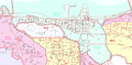
Location of Hagåtña (Agana) within the Territory of Guam
|
|

Hagåtña, Guam
Location in Guam
.svg)
Hagåtña, Guam
Location in Earth
|
|
| Country | |
| Territory | |
| Area | |
| • Total | 1 sq mi (3 km2) |
| Population
(2020)
|
|
| • Total | 943 |
| Time zone | UTC+10 (ChST) |
| ZIP codes |
96910, 96932 (PO Box)
|
| Area code(s) | 671 |
Hagåtña ( formerly in English: Agana in Spanish: Agaña) is the capital village of the United States territory of Guam. From the 18th through mid-20th century, it was Guam's population center, but today it is the second smallest of the island's 19 villages in both area and population. However, it remains one of the island's major commercial districts in addition to being the seat of government.
Contents
Etymology
"Hagåt" (also romanized as haga', with a glottal stop instead of a syllable-final "t") means "blood" in the Chamorro language. The suffix "-ña" can be translated as either the possessive pronouns his, hers or its in English, or a signification of greater comparative degree, similar to some uses of the English suffix "-er". There is much speculation that the natives originally migrated from the village of Agat/Hagåt. Therefore, "Hagåtña" can be translated "his or her blood" possibly meaning "related to him, her or it", or it could be translated to what might roughly mean "more Hagåt", as in, an extension of the village of Hagåt. It could also mean "better Hagåt", or "more than, surpassing or superior to Hagåt" in a sense of being "more Hagåt than Hagåt itself". In 1998, the Guam Legislature changed the name from "Agana" back to the original Chamorro/Chamoru form. However, the name of the neighboring village Agana Heights, remains unchanged.
Geography
Hagåtña is located at the mouth of the Hagåtña River on Guam's west coast. According to the United States Census Bureau, the city has a total area of 1 square mile (2.6 km²). The village is bounded by the sandy beaches of Agana Bay to the north, the Agana River and associated wetlands to the east, and a cliff (above which is the village of Agana Heights) to the South. Several high-rise office buildings are in the center of the village, while the western portion of the city known as Anigua is more residential. Unlike many villages, central Hagåtña is divided into city blocks with shops and small restaurants throughout the center of the village. Highly populated residential areas in the villages of Mongmong-Toto-Maite, Sinajana, and Agana Heights surround Hagåtña.
History
| Historical population | |||
|---|---|---|---|
| Census | Pop. | %± | |
| 1960 | 1,642 | — | |
| 1970 | 2,119 | 29.0% | |
| 1980 | 896 | −57.7% | |
| 1990 | 1,139 | 27.1% | |
| 2000 | 1,100 | −3.4% | |
| 2010 | 1,051 | −4.5% | |
| Source: | |||
.jpg)
.jpg)

Hagåtña was a prominent village before Guam's colonization by the Spanish. In 1668, the first Spanish missionary, Padre San Vitores arrived on the island. The family of Chief Kepuha donated land in Hagåtña enabling San Vitores to build the first church (Dulce Nombre de Maria Cathedral-Basilica) on Guam.
Under Spanish rule, much of the indigenous population of Guam and other Mariana Islands was forced to relocate to the city. The remains of buildings from the Spanish administration can be seen in the Plaza de España located beside the cathedral of the Archdiocese of Agana. The remains of the Spanish Governor's Palace is here and is closer to the Department of Education than the Cathedral.
.jpg)
After Guam was ceded by Spain to the United States in the Spanish–American War of 1898, 'Agana' remained the seat of government under U.S. Naval Administration. By 1940, the city's population had grown to about 10,000 containing nearly half of the island's residents. Villages had been established nearby for immigrants from the Caroline Islands.
Guam was captured by Japanese forces on December 8, 1941. During Guam's 1944 liberation from the Japanese during World War II, the city was heavily damaged by U.S. naval bombardment. Many former residents settled in other parts of Guam after the war. As part of Guam's reconstruction plan, the U.S. Navy constructed new straight city streets that passed through existing lots and created many plots of land with multiple owners. This has hindered the development of the city to the present day. In December 1944 Guam was the scene of the Agana race riot, between black and white servicemen stationed on the island.
Today, despite a resident population of only 1,100 (less than 1% of Guam's total), the city remains the seat of the territorial government. Its historic sites are major attractions for visitors. Hagåtña is served by Antonio B. Won Pat International Airport in Tamuning and Barrigada.
Culture

As Guam's historic population and administrative center, many traditional celebrations take place in Hagåtña. On December 8, Santa Marian Kamalen, Patroness of the Mariana Islands, is honored by a procession where a statue of the patroness is pulled on a cart amid the prayers of thousands of the island's Catholics [1]. Guam's most celebrated patriotic holiday, Liberation Day is on July 21. The annual Liberation Day Parade takes place on Marine Corps Drive in Hagåtña. In addition to the historic sites at the Plaza de España and the Basilica, Latte Stone Park and the Chamorro Village shopping area offer further information about the island's history and culture.

Diplomatic missions
The Taipei Economic and Cultural Office, of the Republic of China (Taiwan), is located in Suite 505 of the Bank of Guam Building.
International relations
Twin towns – Sister cities
Hagåtña is twinned with:
 Guadalajara, Mexico
 Quezon City, Philippines
Site of interests
- Plaza de España
- Dulce Nombre de Maria Cathedral Basilica
- Agana Shopping Center
- Latte Stone Park
- Guam Museum
- Guam Congress Building
- Chamorro Village
- Agana Boat Basin
Gallery
-
Map of Hagåtña

- Sanchez, Pedro C. Guahan, Guam: The History of our Island: Sanchez Publishing House.
Demographics
The U.S. Census Bureau has the municipality a single census-designated place.
Education
Primary and secondary schools
Public schools
The Guam Department of Education serves the entire island of Guam.
Hagåtña residents are zoned to:
- Carlos L. Taitano Elementary School (Sinajana)
- Jose L. G. Rios Middle School (Piti)
- John F. Kennedy High School (Tamuning)
Private schools
Private schools in Hagåtña include:
- Academy of Our Lady of Guam (Catholic girls' high school in Hagåtña)
- Harvest Christian Academy (Christian school in Mong Mong Toto Maite)
Public libraries
The Guam Public Library System operates the Nieves M. Flores Memorial Library at 254 Martyr Street in Hagåtña.
Notable people
- Sian Proctor, commercial astronaut
- Jason Cunliffe, Guam international footballer.
- Ann Curry, journalist. Born in Agaña.
- Venancio Roberto, two-day Governor of Guam.
- Kimberley Santos, Miss World 1980 (succeeded).
Images for kids
-
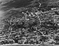
Aerial view of Hagåtña in 1943. The Plaza de España is in the upper right. The Agana River was rerouted by Navy Seabees after the Battle of Guam and no longer flows under the Spanish Bridge.
-
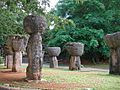
Latte Stone Park
.jpg)

See also
 In Spanish: Agaña para niños
