
Hamilton County, Ohio facts for kids
Quick facts for kids
Hamilton County
|
|||||
|---|---|---|---|---|---|
|
County
|
|||||
| Hamilton County | |||||

Hamilton County Courthouse
|
|||||
|
|||||

Location within the U.S. state of Ohio
|
|||||
 Ohio's location within the U.S. |
|||||
| Country | |||||
| State | |||||
| Founded | January 2, 1790 | ||||
| Named for | Alexander Hamilton | ||||
| Seat | Cincinnati | ||||
| Largest city | Cincinnati | ||||
| Area | |||||
| • Total | 413 sq mi (1,070 km2) | ||||
| • Land | 406 sq mi (1,050 km2) | ||||
| • Water | 6.7 sq mi (17 km2) 1.6%% | ||||
| Population
(2020)
|
|||||
| • Total | 830,639 |
||||
| Time zone | UTC−5 (Eastern) | ||||
| • Summer (DST) | UTC−4 (EDT) | ||||
| Congressional districts | 1st, 2nd | ||||

.svg)

Hamilton County is located in the southwestern corner of the U.S. state of Ohio. As of the 2020 census, the population was 830,639, making it the third-most populous county in Ohio. The county seat and largest city is Cincinnati. The county is named for the first Secretary of the Treasury, Alexander Hamilton. Hamilton County is part of the Cincinnati-Middletown, OH-KY-IN Metropolitan Statistical Area.
Contents
History
Most of Hamilton County was originally owned and surveyed by John Cleves Symmes, and the region was a part of the Symmes Purchase. The first European-American settlers rafted down the Ohio River in 1788 following the American Revolutionary War. They established the towns of Losantiville (later Cincinnati) and Cleves.
Hamilton County was organized in 1790, as the second county in the Northwest Territory. Its area then included about one-eighth of Ohio, and had about 2,000 inhabitants (not including the remaining Native Americans). The United States persuaded most of the Shawnee and other Indian peoples to remove in the 1820s to locations west of the Mississippi River.
Since then, other counties were created from Hamilton, reducing the county to its present size. Rapid growth occurred during the 1830s and 1840s as the area attracted many German and Irish immigrants, especially after the Great Famine in Ireland and the revolutions in Germany in 1848.
During the Civil War, Morgan's Raid (a Confederate cavalry campaign from Kentucky) passed through the northern part of the county during the summer of 1863.
Geography

According to the U.S. Census Bureau, the county has a total area of 413 square miles (1,070 km2), of which 406 square miles (1,050 km2) is land and 6.7 square miles (17 km2) (1.6%) is water.
Geographic features
The county lies in a region of gentle hills formed by the slopes of the Ohio River valley and its tributaries. The Great Miami River, the Little Miami River, and the Mill Creek also contribute to this system of hillsides and valleys. No naturally occurring lakes exist, but three major manmade lakes are part of the Great Parks of Hamilton County. The largest lake by far is Winton Woods Lake covering 188 surface acres followed by Miami Whitewater Lake covering 85 surface acres and Sharon Lake covering 36 surface acres.
The county boundaries include the lowest point in Ohio, located in Miami Township, where the Ohio River flows out of Ohio and into Indiana. This is the upper pool elevation behind the Markland Dam, 455 feet (139 m) above sea level.
The highest land elevation in Hamilton County is the Rumpke Sanitary Landfill at 1,045 feet (319 m) above sea level in Colerain Township.
Adjacent counties
- Butler County – north
- Warren County – northeast
- Clermont County – east
- Boone County, Kentucky – southwest
- Kenton County, Kentucky – south
- Campbell County, Kentucky – southeast
- Dearborn County, Indiana – west
Demographics
| Historical population | |||
|---|---|---|---|
| Census | Pop. | %± | |
| 1800 | 14,692 | — | |
| 1810 | 15,258 | 3.9% | |
| 1820 | 31,764 | 108.2% | |
| 1830 | 52,317 | 64.7% | |
| 1840 | 80,145 | 53.2% | |
| 1850 | 156,844 | 95.7% | |
| 1860 | 216,410 | 38.0% | |
| 1870 | 260,370 | 20.3% | |
| 1880 | 313,374 | 20.4% | |
| 1890 | 374,573 | 19.5% | |
| 1900 | 409,479 | 9.3% | |
| 1910 | 460,732 | 12.5% | |
| 1920 | 493,678 | 7.2% | |
| 1930 | 589,356 | 19.4% | |
| 1940 | 621,987 | 5.5% | |
| 1950 | 723,952 | 16.4% | |
| 1960 | 864,121 | 19.4% | |
| 1970 | 924,018 | 6.9% | |
| 1980 | 873,224 | −5.5% | |
| 1990 | 866,228 | −0.8% | |
| 2000 | 845,303 | −2.4% | |
| 2010 | 802,374 | −5.1% | |
| 2020 | 830,639 | 3.5% | |
| U.S. Decennial Census 1790-1960 1900-1990 1990-2000 2010-2019 |
|||
2010 census
As of the 2010 United States Census, there were 802,374 people, 333,945 households, and 197,571 families living in the county. The population density was 1,976.7 inhabitants per square mile (763.2/km2). There were 377,364 housing units at an average density of 929.7 per square mile (359.0/km2). The racial makeup of the county was 68.8% white, 25.7% black or African American, 2.0% Asian, 0.2% American Indian, 0.1% Pacific islander, 1.1% from other races, and 2.1% from two or more races. Those of Hispanic or Latino origin made up 2.6% of the population. In terms of ancestry, 31.0% were German, 14.7% were Irish, 7.7% were English, and 6.6% were American.
Of the 333,945 households, 29.7% had children under the age of 18 living with them, 39.4% were married couples living together, 15.4% had a female householder with no husband present, 40.8% were non-families, and 33.9% of all households were made up of individuals. The average household size was 2.34 and the average family size was 3.04. The median age was 37.1 years.
The median income for a household in the county was $48,234 and the median income for a family was $64,683. Males had a median income of $48,344 versus $37,310 for females. The per capita income for the county was $28,799. About 11.1% of families and 15.4% of the population were below the poverty line, including 22.9% of those under age 18 and 9.0% of those age 65 or over.
Population
The county's highest population was recorded in the 1970 U.S. Census. Since then, the county has lost population at an average rate of three percent per decade. Although Hamilton County is experiencing a decline in birth rates and has higher death rates in older age groups (cohorts), out-migration of residents is the key factor in population loss. In the last decade, this population loss has been reversed, and it is estimated that both Hamilton County and the City of Cincinnati have grown their populations. The Cincinnati Metropolitan Statistical Area, over the last three decades has seen a 19 percent increase in population. Much of the region's growth has been through movement of Cincinnati and Hamilton County residents into neighboring counties.
Transportation
Major highways
Interstate 71, Interstate 74, Interstate 75, Interstate 471 and Interstate 275 serve the county. The Norwood Lateral and Ronald Reagan Cross County Highway are also prominent east–west thoroughfares in the county.
Railroads
CSX Transportation, Norfolk Southern, RailAmerica, and Amtrak.
Recreation
The county, in cooperation with the City of Cincinnati, operates the Public Library of Cincinnati and Hamilton County system with a main library and 41 branches. Major sports teams are listed under the communities in which they are located, primarily Cincinnati. The Great Parks of Hamilton County district resides within Hamilton County and maintains a series of preserves and educational facilities. Three of the largest parks within the system are Miami Whitewater Forest, Winton Woods, and Sharon Woods. The Hamilton County Fair is the oldest county fair in Ohio.
Communities

Cities
- Blue Ash
- Cheviot
- Cincinnati (county seat)
- Deer Park
- Fairfield (part)
- Forest Park
- Harrison
- Village of Indian Hill
- Loveland (part)
- Madeira
- Milford (part)
- Montgomery
- Mount Healthy
- North College Hill
- Norwood
- Reading
- Sharonville (part)
- Silverton
- Springdale
- St. Bernard
- Wyoming
Villages
Townships
- Anderson
- Colerain
- Columbia
- Crosby
- Delhi
- Green
- Harrison
- Miami
- Mill Creek (defunct)
- Springfield
- Sycamore
- Symmes
- Whitewater
Census-designated places
- Blue Jay
- Brecon
- Bridgetown
- Camp Dennison
- Cherry Grove
- Coldstream
- Concorde Hills
- Covedale
- Delhi Hills
- Delshire
- Dent
- Dillonvale
- Dry Ridge
- Dry Run
- Dunlap
- Elizabethtown
- Finneytown
- Forestville
- Fruit Hill
- Grandview
- Groesbeck
- Highpoint
- Hooven
- Kenwood
- Loveland Park (part)
- Mack
- Miami Heights
- Miamitown
- Monfort Heights
- Mount Healthy Heights
- New Baltimore
- New Burlington
- New Haven
- Northbrook
- Northgate
- Plainville
- Pleasant Hills
- Pleasant Run
- Pleasant Run Farm
- Remington
- Rossmoyne
- Salem Heights
- Shawnee
- Sherwood
- Sixteen Mile Stand
- Skyline Acres
- Taylor Creek
- Turpin Hills
- White Oak
Unincorporated communities
Neighborhoods of Cincinnati
- Avondale
- Bond Hill
- California
- Camp Washington
- Carthage
- Clifton
- College Hill
- Columbia-Tusculum
- Corryville
- CUF
- Downtown
- East End
- East Price Hill
- East Walnut Hills
- East Westwood
- English Woods
- Evanston
- Hartwell
- The Heights
- Hyde Park
- Kennedy Heights
- Linwood
- Lower Price Hill
- Madisonville
- Millvale
- Mount Adams
- Mount Airy
- Mount Auburn
- Mount Lookout
- Mount Washington
- North Avondale
- North Fairmount
- Northside
- O'Bryonville
- Oakley
- Over-the-Rhine
- Paddock Hills
- Pendleton
- Pleasant Ridge
- Queensgate
- Riverside
- Roselawn
- Sayler Park
- Sedamsville
- South Cumminsville
- South Fairmount
- Spring Grove Village
- Walnut Hills
- West End
- West Price Hill
- Westwood
- Winton Hills
Education

Public elementary and secondary education is provided by 22 school districts:
|
|
In 2016, Cincinnati Public Schools had 35,000 students, 63% of which were African-American. The county also has a vocational school district, the Great Oaks Institute of Technology and Career Development. Parochial schools of various denominations add to this base. Among these the Roman Catholic Archdiocese of Cincinnati maintains a system of 108 elementary and 22 secondary schools, the ninth largest private school system in the United States.
Colleges and universities

|
|
Images for kids
-
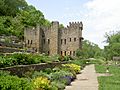
Château Laroche in Symmes Township lies in the Little Miami Valley.
-
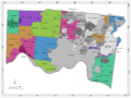
Map of Hamilton County, Ohio, with independent cities and villages in gray, and townships in colors
.jpg)

See also
 In Spanish: Condado de Hamilton (Ohio) para niños
