
Hana Highway facts for kids
Quick facts for kids
|
|||||||
|---|---|---|---|---|---|---|---|
| Hana Millennium Legacy Trail | |||||||
|
Hana Highway highlighted in red
|
|||||||
| Route information | |||||||
| Maintained by HDOT | |||||||
| Length | 64.40 mi (103.64 km) | ||||||
| Component highways |
|||||||
| Major junctions | |||||||
| West end | |||||||
| East end | |||||||
| Location | |||||||
| Counties: | Maui | ||||||
| Highway system | |||||||
Routes in Hawaii
|
|||||||
|
Hana Belt Road
|
|||||||

The Hana Highway Millennium Trail Monument and the Zero Mile Marker (under the Adopt-a-Highway sign) at the Junction of Route 36/360/365.
|
|||||||
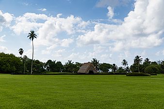
| Nearest city | Makawao, Hawaii | ||||||
| Area | 153 acres (62 ha) | ||||||
| Built | 1900 | ||||||
| Architectural style | Basalt arch, et al. | ||||||
| NRHP reference No. | 01000615 | ||||||
| Added to NRHP | June 15, 2001 | ||||||


The Hana Highway (colloquially referred to as The Road to Hana) is a 64.4-mile-long (103.6 km) stretch of Hawaii Routes 36 and 360 which connects Kahului to the town of Hana in east Maui. To the east of Kalepa Bridge, the highway continues to Kipahulu as Hawaii Route 31 (the Piilani Highway). Although Hana is only about 52 miles (84 km) from Kahului, an uninterrupted car-trip takes about 2.5 hours to drive, since the highway is very windy, narrow, and passes over 59 bridges, of which 46 are only one lane wide. There are approximately 620 curves along Route 360 from just east of Kahului to Hana, almost all of it through lush, tropical rainforest. Many of the concrete and steel bridges date back to 1910 and all but one are still in use. That one bridge, badly damaged by erosion, has been replaced by a portable steel ACROW bridge erected by the United States Army Corps of Engineers.
In August 2000, the highway was designated as the Hana Millennium Legacy Trail by President Bill Clinton, with the trail start designated in Pāʻia. The Hana Highway was listed on the National Register of Historic Places on June 15, 2001.
Contents
Tourism
The Hana Highway is a popular tourist attraction in Maui. Guidebooks often devote large sections to traveling the highway leading to the eastern side of Maui, documenting the many waterfalls and attractions that can be found along the way. Some of these attractions lie within or through private property and will often have "no trespassing" signs posted or even signs claiming that the attraction does not exist. All beaches in Hawaii are public. Some guidebooks document the "keep out" areas and ways past barbed wire fences and locked gates to reach attractions.
Beyond the town of Hana, the Hana Highway becomes Hawaii State Road 330 and leads to the ʻOheʻo Gulch where the Seven Sacred Pools are located within the Kipahulu Area of the Haleakala National Park.
Occasionally the dirt road past Route 31 is closed to traffic due to landslides. However, although it is somewhat rough in places, it is by no means a daunting or particularly dangerous road if taken slowly.
Scenic turnouts abound, including one for Wailua Falls near the Seven Sacred Pools in Oheʻo.
History
In the sixteenth century, Maui's King Pi'ilani conquered East Maui and drew Hana into his political sphere. Pi'ilani built the Alaloa, the "long road," from West Maui, a road on which travelers reportedly swung themselves over East Maui's rushing streams with ropes made of vines. Later, Piilani's son, Kihapiilani, extended the Alaloa into the Hana District. When completed, the road was 4 to 6 feet (1.2 to 1.8 m) wide, 138 miles (222 km), and paved with hand-fitted basalt (lava) rocks. Modern road construction to Hana began in the 1870s, with an unpaved road built to facilitate the construction of the Hämäkua Ditch. Part of The East Maui Irrigation System, the Hämäkua Ditch brought water from the rainforests of Haleakalā to semi-arid central Maui to support the sugarcane industry.
Road construction continued in the early 1900s and was extended piecemeal until the full road to Hana was officially opened on December 18, 1926. Construction of bridges continued through the 1930s and the road was not completely paved until the 1960s.
Major intersections
The entire route is in Maui County.
| Location | Mile | Roads intersected | Notes | |
|---|---|---|---|---|
| Kahului | 0.0 | 0.0 | Northern terminus of Route 36, western terminus of Hana Highway | |
| 0.2 | 0.32 | No southbound access, southern terminus of Route 32A | ||
| 0.6 | 0.97 | Western terminus of Route 36A | ||
| 0.9 | 1.4 | |||
| 2.9 | 4.7 | |||
| Paia | 6.7 | 10.8 | Baldwin Avenue – Makawao | |
| | 16.2 | 26.1 | Northern terminus of Route 365 Eastern terminus of Route 36, western terminus of Route 360 |
|
| Keanae | 32.8 | 52.8 | Keanae Road – Keanae | |
| Hana | 47.6 | 76.6 | ||
| 48.1 | 77.4 | Honokalani Road – Waianapanapa State Park | ||
| 49.9 | 80.3 | Uakea Road – Hana Bay | ||
| 50.6 | 81.4 | Keawa Place – Hana Bay | Former terminus of state maintenance | |
| Hamoa Beach | 52.4 | Haneoo Road – Hamoa Beach, Koki Beach | ||
| Haleakala National Park | 60.7 | Haleakala National Park – Kipahulu Area | Access to Oheʻo Gulch (Seven Sacred Pools) | |
| Kalepa Gulch | 64.4 | 103.6 | Kalepa Bridge | |
| Eastern terminus of Route 360 and the Hana Highway | ||||
| 1.000 mi = 1.609 km; 1.000 km = 0.621 mi | ||||
Gallery
-
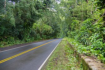
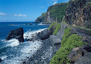
Section of highway between Nahiku and Waianapanapa State Park
-
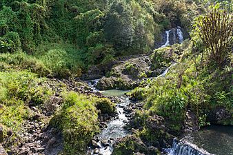
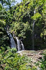
Waterfalls adjacent to Hana Highway
-
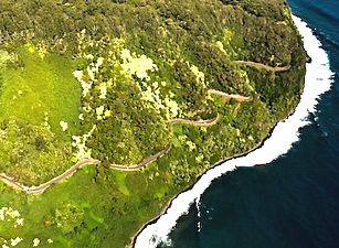
Aerial view of highway
-
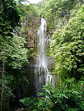
Wailua Falls
-
Upper Waikani Falls Maui Hawaii
-
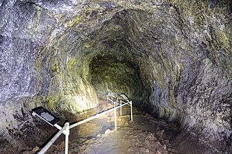
Hana Lava tube Maui, Hawaii
-
Highway between Haiku and Kaipahulu
-
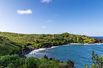
Waianapanapa black sand beach next to Hana
-
Kahanu garden old house Maui, Road to Hana
-
Finally Hana, Maui


.jpg)
.jpg)
.jpg)
.jpg)
.jpg)
.jpg)
| Browse numbered routes | ||||
|---|---|---|---|---|
| ← |
Route 36A |
|||
| ← |
Route 361 |
|||
