Hancock County, Iowa facts for kids
Quick facts for kids
Hancock County
|
|
|---|---|

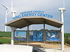
Visitor kiosk at the 148 wind turbine farm
|
|

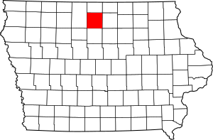
Location within the U.S. state of Iowa
|
|
 Iowa's location within the U.S. |
|
| Country | |
| State | |
| Founded | 1851 |
| Named for | John Hancock |
| Seat | Garner |
| Largest city | Garner |
| Area | |
| • Total | 573 sq mi (1,480 km2) |
| • Land | 571 sq mi (1,480 km2) |
| • Water | 2.0 sq mi (5 km2) 0.4% |
| Population
(2020)
|
|
| • Total | 10,795 |
| • Density | 18.839/sq mi (7.274/km2) |
| Time zone | UTC−6 (Central) |
| • Summer (DST) | UTC−5 (CDT) |
| Congressional district | 4th |
Hancock County is a county in the U.S. state of Iowa. As of the 2020 census, the population was 10,795. The county seat is Garner. The county was founded on January 15, 1851, and named in honor of John Hancock, a leader of the Continental Congress during the American Revolution.
Contents
Geography
According to the U.S. Census Bureau, the county has an area of 573 square miles (1,480 km2), of which 571 square miles (1,480 km2) is land and 2.0 square miles (5.2 km2) (0.4%) is water.
Major highways
 U.S. Highway 18
 U.S. Highway 69
 Iowa Highway 17
Adjacent counties
- Winnebago County (north)
- Cerro Gordo County (east)
- Wright County (south)
- Kossuth County (west)
Demographics
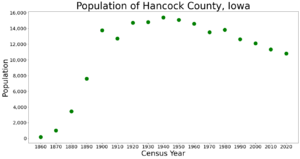
| Historical population | |||
|---|---|---|---|
| Census | Pop. | %± | |
| 1860 | 179 | — | |
| 1870 | 999 | 458.1% | |
| 1880 | 3,453 | 245.6% | |
| 1890 | 7,621 | 120.7% | |
| 1900 | 13,752 | 80.4% | |
| 1910 | 12,731 | −7.4% | |
| 1920 | 14,723 | 15.6% | |
| 1930 | 14,802 | 0.5% | |
| 1940 | 15,402 | 4.1% | |
| 1950 | 15,077 | −2.1% | |
| 1960 | 14,604 | −3.1% | |
| 1970 | 13,506 | −7.5% | |
| 1980 | 13,833 | 2.4% | |
| 1990 | 12,638 | −8.6% | |
| 2000 | 12,100 | −4.3% | |
| 2010 | 11,341 | −6.3% | |
| 2020 | 10,795 | −4.8% | |
| U.S. Decennial Census 1790-1960 1900-1990 1990-2000 2010-2018 |
|||
2020 census
The 2020 census recorded a population of 10,795 in the county, with a population density of 18.8912/sq mi (7.2939/km2). 95.32% of the population reported being of one race. 86.57% were non-Hispanic White, 0.70% were Black, 5.69% were Hispanic, 0.36% were Native American, 0.23% were Asian, 0.05% were Native Hawaiian or Pacific Islander and 6.40% were some other race or more than one race. There were 5,113 housing units, of which 4,585 were occupied.
2010 census
The 2010 census recorded a population of 11,341 in the county, with a population density of 19.8578/sq mi (7.6671/km2). There were 5,330 housing units, of which 4,741 were occupied.
Communities
Cities
Census-designated places
Other unincorporated community
Townships
Hancock County is divided into sixteen townships:
- Amsterdam
- Avery
- Bingham
- Boone
- Britt
- Concord
- Crystal
- Ell
- Ellington
- Erin
- Garfield
- Liberty
- Madison
- Magor
- Orthel
- Twin Lake
Population ranking
The population ranking of the following table is based on the 2010 census of Hancock County.
† county seat
| Rank | City/Town/etc. | Municipal type | Population (2010 Census) |
|---|---|---|---|
| 1 | Forest City (partially in Winnebago County) | City | 4,151 |
| 2 | † Garner | City | 3,129 |
| 3 | Britt | City | 2,069 |
| 4 | Kanawha | City | 652 |
| 5 | Klemme | City | 507 |
| 6 | Corwith | City | 309 |
| 7 | Crystal Lake | City | 250 |
| 8 | Woden | City | 229 |
| 9 | Goodell | City | 139 |
| 10 | Duncan | CDP | 131 |
| 11 | Miller | CDP | 60 |
| 12 | Hayfield | CDP | 43 |
| 13 | Hutchins | CDP | 28 |
Economy
As of December 2008, the unemployment rate in Hancock County was 9.1%, a sharp rise from 4.0% in December 2007. In 2016 the unemployment rate dropped back to 2.2%.
See also
 In Spanish: Condado de Hancock (Iowa) para niños


