
Hancock County, Tennessee facts for kids
Quick facts for kids
Hancock County
|
|
|---|---|
| County of Hancock | |

Hancock County Courthouse in Sneedville
|
|

Location within the U.S. state of Tennessee
|
|
 Tennessee's location within the U.S. |
|
| Country | |
| State | |
| Founded | 1844 |
| Named for | John Hancock |
| Seat | Sneedville |
| Largest town | Sneedville |
| Area | |
| • Total | 223 sq mi (580 km2) |
| • Land | 222 sq mi (570 km2) |
| • Water | 1.2 sq mi (3 km2) 0.5%% |
| Population
(2020)
|
|
| • Total | 6,662 |
| • Density | 31/sq mi (12/km2) |
| Time zone | UTC−5 (Eastern) |
| • Summer (DST) | UTC−4 (EDT) |
| Congressional district | 1st |
Hancock County is a county located in the northeastern part of the U.S. state of Tennessee. As of the 2020 census, the population was 6,662, making it the fourth-least populous county in Tennessee. Its county seat is Sneedville.
Contents
History
Hancock County was created from parts of Hawkins and Claiborne counties. The act establishing the county was passed by the state legislature in 1844, but several Hawkins residents sued to block its creation. In 1848, the Tennessee Supreme Court ruled in favor of the new county. The county seat, Sneedville, was named in honor of attorney William H. Sneed, who represented the county in the court case. The county was named for Revolutionary War patriot John Hancock.
Geography
According to the U.S. Census Bureau, the county has a total area of 223 square miles (580 km2), of which 222 square miles (570 km2) is land and 1.2 square miles (3.1 km2) (0.5%) is water.
Adjacent counties
- Lee County, Virginia (north)
- Scott County, Virginia (northeast)
- Hawkins County (east)
- Grainger County (southwest)
- Claiborne County (west)
State protected areas
- Kyles Ford Wildlife Management Area (part)
Demographics
| Historical population | |||
|---|---|---|---|
| Census | Pop. | %± | |
| 1850 | 5,660 | — | |
| 1860 | 7,020 | 24.0% | |
| 1870 | 7,148 | 1.8% | |
| 1880 | 9,098 | 27.3% | |
| 1890 | 10,342 | 13.7% | |
| 1900 | 11,147 | 7.8% | |
| 1910 | 10,778 | −3.3% | |
| 1920 | 10,454 | −3.0% | |
| 1930 | 9,673 | −7.5% | |
| 1940 | 11,231 | 16.1% | |
| 1950 | 9,116 | −18.8% | |
| 1960 | 7,757 | −14.9% | |
| 1970 | 6,719 | −13.4% | |
| 1980 | 6,887 | 2.5% | |
| 1990 | 6,739 | −2.1% | |
| 2000 | 6,786 | 0.7% | |
| 2010 | 6,819 | 0.5% | |
| 2020 | 6,662 | −2.3% | |
| U.S. Decennial Census 1790-1960 1900-1990 1990-2000 2010-2020 2020 |
|||

2020 census
| Race | Number | Percentage |
|---|---|---|
| White (non-Hispanic) | 6,391 | 95.93% |
| Black or African American (non-Hispanic) | 33 | 0.5% |
| Native American | 25 | 0.38% |
| Asian | 1 | 0.02% |
| Other/Mixed | 172 | 2.58% |
| Hispanic or Latino | 40 | 0.6% |
As of the 2020 United States census, there were 6,662 people, 2,742 households, and 1,729 families residing in the county.
2010 census
At the 2010 United States Census, there were 6,819 people living in the county. 98.0% were White, 0.4% Black or African American, 0.3% Native American, 0.1% Asian, 0.1% of some other race and 1.1% of two or more races. 0.2% were Hispanic or Latino (of any race).
Culture
Hancock County is known particularly for its population of people of Melungeon ancestry, who are believed to be of mixed European, African, and Native American heritage. The Vardy Community School, which provided state-mandated education for Melungeon children in the early 20th century, is now a historic site located in the Newman's Ridge area.
Communities
Town
- Sneedville (county seat)
Unincorporated communities
- Alanthus Hill
- Kyles Ford
- Mulberry Gap
- Treadway
- Xenophon
Images for kids
-
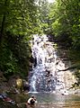
Elrod Falls in Hancock County

See also
 In Spanish: Condado de Hancock (Tennessee) para niños
