Hardin, Montana facts for kids
Quick facts for kids
Hardin
He'konemâhoeve'ho'eno
|
|
|---|---|

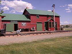
Former train depot, originally from Lodge Grass, now featured among other buildings at the Big Horn County Historical Museum in Hardin.
|
|
| Motto(s):
A city with a reason. . .
|
|

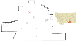
Location of Hardin, Montana
|
|
| Country | United States |
| State | Montana |
| County | Big Horn |
| Area | |
| • Total | 2.97 sq mi (7.70 km2) |
| • Land | 2.97 sq mi (7.70 km2) |
| • Water | 0.00 sq mi (0.00 km2) |
| Elevation | 2,907 ft (886 m) |
| Population
(2020)
|
|
| • Total | 3,818 |
| • Density | 1,285.52/sq mi (495.84/km2) |
| Time zone | UTC-7 (Mountain (MST)) |
| • Summer (DST) | UTC-6 (MDT) |
| ZIP code |
59034
|
| Area code(s) | 406 Exchange: 665 |
| FIPS code | 30-34225 |
| GNIS feature ID | 0772140 |
| Website | www.hardinmt.com |
Hardin is a city in and the county seat of Big Horn County, Montana, United States. The population was 3,818 at the 2020 census.
It is located just north of the Crow Indian Reservation.
Contents
History
The city was named for Samuel Hardin, a friend of developer Charles Henry Morrill.
Geography
Hardin is located at 45°43′55″N 107°36′45″W / 45.73194°N 107.61250°W (45.731824, -107.612542).
According to the United States Census Bureau, the city has a total area of 2.57 square miles (6.66 km2), all of it land.
Demographics
| Historical population | |||
|---|---|---|---|
| Census | Pop. | %± | |
| 1920 | 1,312 | — | |
| 1930 | 1,169 | −10.9% | |
| 1940 | 1,886 | 61.3% | |
| 1950 | 2,306 | 22.3% | |
| 1960 | 2,789 | 20.9% | |
| 1970 | 2,733 | −2.0% | |
| 1980 | 3,300 | 20.7% | |
| 1990 | 2,940 | −10.9% | |
| 2000 | 3,384 | 15.1% | |
| 2010 | 3,505 | 3.6% | |
| 2020 | 3,818 | 8.9% | |
| U.S. Decennial Census | |||
2010 census
As of the census of 2010, there were 3,505 people, 1,301 households, and 850 families living in the city. The population density was 1,363.8 inhabitants per square mile (526.6/km2). There were 1,401 housing units at an average density of 545.1 per square mile (210.5/km2). The racial makeup of the city was 49.8% White, 0.7% African American, 40.8% Native American, 1.2% Asian, 0.1% Pacific Islander, 2.2% from other races, and 5.1% from two or more races. Hispanic or Latino of any race were 7.1% of the population.
There were 1,301 households, of which 37.2% had children under the age of 18 living with them, 43.4% were married couples living together, 15.4% had a female householder with no husband present, 6.5% had a male householder with no wife present, and 34.7% were non-families. 30.7% of all households were made up of individuals, and 14.4% had someone living alone who was 65 years of age or older. The average household size was 2.64 and the average family size was 3.29.
The median age in the city was 33.2 years. 29.7% of residents were under the age of 18; 10.1% were between the ages of 18 and 24; 22.1% were from 25 to 44; 24.7% were from 45 to 64; and 13.3% were 65 years of age or older. The gender makeup of the city was 48.7% male and 51.3% female.
Events
The Hardin Area Chamber of Commerce and Agriculture conducts the annual Little Big Horn Days festival in the 3rd weekend in June, to include the Custer's Last Stand Reenactment.
Climate
Hardin experiences a semi-arid climate (Köppen BSk) with cold, dry winters and hot, wetter summers.
| Climate data for Hardin, Montana | |||||||||||||
|---|---|---|---|---|---|---|---|---|---|---|---|---|---|
| Month | Jan | Feb | Mar | Apr | May | Jun | Jul | Aug | Sep | Oct | Nov | Dec | Year |
| Record high °F (°C) | 70 (21) |
74 (23) |
84 (29) |
96 (36) |
97 (36) |
106 (41) |
112 (44) |
109 (43) |
104 (40) |
94 (34) |
81 (27) |
69 (21) |
112 (44) |
| Average high °F (°C) | 35.4 (1.9) |
42.7 (5.9) |
52.2 (11.2) |
63.0 (17.2) |
73.0 (22.8) |
82.5 (28.1) |
90.7 (32.6) |
90.2 (32.3) |
78.6 (25.9) |
65.3 (18.5) |
47.2 (8.4) |
37.2 (2.9) |
63.2 (17.3) |
| Daily mean °F (°C) | 23.2 (−4.9) |
29.3 (−1.5) |
38.2 (3.4) |
48.2 (9.0) |
57.8 (14.3) |
66.4 (19.1) |
73.1 (22.8) |
72.2 (22.3) |
61.2 (16.2) |
49.5 (9.7) |
34.7 (1.5) |
25.2 (−3.8) |
48.3 (9.0) |
| Average low °F (°C) | 10.9 (−11.7) |
15.9 (−8.9) |
24.2 (−4.3) |
33.3 (0.7) |
42.5 (5.8) |
50.3 (10.2) |
55.4 (13.0) |
54.1 (12.3) |
43.7 (6.5) |
33.6 (0.9) |
22.1 (−5.5) |
13.2 (−10.4) |
33.3 (0.7) |
| Record low °F (°C) | −42 (−41) |
−38 (−39) |
−29 (−34) |
1 (−17) |
15 (−9) |
30 (−1) |
34 (1) |
32 (0) |
15 (−9) |
−13 (−25) |
−31 (−35) |
−47 (−44) |
−47 (−44) |
| Average precipitation inches (mm) | 0.61 (15) |
0.35 (8.9) |
0.67 (17) |
1.37 (35) |
1.98 (50) |
1.66 (42) |
1.14 (29) |
0.65 (17) |
1.28 (33) |
1.29 (33) |
0.60 (15) |
0.47 (12) |
12.07 (306.9) |
| Source 1: NOAA (normals, 1971–2000) | |||||||||||||
| Source 2: The Weather Channel (Records) | |||||||||||||
Economy
Hardin hosts a bitcoin mining facility by Marathon Patent Group, according to a press release by the company.
Education
Hardin Public Schools serves students from kindergarten to 12th grade. Hardin High School's team name is the Bulldogs.
The Big Horn County Library operates in Hardin.
Infrastructure
Big Horn County Airport is a public use airport located 3 miles west of town.
Notable people
- Kroy Biermann - NFL defensive end
- Kendall Cross - Olympic Gold Medalist in Freestyle Wrestling
- Tim Fox - Attorney General of Montana
See also
 In Spanish: Hardin (Montana) para niños

