Harris County, Georgia facts for kids
Quick facts for kids
Harris County
|
|
|---|---|

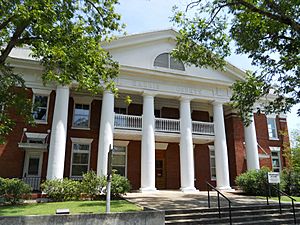
County courthouse in Hamilton
|
|

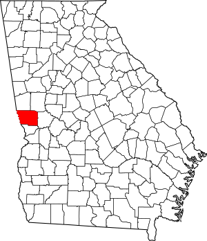
Location within the U.S. state of Georgia
|
|
 Georgia's location within the U.S. |
|
| Country | |
| State | |
| Founded | December 14, 1827 |
| Named for | Charles Harris |
| Seat | Hamilton |
| Largest city | Pine Mountain |
| Area | |
| • Total | 473 sq mi (1,230 km2) |
| • Land | 464 sq mi (1,200 km2) |
| • Water | 9.1 sq mi (24 km2) 1.9%% |
| Population | |
| • Estimate
(2020)
|
36,080 |
| • Density | 73/sq mi (28/km2) |
| Time zone | UTC−5 (Eastern) |
| • Summer (DST) | UTC−4 (EDT) |
| Congressional district | 3rd |
Harris County is a county located in the west-central portion of the U.S. state of Georgia; its western border with the state of Alabama is formed by the Chattahoochee River. As of the 2010 census, the population was 32,024. The county seat is Hamilton. The largest city in the county is Pine Mountain, a resort town that is home to the world-famous Callaway Gardens Resort and Franklin D. Roosevelt State Park (the largest state park in Georgia). Harris County was created on December 14, 1827, and named for Charles Harris, a Georgia judge and attorney.
Harris County is part of the Columbus, GA-AL metropolitan area and has become a popular suburban and exurban destination of residence for families relocating from Columbus. Because of this, Harris has become the sixth-wealthiest county in Georgia in terms of per capita income and the wealthiest in the state outside of Metro Atlanta.
Contents
History
The county was settled by European Americans largely after the federal government had forcibly removed the indigenous Creek people (Muscogee), who were relocated to Indian Territory west of the Mississippi River. In the antebellum era, parts of the county were developed for cotton plantations, the premier commodity crop. Planters imported numerous slaves from the Upper South through the domestic slave trade as workers.
The County courthouse was designed by Edward Columbus Hosford of Georgia and completed in 1906.
By the late 19th century, there had been numerous interracial relationships between whites and blacks both before and after the war; many residents were of mixed race, typically with European ancestry through the paternal line. There were 200 years of families with many inter-connections among them; justice was nearly always meted out to kin. Periodically some of the whites would try to reduce the relations of white men with mixed-race and black women, a movement that started in the late 19th century. The mountain areas of the county had moonshiners in the late 19th and early 20th centuries; both whites and blacks took part in this.
The county is now part of the Columbus, Georgia metropolitan area, which has become industrialized and developed a more varied economy. By per capita income, the county is the sixth-wealthiest in the state of Georgia, and the wealthiest county in the state outside of Metro Atlanta.
Geography
According to the U.S. Census Bureau, the county has a total area of 473 square miles (1,230 km2), of which 464 square miles (1,200 km2) is land and 9.1 square miles (24 km2) (1.9%) is water.
The majority of Harris County is located in the Middle Chattahoochee River-Lake Harding sub-basin of the ACF River Basin (Apalachicola-Chattahoochee-Flint River Basin), with the exception of the county's southeastern border area, south of Ellerslie, which is located in the Middle Chattahoochee River-Walter F. George Lake sub-basin of the same ACF River Basin.
Major highways
 Interstate 85
 Interstate 185
 U.S. Route 27
 U.S. Route 27 Alternate
 State Route 1
 State Route 18
 State Route 36
 State Route 85
 State Route 85 Alternate
 State Route 103
 State Route 116
 State Route 190
 State Route 208
 State Route 219
 State Route 315
 State Route 354
 State Route 403 (unsigned designation for I-85)
 State Route 411 (unsigned designation for I-185)
Adjacent counties
- Troup County (north)
- Meriwether County (northeast)
- Talbot County (east)
- Muscogee County (south)
- Lee County, Alabama (southwest/CST Border)
- Chambers County, Alabama (northwest/CST Border except Lanett and Valley as the cities are jointed by the Columbus Metropolitan Area)
Demographics
| Historical population | |||
|---|---|---|---|
| Census | Pop. | %± | |
| 1830 | 5,105 | — | |
| 1840 | 13,933 | 172.9% | |
| 1850 | 14,721 | 5.7% | |
| 1860 | 13,736 | −6.7% | |
| 1870 | 13,284 | −3.3% | |
| 1880 | 15,758 | 18.6% | |
| 1890 | 16,797 | 6.6% | |
| 1900 | 18,009 | 7.2% | |
| 1910 | 17,886 | −0.7% | |
| 1920 | 15,775 | −11.8% | |
| 1930 | 11,140 | −29.4% | |
| 1940 | 11,428 | 2.6% | |
| 1950 | 11,265 | −1.4% | |
| 1960 | 11,167 | −0.9% | |
| 1970 | 11,520 | 3.2% | |
| 1980 | 15,464 | 34.2% | |
| 1990 | 17,788 | 15.0% | |
| 2000 | 23,695 | 33.2% | |
| 2010 | 32,024 | 35.2% | |
| 2020 (est.) | 36,080 | 12.7% | |
| U.S. Decennial Census 1790-1960 1900-1990 1990-2000 2010-2013 2017 |
|||
2020 census
| Race | Num. | Perc. |
|---|---|---|
| White (non-Hispanic) | 25,925 | 74.78% |
| Black or African American (non-Hispanic) | 5,170 | 14.91% |
| Native American | 101 | 0.29% |
| Asian | 388 | 1.12% |
| Pacific Islander | 21 | 0.06% |
| Other/Mixed | 1,646 | 4.75% |
| Hispanic or Latino | 1.417 | 4.09% |
As of the 2020 United States census, there were 34,668 people, 12,156 households, and 9,581 families residing in the county.
2010 census
As of the 2010 United States Census, there were 32,024 people, 11,823 households, and 9,268 families residing in the county. The population density was 69.0 inhabitants per square mile (26.6/km2). There were 13,397 housing units at an average density of 28.9 per square mile (11.2/km2). The racial makeup of the county was 79.3% white, 17.2% black or African American, 0.9% Asian, 0.3% American Indian, 0.1% Pacific islander, 0.7% from other races, and 1.5% from two or more races. Those of Hispanic or Latino origin made up 2.7% of the population. In terms of ancestry, 17.2% identified as having African ancestry; 13.5% were German, 13.4% were Irish, 11.5% were English, and 10.5% identified as having American ancestry.
Of the 11,823 households, 35.8% had children under the age of 18 living with them, 64.0% were married couples living together, 10.3% had a female householder with no husband present, 21.6% were non-families, and 18.5% of all households were made up of individuals. The average household size was 2.67 and the average family size was 3.04. The median age was 42.0 years.
The median income for a household in the county was $67,018 and the median income for a family was $74,457. Males had a median income of $49,844 versus $37,103 for females. The per capita income for the county was $31,073. About 6.0% of families and 9.0% of the population were below the poverty line, including 9.3% of those under age 18 and 10.5% of those age 65 or over.
Communities
Cities
- Hamilton - county seat
- Shiloh
- West Point
Towns
Unincorporated communities
- Cataula
- Ellerslie
- Fortson
- Midland
- Mountain Hill
- Pine Mountain Valley
- Piney Grove
- Rehobeth
- Ridgeway
- Whitesville
Education
The Harris County School District holds preschool to grade 12 and consists of four elementary schools, an intermediate school, a middle school, and a high school. The district headquarters is located in Hamilton, and has 274 full-time teachers and over 4,411 students spread out over seven schools.
- Mulberry Creek Elementary School (Cataula)
- New Mountain Hill Elementary School (Fortson)
- Park Elementary School (Hamilton)
- Pine Ridge Elementary School (Ellerslie)
- Creekside Intermediate School (grades 5–6) (Cataula)
- Harris County Carver Middle School (Hamilton)
- Harris County High School (Hamilton)
Notable people
- Georgia Militia Colonel Reuben J. Crews, father of C.C. Crews
- Benjamin Franklin White, clerk of the Inferior Court of Harris County, and mayor of Whitesville, compiler of the shape note songbook known as The Sacred Harp
See also
 In Spanish: Condado de Harris (Georgia) para niños


